
‘Sahel’ region of Sahara desert is associated with
- (a)core area of Sahara desert
- (b)southern moving edge of Sahara desert
- (c)northern fringe of Sahara desert bordering Mediterranean sea
- (d)another name of Sahara desert
Answer
Why
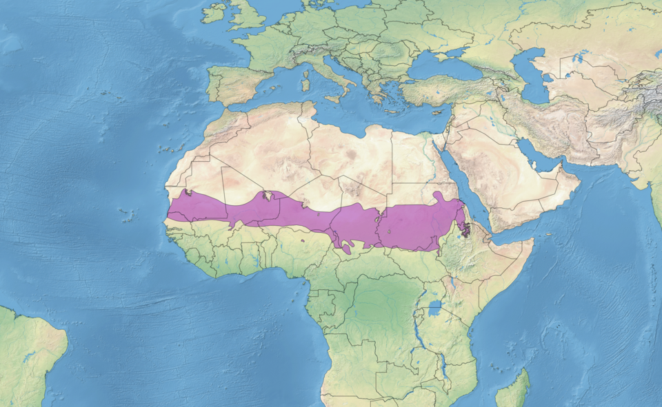
Correct: B, the southern moving edge of the Sahara desert. The name gives the answer away to anyone who knows it: Sahel comes from the Arabic word for shore or coast, and the belt is pictured as the shoreline of the desert imagined as a sea. It is the semi-arid transition zone that runs along the whole southern margin of the Sahara, from the Atlantic coast of Senegal and Mauritania eastwards through Mali, Burkina Faso, Niger, northern Nigeria and Chad to Sudan and the Red Sea. Rainfall there is roughly 100 to 600 mm a year, delivered in one short summer wet season, so the vegetation grades from thorn scrub in the north to open savanna in the south. The word 'moving' in the option matters too: this margin shifts with the rains, and the long droughts of 1968 to 1974 and again in the 1980s pushed desert conditions south across it, which is why the Sahel is the textbook case of desertification.
Why the others are wrong
- (a)core area of Sahara desert: The Sahara's core is hyper-arid, with some stations recording no measurable rain for years at a time. The Sahel is by definition a margin, not a centre, and it carries enough grass and thorn scrub to support herding.
- (c)northern fringe of Sahara desert bordering Mediterranean sea: That northern strip is the Maghreb (the coastlands of Morocco, Algeria, Tunisia and Libya) and it has a Mediterranean climate with winter rain. It is the mirror image of the Sahel, on the wrong side of the desert.
- (d)another name of Sahara desert: The two words are not synonyms. Sahara comes from the Arabic for desert, while Sahel means the shore of that desert, so the names themselves mark the difference between the body and its edge.
Concept
The Sahel is the semi-arid belt separating the Sahara from the wetter Sudanian savanna to its south, a band running the full width of Africa. Its rainfall is low, concentrated into a brief summer season and highly variable from year to year, so its boundaries are not fixed lines but zones that migrate with the rains. Pastoral herding and rain-fed millet and sorghum are the traditional livelihoods, and both are acutely exposed to a failed wet season.
This is a vocabulary-and-place item, and the reliable way in is the meaning of the name. Once 'shore of the desert' is fixed, options (a) and (d) fall away at once, and the only remaining decision is which shore. The southern one is right, because the Sahara's northern edge meets the Mediterranean coastlands, a region with an entirely different climate and its own name. As of the September 2016 exam the Sahel was best known for drought and desertification, and the African Union's Great Green Wall initiative of 2007 was the headline response. Since then the belt has become far better known for insecurity (military takeovers in Mali, Burkina Faso and Niger, and armed conflict across the region) and UPSC set a question on exactly that in 2024.
Key facts
- Sahel is Arabic for shore or coast; the belt is imagined as the shoreline of the desert.
- It stretches from the Atlantic coast to the Red Sea, crossing Senegal, Mauritania, Mali, Burkina Faso, Niger, northern Nigeria, Chad and Sudan.
- Annual rainfall is roughly 100 to 600 mm, falling in a single short summer wet season.
- Severe droughts in 1968 to 1974 and again in the 1980s made the Sahel the standard example of desertification.
- The African Union launched the Great Green Wall initiative in 2007 to restore degraded land along the belt.
Study next
Common traps
- Assuming Sahel and Sahara are two names for the same thing because they sound alike.
- Placing the Sahel on the Mediterranean side, which is the Maghreb.
World regional geography in NDA GAT is usually one-line placement (name a region, a desert or a river and ask where it is) so build the habit of attaching each name to a continent, a latitude band and a neighbour.
Related PYQs
Consider the following statements : Statement-I : There is instability and worsening security situation in the Sahel region. Statement-II : There have been military takeovers/coups d’état in several countries of the Sahel region in the recent past. Which one of the following is correct in respect of the above statements ?
- (a) Both Statement-I and Statement-II are correct and Statement-II explains Statement-I
- (b) Both Statement-I and Statement-II are correct, but Statement-II does not explain Statement-I
- (c) Statement-I is correct, but Statement-II is incorrect
- (d) Statement-I is incorrect, but Statement-II is correct
Answer(a) Both Statement-I and Statement-II are correct and Statement-II explains Statement-I
The same region eight years later, and in the same statement-pair format used by the block this question belongs to: it shows how the Sahel moved from a physical-geography topic to a current-affairs one.
Taklamakan Desert is situated in
- (a) Western Asia
- (b) Southern fringe of Sahara in Africa
- (c) South America
- (d) Central Asia
Answer(d) Central Asia
A world-desert placement item that offers 'southern fringe of Sahara' as a distractor: the very belt this question calls the Sahel.
Practice
- practice, not a real PYQ
The Sahel belt of Africa lies between the Sahara and
- (a)the Mediterranean coastlands
- (b)the Sudanian savanna
- (c)the Congo rainforest
- (d)the Kalahari desert
Answer(b) the Sudanian savanna: the Sahel is the dry transition from the desert to the wetter savanna south of it. - practice, not a real PYQ
The Great Green Wall initiative, launched by the African Union in 2007, is intended chiefly to
- (a)generate wind power across North Africa
- (b)check desertification along the southern edge of the Sahara
- (c)build a continental railway network
- (d)protect the Congo basin rainforest
Answer(b) check desertification along the southern edge of the Sahara: a belt of restored land across the Sahel.