
Karmanasa river originates in -
- (a)Kaimur District
- (b)Vaishali District
- (c)Patna District
- (d)Bikram District
Answer
Why
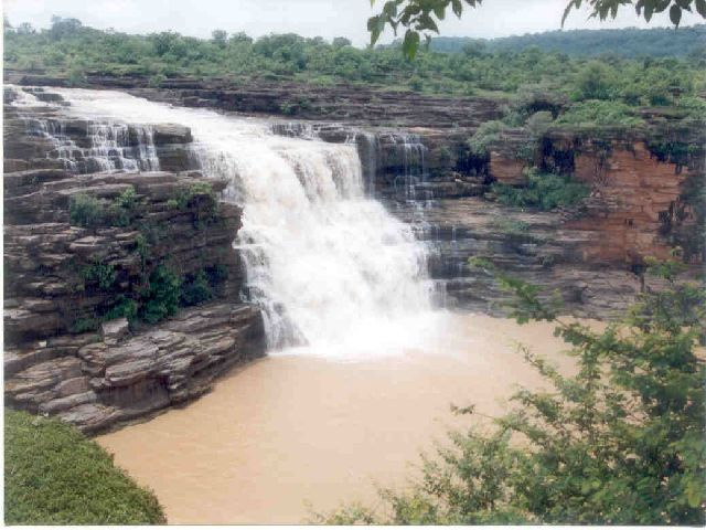
Correct — A, Kaimur District. The Karmanasa (Karamnasa) rises at about 350 metres on the northern face of the Kaimur Range, near Sarodag in Kaimur district of Bihar. The Commission put the reasoning in a single line when it rejected objections to this item: 'River Karmanasa originates in Kaimur Hills and not in the plains.' That is the whole physics of the question — a river needs relief to be born, and of the four districts offered only Kaimur sits on upland. From Sarodag the river descends the Kaimur escarpment by a succession of leaps, including the Karkatgarh, Devdari and Chhanpathar falls, then turns north-west across the plains south of Mirzapur, becomes the boundary between Uttar Pradesh and Bihar, and finally joins the Ganga near Chausa in Buxar district, opposite Bara village in Ghazipur district of Uttar Pradesh. Its total length is 192 km, of which 116 km lie inside Uttar Pradesh and the remaining 76 km form the interstate boundary; with its tributaries — the Durgavati, Chandraprabha, Karunuti, Nadi, Goriya and Khajuri — it drains 11,709 sq km. Along that boundary stretch it has Sonbhadra, Chandauli, Varanasi and Ghazipur on its left bank and Kaimur and Buxar on its right. The name means 'destroyer of religious merit', which is why tradition treats crossing it as inauspicious; the legend traces the stream to the saliva of King Trishanku, left hanging head-down in mid-air after Vishvamitra's rival creation was stopped by Indra.
Why the others are wrong
- (b)Vaishali District — Vaishali lies north of the Ganga in the Tirhut division, with its headquarters at Hajipur, on flat alluvium built by the Gandak and its distributaries. Nothing rises there. The Karmanasa is a south-bank stream in the extreme south-west corner of Bihar, on the other side of the Ganga and roughly 200 km away. Vaishali is examined for the Licchavi republic and for Mahavira, not for river sources.
- (c)Patna District — Patna is the obvious guess for anyone matching a Bihar question to the only Bihar district they can place on a map. But Patna district is pure Gangetic alluvium with no relief to speak of. Rivers converge on Patna — the Ganga, the Son at Maner, the Punpun, the Gandak opposite at Sonepur — they do not begin there. A flat floodplain district can be a confluence, never a source.
- (d)Bikram District — The give-away, once you notice it: Bihar has 38 districts and Bikram is not among them. Bikram is a town and community development block inside Patna district, on the road towards Arrah. An option that names a unit which does not exist can never be the answer, so this one can be struck out before any geography is recalled — a useful habit in a paper that carries a one-third negative mark.
Concept
Bihar's drainage is split in two by the Ganga, and the split is the key to almost every river question the state sets. The north-bank tributaries — Ghaghara, Gandak, Burhi Gandak, Bagmati, Kamla Balan, Kosi and Mahananda — rise in Nepal and the Himalaya, carry snowmelt as well as monsoon rain, run in shifting braided channels over deep alluvium and give north Bihar its flood problem. The south-bank tributaries — Karmanasa, Son, Punpun, Phalgu, Sakri, Kiul and Chandan — rise on the Vindhyan and Chota Nagpur uplands, are wholly rain-fed and seasonal, and cut entrenched beds in rock before spilling on to the plain. The Karmanasa is the westernmost of that southern set inside Bihar. Its source range, the Kaimur, is the eastern portion of the Vindhya Range: roughly 483 km long, running from around Katangi in Jabalpur district of Madhya Pradesh to around Sasaram in Rohtas district of Bihar, never more than a few hundred metres above the surrounding plains and up to about 80 km wide. Along it runs a descending staircase of plateaus — Panna, then Bhander, then Rewa, ending in the Rohtas Plateau of Bihar — with a well-marked fall line where every north-flowing stream drops off the scarp. That fall line is why the Kaimur country is full of waterfalls between 15 m and 180 m high, the Devdari fall, about 58 m, being placed on the Karmanasa by some accounts and on the Chandraprabha by the Chandauli district administration; the Chhanpathar fall is about 30 m. A river treated as polluting is also a river people do not settle across, and the Karmanasa duly served as a political frontier: it marked the western boundary of the Sena dynasty of Bengal, and the Grand Trunk Road still crosses it at the state border. Two small dams, the Latif Shah bund and the Nuagarh dam, hold it today, and its valley carries one of India's important early-iron sites, Raja Nal Ka Tila in northern Sonbhadra, where excavation yielded iron artefacts dated to roughly 1200–1300 BCE.
Work this question physically rather than by memory and it takes ten seconds. Step one: a river originates where there is relief, so ask which of the four districts has any. Vaishali and Patna are middle-Ganga plain districts on alluvium; only Kaimur sits on the Vindhyan upland, its southern half occupied by the Kaimur plateau and the Kaimur Wildlife Sanctuary. Step two: eliminate the impossible option — there is no Bikram district in Bihar at all, so option (d) is dead on arrival. Step three: check the position on the map. The Karmanasa runs along the Uttar Pradesh–Bihar boundary in the extreme south-west; Vaishali is north of the Ganga and well to the east, and Patna is the state capital in the middle of the plain. The single discriminating fact is the source itself: 350 metres, on the northern face of the Kaimur Range near Sarodag. One further trap deserves naming. Because 116 of the river's 192 km lie inside Uttar Pradesh and it is best known from the Grand Trunk Road bridge on the state border, many candidates file the Karmanasa as 'a UP river' and then hunt for a plausible Bihar district instead of recalling that it is born in Bihar and dies in Bihar, at Chausa.
Key facts
- The Karmanasa rises at about 350 m on the northern face of the Kaimur Range near Sarodag in Kaimur district, Bihar; BPSC's own remark on this question states that it 'originates in Kaimur Hills and not in the plains'.
- Length 192 km: 116 km inside Uttar Pradesh and 76 km forming the UP–Bihar boundary; catchment 11,709 sq km with the Durgavati, Chandraprabha, Karunuti, Nadi, Goriya and Khajuri as tributaries; it meets the Ganga at Chausa in Buxar district, opposite Bara in Ghazipur district.
- The Kaimur Range is the eastern portion of the Vindhya Range — about 483 km from Katangi in Jabalpur district (Madhya Pradesh) to Sasaram in Rohtas district (Bihar), up to 80 km wide, ending in the Rohtas Plateau.
- Kaimur is one of Bihar's 38 districts, headquartered at Bhabua and carved out of Rohtas district in 1991; area 3,362 sq km, population 1,626,384 in the 2011 Census, and it holds the Kaimur Wildlife Sanctuary, the Mundeshwari temple and the Karkat and Telhar waterfalls.
- The Battle of Chausa was fought on 26 June 1539 on the banks of the Karmanasa where it meets the Ganga: Sher Khan defeated the Mughal emperor Humayun there and assumed the title Sher Shah — the same river name links Bihar's physical geography to its medieval history.
Study next
Common traps
- Choosing Patna because it is the only Bihar district a candidate can place with confidence — a flat alluvial district can host a confluence but cannot be a river source
- Treating the Karmanasa as a river of Uttar Pradesh because most of its course lies there; it rises in Bihar and joins the Ganga in Bihar, at Chausa in Buxar district
- Failing to notice that one option, 'Bikram District', does not exist — Bikram is a block of Patna district, and spotting non-existent units is worth a mark in negatively marked papers
BPSC asks Bihar river questions at district resolution — name the district of the source, the district of the confluence, the district a project irrigates — and it freely plants a block or a town among the districts to punish anyone who has not seen Bihar's administrative map. UPSC almost never goes below state level: it asks for the west-to-east order in which tributaries join the Ganga, for river–confluence or river–national-park pairings, or for the structural reason a river behaves as it does. Learn Bihar's rivers by district for BPSC and by system for UPSC.
Related PYQs
Which one of the following statements is not correct?
- (a) Mahanadi River rises in Chhattisgarh
- (b) Godavari River rises in Maharashtra
- (c) Cauvery River rises in Andhra Pradesh
- (d) Tapti River rises in Madhya Pradesh
Answer(c) Cauvery River rises in Andhra Pradesh
The same test in UPSC's idiom — match each river to the upland where it is born. The Cauvery statement fails because the river rises at Talakaveri in the Brahmagiri hills of Karnataka, exactly as 'Patna' or 'Vaishali' fails here: a river source has to be located in relief, and the answer turns on placing that relief correctly.
At which one of the following places do two important rivers of India originate; while one of them flows towards north and merges with another important river flowing towards Bay of Bengal, the other one flows towards Arabian Sea ?
- (a) Amarkantak
- (b) Badrinath
- (c) Mahabaleshwar
- (d) Nasik
Answer(a) Amarkantak
Amarkantak is the source of the Son, the Karmanasa's big neighbour among the Ganga's south-bank tributaries in Bihar, and of the westward Narmada. Both questions rest on the same idea: the Vindhyan uplands are the watershed from which the Ganga's right-bank rivers descend northwards to the plain.
Practice
- practice — not a real PYQ
The Karmanasa river joins the Ganga near which of the following places?
- (a)Chausa (Buxar)
- (b)Maner (Patna)
- (c)Sonepur (Saran)
- (d)Kursela (Katihar)
Answer(a) Chausa (Buxar) — the Karmanasa meets the Ganga at Chausa, opposite Bara village in Ghazipur district of Uttar Pradesh. Maner is where the Son joins the Ganga, Sonepur is the Gandak confluence and Kursela the Kosi confluence. - practice — not a real PYQ
The Kaimur Range, on which the Karmanasa river rises, is the eastern portion of which of the following ranges?
- (a)Satpura Range
- (b)Vindhya Range
- (c)Aravalli Range
- (d)Maikal Range
Answer(b) Vindhya Range — the Kaimur is the eastern part of the Vindhyas, running roughly 483 km from Katangi in Madhya Pradesh to Sasaram in Bihar. The Satpura lies south of the Narmada, the Maikal is a spur of the Satpura around Amarkantak, and the Aravalli is in Rajasthan.