
Strait of Hormuz connects -
- (a)The Persian Gulf to Gulf of Oman
- (b)Red sea to Gulf of Aden
- (c)Red sea to Indian Ocean
- (d)Mediterranean sea to Red sea
Answer
Why
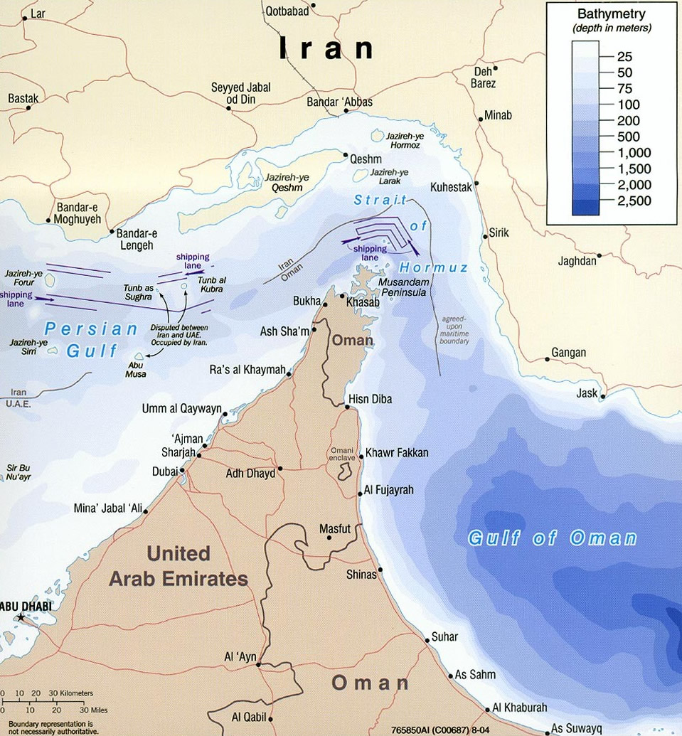
Correct — A, The Persian Gulf to Gulf of Oman. The Strait of Hormuz is the single sea outlet of the Persian Gulf: Iran holds the northern shore, while the southern shore is Oman's Musandam Peninsula, with a small stretch belonging to the UAE. At its narrowest the strait is only 39 km (24 miles, 21 nautical miles) across. Because the navigable channel is so tight, traffic runs on an International Maritime Organization Traffic Separation Scheme — an inbound lane and an outbound lane, each 2 nautical miles (3.7 km) wide, kept apart by a median strip of the same width — and those lanes lie inside Omani territorial waters, which is why the strait is a legal as well as a physical chokepoint. The volumes involved are the reason it is in the news at all: about 21 million barrels of oil a day passed through it in 2018, and across 2023–25 it carried roughly 25 per cent of seaborne oil trade, making it the world's most important oil chokepoint. Geographically the chain reads Persian Gulf → Strait of Hormuz → Gulf of Oman → Arabian Sea → Indian Ocean, and it matters that the Gulf has no second exit: every cargo loaded in Iran, Iraq, Kuwait, Saudi Arabia, Bahrain, Qatar or the UAE must sail out through Hormuz. That absence of an alternative is precisely why any threat to close the strait moves world crude prices within hours, and why the option pairs it with the Gulf of Oman rather than with any open ocean — the Gulf of Oman is the body of water immediately outside it, before the Arabian Sea widens out.
Why the others are wrong
- (b)Red sea to Gulf of Aden — That is Bab-el-Mandeb, the strait at the southern end of the Red Sea between Djibouti and Eritrea on the African side and Yemen on the Arabian side. It tempts because it is the *other* great chokepoint of the same region and is discussed in the same breath as Hormuz whenever shipping is disrupted — but it is a Red Sea feature, not a Persian Gulf one.
- (c)Red sea to Indian Ocean — The statement is loosely true of the Red Sea — it does reach the Indian Ocean — but the link is made by Bab-el-Mandeb and then the Gulf of Aden and the Arabian Sea, not by Hormuz. This option catches candidates who know only that Hormuz opens 'towards the Indian Ocean' and never fixed which enclosed sea sits at the other end of it.
- (d)Mediterranean sea to Red sea — That is the Suez Canal — and it is not a strait at all but a man-made, lock-free, sea-level canal 193.30 km long across the Isthmus of Suez, opened on 17 November 1869. The option is designed for candidates who file all four Middle Eastern waterways under one heading; the first check on any such question is whether the thing named is a natural strait or a dug canal.
Concept
A strait is a narrow natural channel of water that joins two larger water bodies and, in doing so, separates two land masses — the exact mirror image of an isthmus, which is a narrow neck of land joining two land masses and separating two water bodies. Where nature provided no strait, states have dug a canal instead: Suez (1869) across the Isthmus of Suez and Panama (1914) across the Isthmus of Panama. Straits that carry a large share of world trade through a very small cross-section are called chokepoints, and a short list covers most of them: Hormuz (Persian Gulf–Gulf of Oman), Bab-el-Mandeb (Red Sea–Gulf of Aden), Malacca (Andaman Sea–South China Sea), the Turkish Straits of Bosporus and Dardanelles (Black Sea–Mediterranean), the Danish Straits, and the two great artificial ones, Suez and Panama. The Persian Gulf is a shallow, almost land-locked arm of the Arabian Sea bordered by Iran and by Iraq, Kuwait, Saudi Arabia, Bahrain, Qatar, the UAE and Oman; because Hormuz is its only opening, the strait converts a regional waterway into a global one.
The reasoning shortcut here is to notice how the options are built. Three of the four — (b), (c) and (d) — are all statements about the Red Sea chain, and only (a) belongs to the Persian Gulf chain. Fix the two chains separately and the question collapses. Chain one: Mediterranean Sea →(Suez Canal)→ Red Sea →(Bab-el-Mandeb)→ Gulf of Aden → Arabian Sea. Chain two: Persian Gulf →(Strait of Hormuz)→ Gulf of Oman → Arabian Sea. Hormuz appears only in the second chain, so any option mentioning the Red Sea can be struck at once, which leaves (a) standing without needing to recall a single figure. A second, independent check is the name itself. The strait takes its name from Hormuz — the medieval harbour town, and the Iranian island in Hormozgan province that inherited the name when the town's ruler moved onto it around 1300 — a principality that straddled both sides of the strait and was seized by the Portuguese in 1507. The name therefore belongs to the mouth of the Persian Gulf, so the Gulf has to be one of the two water bodies the strait joins. The single fact that discriminates, if you remember nothing else, is that the Persian Gulf has exactly one exit and its name is Hormuz.
Key facts
- Narrowest width 39 km (24 miles / 21 nautical miles); Iran on the northern shore, Oman's Musandam Peninsula with a small UAE portion on the southern shore.
- Traffic runs on a Traffic Separation Scheme of inbound and outbound lanes, each 2 nautical miles (3.7 km) wide with a median strip between them, and the lanes lie inside Omani territorial waters.
- About 21 million barrels of oil a day transited the strait in 2018, and it carried roughly 25 per cent of seaborne oil trade over 2023–25 — the world's foremost oil chokepoint.
- It is Bab-el-Mandeb, between Djibouti/Eritrea and Yemen, that links the Red Sea to the Gulf of Aden; the Suez Canal — 193.30 km across the Isthmus of Suez, opened 17 November 1869, sea-level and lock-free, with a 35 km parallel channel opened on 6 August 2015 — links the Mediterranean to the Red Sea.
- The Persian Gulf has no second outlet. Its littoral states are Iran, Iraq, Kuwait, Saudi Arabia, Bahrain, Qatar, the UAE and Oman, and every cargo they ship by sea must clear Hormuz. The strait is named after Hormuz, the medieval harbour town and the Iranian island in Hormozgan province that took over the name around 1300 and was captured by the Portuguese in 1507.
Study next
Common traps
- Confusing Hormuz with Bab-el-Mandeb — both are West Asian oil chokepoints, but one gates the Persian Gulf and the other the Red Sea
- Treating the Suez Canal as a strait; it is an artificial canal across the Isthmus of Suez, which is why option (d) is wrong twice over
- Answering 'Arabian Sea' or 'Indian Ocean' for the outer end. The water body immediately outside Hormuz is the Gulf of Oman; the Arabian Sea comes after it
BPSC asks the bare connectivity fact — 'X connects —' with four sea pairs — so the whole question is one line of recall. UPSC almost never asks it that flatly; it hides the same knowledge inside a route or an economics frame, such as which strait a tunnel between the UK and France runs beneath (2007), what one would see travelling through the Malacca Strait (2010), or which destination from Mumbai does not require passing through the Suez Canal (1997).
Related PYQs
Through which one of the following Straits does a tunnel connect the United Kingdom and France?
- (a) Davis Strait
- (b) Denmark Strait
- (c) Strait of Dover
- (d) Strait of Gibraltar
Answer(c) Strait of Dover
The same skill in the same subject — pin a named strait to the two things it lies between, with three other real straits offered as look-alikes.
One will NOT have to pass through the Suez Canal while going from Mumbai to
- (a) Alexandria
- (b) Suez
- (c) Port Said
- (d) Benghazi
Answer(b) Suez
Tests the waterway offered here as distractor (d): the Suez Canal joins the Mediterranean to the Red Sea, and knowing which end of it a port sits at is exactly the discrimination this BPSC option demands.
Which one of the following can one come across if one travels through the Strait of Malacca?
- (a) Bali
- (b) Brunei
- (c) Java
- (d) Singapore
Answer(d) Singapore
The other great Asian chokepoint, asked the same way — you cannot answer it without knowing which two water bodies Malacca joins and which coasts it runs between, which is the whole content of the Hormuz question.
Practice
- practice — not a real PYQ
The Bab-el-Mandeb strait connects the Red Sea to which of the following?
- (a)Persian Gulf
- (b)Gulf of Aden
- (c)Mediterranean Sea
- (d)Gulf of Oman
Answer(b) Gulf of Aden — Bab-el-Mandeb lies at the southern end of the Red Sea, between Djibouti/Eritrea and Yemen. - practice — not a real PYQ
The Musandam Peninsula, which forms the southern shore of the Strait of Hormuz, belongs mainly to which country?
- (a)Iran
- (b)Oman
- (c)Qatar
- (d)Saudi Arabia
Answer(b) Oman — the peninsula is Omani territory, and the strait's shipping lanes run inside Omani territorial waters.