
Zoji-la Tunnel will connect which of the following places ?
- (a)Manali and Lahaul Spiti valley
- (b)Manali and Jammu
- (c)Srinagar and Jammu
- (d)Srinagar and Leh
Answer
Why
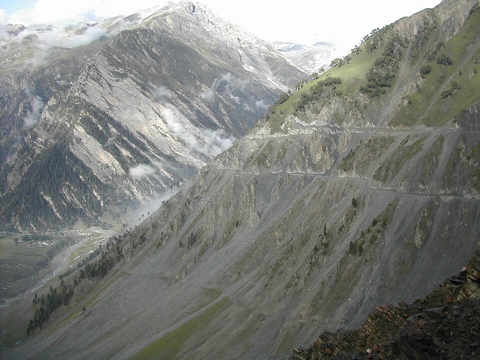
Correct: D, Srinagar and Leh. Zoji La is the pass at about 3,580 metres on National Highway 1 between Srinagar and Leh, linking the Kashmir Valley on its west to the Dras and Suru valleys to its north-east and the Indus valley beyond. It is the choke point of that entire corridor: heavy snow shuts it through the winter months, and when it is shut, Ladakh's only reliable land route to the rest of the country is severed. The tunnel is being driven beneath the pass precisely to remove that seasonal break: a bore of about 14 kilometres, approved in January 2018, with construction inaugurated by the Prime Minister in May 2018 at a cost of the order of 930 million US dollars, and projected when complete to be the longest bidirectional tunnel in Asia. The headline gain is time as well as reliability: crossing the pass currently takes over three hours and the tunnel is expected to reduce it to about fifteen minutes. All three wrong options name real tunnel corridors, which is what makes the question a genuine test rather than a giveaway: Manali to Lahaul-Spiti is the Atal Tunnel under the Rohtang Pass, opened in October 2020, and Srinagar to Jammu is served by the Jawahar Tunnel under the Banihal Pass and by the newer tunnels on the NH-44 alignment. Only one corridor runs through Zoji La, and that is Srinagar to Leh.
Why the others are wrong
- (a)Manali and Lahaul Spiti valley: That is the Atal Tunnel, bored under the Rohtang Pass in Himachal Pradesh and opened in October 2020, which gives Lahaul-Spiti all-weather access from Manali. Same idea (a tunnel replacing a snowbound pass) but a different state, a different pass and a different highway.
- (b)Manali and Jammu: Not a corridor at all. Manali is in Himachal Pradesh and Jammu in the Jammu region; no single tunnel connects them, and the two lie on separate highway systems. The option works only by borrowing 'Manali' from one real answer and 'Jammu' from another.
- (c)Srinagar and Jammu: A real and heavily tunnelled corridor, but a different one: NH-44, where the Jawahar Tunnel under the Banihal Pass and the newer Chenani–Nashri and Banihal–Qazigund tunnels carry traffic between the Jammu region and the Kashmir Valley. Zoji La lies beyond Srinagar, on the road onward to Ladakh.
Concept
Ladakh's connectivity problem is a matter of passes. Two road routes reach Leh: the Srinagar–Kargil–Leh road on NH-1, which must cross Zoji La at about 3,580 metres, and the Manali–Leh road, which crosses several passes higher still. Both close under snow for a large part of the year, which has historically left Ladakh reachable only by air in winter: a serious matter for a region with a long disputed frontier and a permanent military presence. India's answer has been a programme of high-altitude tunnelling that replaces a pass crossing with a bore beneath it: the Atal Tunnel under Rohtang on the Manali axis, opened in 2020; the Zojila tunnel on the Srinagar axis, under construction; and the Sela tunnel in Arunachal Pradesh on the road to Tawang. Each converts a road that is seasonal into one that is all-weather, cuts hours from the journey and removes the avalanche risk of the open pass. The same logic drove the tunnels on the Jammu–Srinagar highway, which is why that corridor supplies this question's most plausible distractor.
Tunnel and pass questions are best held as a table of three columns (the tunnel, the pass it goes under, and the two places it joins) because examiners scramble exactly those three. Fix the pass first: Zoji La is on the Srinagar to Leh road, Rohtang is on the Manali to Lahaul-Spiti road, and Banihal is on the Jammu to Srinagar road. Once the pass is placed, the option follows without any need to recall the tunnel's length or cost. A useful cross-check is the highway number, since NH-1 in the current numbering runs Srinagar–Uri and the Srinagar–Leh axis is the one Zoji La sits on, while the Jammu–Srinagar corridor is NH-44. Notice also how option (b) is built: it takes a place from one true pairing and a place from another, which is a standard way of manufacturing a fourth option in this format. If a pairing does not correspond to any corridor you can trace on a map, it is usually a composite rather than something you have simply forgotten.
Key facts
- Zoji La is a pass at about 3,580 metres on National Highway 1, on the Srinagar–Leh road; it connects the Kashmir Valley with the Dras and Suru valleys and the Indus valley beyond
- The Zojila tunnel is about 14 kilometres long, approved in January 2018 and inaugurated for construction by the Prime Minister in May 2018, at a cost of the order of 930 million US dollars
- When complete it is projected to be the longest bidirectional tunnel in Asia and to cut the crossing from over three hours to about fifteen minutes
- The pass is closed by snow for months each winter, which is what makes the tunnel a strategic as well as a civilian project for Ladakh
- The Atal Tunnel under the Rohtang Pass, opened in October 2020, is the one that connects Manali with the Lahaul-Spiti valley
- The Jammu–Srinagar corridor on NH-44 is served by the Jawahar Tunnel under the Banihal Pass and by the newer Chenani–Nashri and Banihal–Qazigund tunnels
Study next
Common traps
- Confusing the Zojila tunnel with the Atal Tunnel; the first serves Srinagar to Leh, the second Manali to Lahaul-Spiti
- Choosing Srinagar–Jammu, which is a genuine and heavily tunnelled corridor but on NH-44, not through Zoji La
- Being drawn to composite options such as Manali–Jammu, which pair two places that no single corridor connects
BPSC asks infrastructure as a simple 'X connects which two places' identification and builds the distractors from other real projects in the same region, so a short table of tunnel, pass and corridor is worth more than the technical specifications. UPSC asks the same geography either as pairs to be matched (highway against the cities it links) or through the strategic angle, such as which pass was reopened for trade with China, so the passes need to be known with their diplomatic and military significance attached.
Related PYQs
Consider the following pairs: National Highway - Cities connected 1. NH 4 - Chennai and Hyderabad 2. NH 6 - Mumbai and Kolkata 3. NH 15 - Ahmedabad and Jodhpur Which of the above pairs is/are correctly matched?
- (a) 1 and 2 only
- (b) 3 only
- (c) 1, 2 and 3
- (d) None
Answer(d) None
The identical skill (a route matched to the two places it actually joins) and a reminder that plausible-looking pairings of real cities and real highways are usually manufactured.
Which one of the following Himalayan passes was reopened in the middle of the year 2006 to facilitate trade between India and China?
- (a) Chang La
- (b) Jara La
- (c) Nathu La
- (d) Shipki La
Answer(c) Nathu La
Himalayan passes tested as the strategic assets they are: the same family of place-names, and the same requirement to know which route each one carries.
Strait of Hormuz connects -
- (a) The Persian Gulf to Gulf of Oman
- (b) Red sea to Gulf of Aden
- (c) Red sea to Indian Ocean
- (d) Mediterranean sea to Red sea
Answer(a) The Persian Gulf to Gulf of Oman
The Commission's exact template repeated on the next paper: a named choke point and four candidate pairs of places, with every wrong option naming two real but unconnected water bodies.
Practice
- practice, not a real PYQ
The Atal Tunnel, opened in October 2020, passes under which mountain pass ?
- (a)Zoji La
- (b)Rohtang Pass
- (c)Banihal Pass
- (d)Sela Pass
Answer(b) Rohtang Pass: it gives Manali all-weather access to the Lahaul-Spiti valley in Himachal Pradesh; Zoji La is on the Srinagar–Leh road and Banihal on the Jammu–Srinagar road. - practice, not a real PYQ
Zoji La pass lies on which National Highway ?
- (a)NH-1
- (b)NH-44
- (c)NH-3
- (d)NH-7
Answer(a) NH-1: the Srinagar–Kargil–Leh axis; NH-44 is the Jammu–Srinagar corridor with the Jawahar and Chenani–Nashri tunnels.