
Match List – I with List – II and select the correct answer from the code given below the lists. List – I (Hill/Mountain) A. Bateshwar Hill B. Bilari Range C. Chin Range D. Dhoshi Hill List – II (Location in State of India) 1. Haryana 2. Manipur 3. Bihar 4. Karnataka Code :
- (a)A-3, B-2, C-4, D-1
- (b)A-4, B-3, C-1, D-2
- (c)A-2, B-3, C-1, D-4
- (d)A-3, B-4, C-2, D-1
Answer
Why
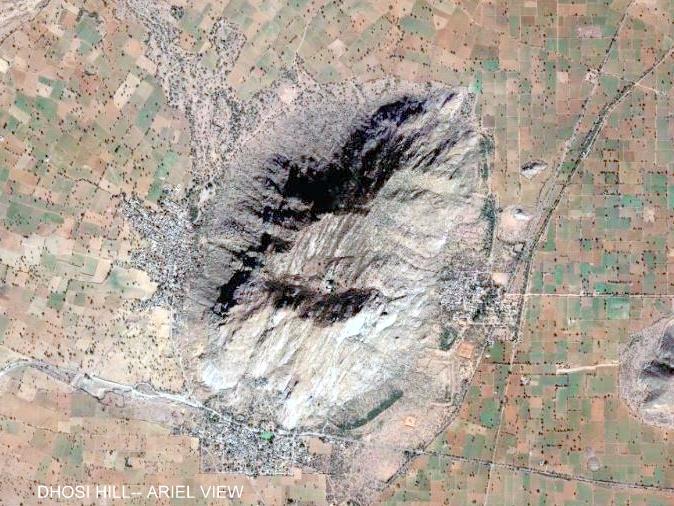
Correct — D, A-3, B-4, C-2, D-1. The commission's key reads Bateshwar Hill – Bihar, 'Bilari Range' – Karnataka, Chin Range – Manipur, Dhoshi Hill – Haryana. Two of those four are firmly documented and they are enough to close the question. The CHIN RANGE (the Chin Hills) runs through Chin State in north-western Myanmar and extends northward into India's Manipur — it belongs to the eastern, Patkai-Naga system along with the Lushai Hills, so C-2 is secure. DHOSI HILL is an isolated hill on the Haryana–Rajasthan border: Mahendragarh district lies on the Haryana side and Jhunjhunu district on the Rajasthan side, and it is conventionally listed under Haryana, so D-1 is secure. Fix those two and only option (d) survives, because it is the only code that carries both C-2 and D-1. The remaining two pairs follow by elimination: Bateshwar Hill takes Bihar (3) and 'Bilari Range' takes Karnataka (4). Be honest about those two, though. 'Bateshwar Hill' most likely refers to the Bateshwar (Batesar) hills near Kahalgaon in Bhagalpur district, Bihar — a rock-cut Buddhist and Hindu site above the Ganga — but the attribution is not something we could confirm from a standard reference, and there are similarly named places at Bateshwar in Agra district (Uttar Pradesh) and Batesar in Morena (Madhya Pradesh). 'BILARI RANGE' is worse: no range of that name is documented in Karnataka at all. The name the examiner appears to intend is the BILIGIRIRANGAN (BR) Hills of Chamarajanagar district in Karnataka, of which 'Bilari' looks like a corruption; note also that Bilari is separately a town in Moradabad district, Uttar Pradesh. Treat B-4 as the examiner's intention rather than as an established toponym.
Why the others are wrong
- (a)A-3, B-2, C-4, D-1 — Gets Bateshwar–Bihar and Dhoshi–Haryana right but swaps the middle pair: it sends the Chin Range to Karnataka and the Karnataka range to Manipur. The Chin Range is unambiguously a north-eastern feature, continuous with Myanmar's Chin Hills, so it cannot sit in peninsular Karnataka.
- (b)A-4, B-3, C-1, D-2 — Every pair is displaced. It puts the Chin Range in Haryana — a state with no hill system of that kind at all — and Dhoshi Hill in Manipur, which is the reverse of the two pairs that are actually documented.
- (c)A-2, B-3, C-1, D-4 — Also fails on the two secure pairs: the Chin Range is placed in Haryana and Dhoshi Hill in Karnataka. Either error alone is enough to eliminate the code.
Concept
Hill-to-State matching questions are decided by regional systems, not by memorising every name. India's hills fall into recognisable families: the Himalayan and trans-Himalayan ranges in the north; the eastern Patkai–Naga–Chin–Lushai arc curving down the Indo-Myanmar border through Manipur and Mizoram; the Aravalli outliers scattered across Haryana and Rajasthan; the Vindhya–Satpura–Kaimur belt across central India; and the Western and Eastern Ghats in the peninsula. Place a name in its family and the State usually follows.
The efficient route here is not to know all four names but to lock the two you can defend and let the code do the rest. 'Chin' is an Indo-Myanmar border name, so it goes to the north-eastern State on the list, Manipur. 'Dhoshi' is a north-western outlier name, so it goes to Haryana. Only one of the four codes carries both, and that is the key. This is also a question worth flagging for what it teaches about UPPSC's proofreading: the printed name 'Bilari Range' does not correspond to any documented range in Karnataka, and a candidate who spent the exam hunting for it was hunting for something that is not there.
Key facts
- The Chin Hills lie in Chin State, north-western Myanmar, and extend northward into India's Manipur; with the Lushai Hills they form the eastern part of the Patkai system.
- Dhosi Hill straddles the Haryana–Rajasthan boundary — Mahendragarh district (Haryana) on one side, Jhunjhunu district (Rajasthan) on the other — and is conventionally listed under Haryana.
- Dhosi Hill is also an old Vedic and Puranic site, associated in tradition with the rishi Chyavana and with Chyawanprash.
- 'Bilari Range' is not a standard toponym: no range of that name is documented in Karnataka. The Biligirirangan (BR) Hills of Chamarajanagar district are the probable referent, and Bilari is separately a town in Moradabad district, Uttar Pradesh.
Study next
Common traps
- Trying to answer a match-list by resolving all four pairs. Two secure pairs almost always leave a single surviving code.
- Assuming every printed name in a State PSC paper is a standard toponym. 'Bilari Range' is not one — do not lose time verifying it inside the exam hall.
- Confusing Bateshwar in Bihar with Bateshwar in Agra district (Uttar Pradesh) or Batesar in Morena (Madhya Pradesh) — three unrelated places sharing a name.
UPPSC prefers the four-pair match-list code for hills and ranges, while UPSC more often asks 'which of the following pairs is/are correctly matched' or a straight 'where are the X Hills located' — the same knowledge tested through a different wrapper.
Related PYQs
Consider the following pairs: Hills : Region 1. Cardamom Hills : Coromandel Coast 2. Kaimur Hills : Konkan Coast 3. Mahadeo Hills : Central India 4. Mikir Hills : North-East India Which of the above pairs are correctly matched?
- (a) 1 and 2
- (b) 2 and 3
- (c) 3 and 4
- (d) 2 and 4
Answer(c) 3 and 4
The identical skill — placing a named hill group in the right part of India — in UPSC's preferred pair-checking format. Note the same solving method works: recognising Mikir as a north-eastern name and Mahadeo as a Satpura name settles the question without touching the other two.
Where are the Shevaroy Hills located?
- (a) Andhra Pradesh
- (b) Karnataka
- (c) Kerala
- (d) Tamil Nadu
Answer(d) Tamil Nadu
The single-pair version of this question: a lesser-known Eastern Ghats block matched to its State. Worth attempting alongside the Biligirirangan Hills, which are the range the 2022 paper appears to have garbled.
Which one of the following peaks is NOT located in India ?
- (a) Gurla Mandhata
- (b) Namcha Barwa
- (c) Kamet
- (d) Nanga Parbat
Answer(a) Gurla Mandhata
UPPSC's other way of testing the same table — instead of pairing a hill with its State, it asks which named summit falls outside India altogether. Both items reward a candidate who carries a mental map of named highlands rather than a list of heights.
Consider the following mountains and arrange them in correct order from West to East by their location : 1. Karakoram 2. Pontic 3. Hindu Kush 4. Zagros Select the correct answer from the codes given below :
- (a) 2, 4, 3, 1
- (b) 2, 3, 4, 1
- (c) 4, 2, 3, 1
- (d) 4, 1, 2, 3
Answer(a) 2, 4, 3, 1
The commission repeatedly asks candidates to locate named ranges, whether by State (2022) or by longitude (2024). The habit that pays in both is attaching every range name to a system and a region the moment you first meet it.
Practice
- practice — not a real PYQ
The Chin Hills form part of which of the following mountain systems?
- (a)The Aravalli system
- (b)The Purvanchal (Patkai) system along the Indo-Myanmar border
- (c)The Satpura system of central India
- (d)The Eastern Ghats
Answer(b) The Purvanchal (Patkai) system along the Indo-Myanmar border — the Chin Hills lie mainly in Chin State, Myanmar, and extend north into Manipur, forming the eastern arc with the Naga and Lushai Hills. - practice — not a real PYQ
Dhosi Hill, associated in tradition with the rishi Chyavana, lies on the border of which two States?
- (a)Haryana and Rajasthan
- (b)Punjab and Himachal Pradesh
- (c)Rajasthan and Gujarat
- (d)Madhya Pradesh and Uttar Pradesh
Answer(a) Haryana and Rajasthan — Mahendragarh district on the Haryana side and Jhunjhunu district on the Rajasthan side; it is conventionally listed under Haryana.