
Which one of the following peaks is NOT located in India ?
- (a)Gurla Mandhata
- (b)Namcha Barwa
- (c)Kamet
- (d)Nanga Parbat
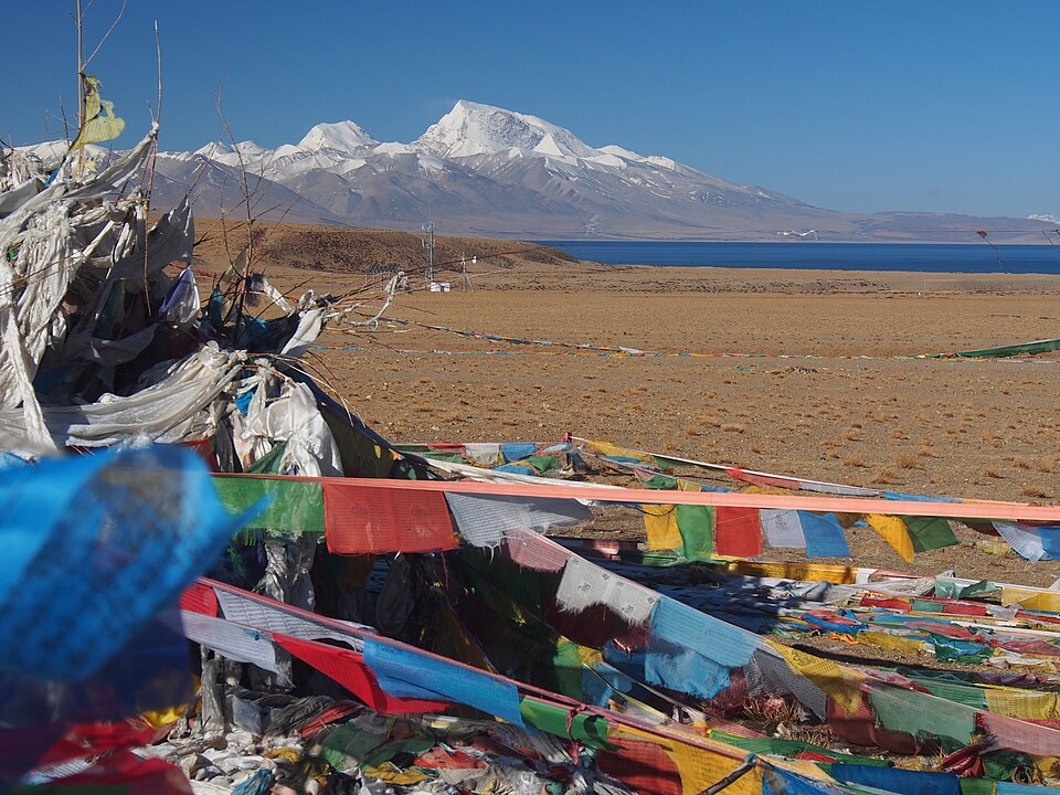
Correct — A, Gurla Mandhata. Gurla Mandhata (locally Naimona'nyi), about 7,694 m, is the highest summit of the Nalakankar Himal and stands in Burang county of Ngari prefecture in the Tibet Autonomous Region of China, rising just south of the twin lakes Manasarovar and Rakshastal on the Kailash pilgrimage route. It lies entirely beyond the Himalayan crest inside Tibet: India has never claimed it, no Indian map shows it within Indian territory, and it belongs to no Indian state. That is what makes it the clean answer here — of the four peaks it is the only one with no Indian claim of any kind attached to it. Kamet is in Uttarakhand; Nanga Parbat lies in Gilgit-Baltistan, which India claims as part of Jammu and Kashmir and shows within its own boundary; and Namcha Barwa, although across the line in Tibet, is treated in Indian physical geography as the eastern anchor of the Himalayan system on India's Arunachal frontier.
- (b)Namcha Barwa — Namcha Barwa (about 7,782 m) is the peak around which the Tsangpo swings through its Great Bend before entering Arunachal Pradesh as the Siang. Indian physical geography learns it as the eastern anchor or eastern terminus of the Himalayan range — the counterpart of Nanga Parbat in the west — and treats it as part of the Indian Himalayan framework, so it is not the peak the examiner is pointing at. Be honest about the geography, though: Namcha Barwa itself stands inside Tibet, which is why this option feels arguable (see the traps below).
- (c)Kamet — Kamet (about 7,756 m) is squarely inside India — in Chamoli district of Uttarakhand, in the Zaskar range close to the Tibet border, and the second-highest peak of Uttarakhand after Nanda Devi. There is no dispute about it at all.
- (d)Nanga Parbat — Nanga Parbat (8,126 m), the ninth-highest mountain on earth, towers above the Indus gorge as the western anchor of the Himalaya. It lies in Gilgit-Baltistan, which is under Pakistan's administration but which India claims as part of the erstwhile state of Jammu and Kashmir and depicts inside its own boundary; Indian textbooks and examiners therefore count it among Indian peaks.
The Himalayan arc is conventionally described between two anchor peaks — Nanga Parbat in the west, where the Indus cuts through, and Namcha Barwa in the east, where the Tsangpo turns south. North of that arc lies the Trans-Himalaya and the Tibetan plateau, home to the Kailash range and to Gurla Mandhata beside Lake Manasarovar. Placing a peak therefore means asking two separate questions: which range does it belong to, and on which side of the international boundary does it stand? Gurla Mandhata answers both against India — Tibetan side, Tibetan territory.
The question is really about the boundary, not about altitude. Run down the list looking for the peak that no Indian state can claim: Kamet has an address in Chamoli, Nanga Parbat has one in the Indian-claimed Gilgit-Baltistan, Namcha Barwa is taught as the range's eastern end-post on India's north-eastern frontier — and Gurla Mandhata has an address only in Tibet, beside Manasarovar. That is the peak the examiner wants. Notice that this is one of those Indian-geography items where more than one option can be argued; the strongest and intended reading is the peak with no Indian connection whatsoever.
- Gurla Mandhata (Naimona'nyi), about 7,694 m — highest peak of the Nalakankar Himal, in Burang county, Ngari prefecture, Tibet Autonomous Region, China.
- It rises just south of Lake Manasarovar and Rakshastal, across the valley from Mount Kailash.
- Kamet, about 7,756 m — Chamoli district, Uttarakhand; the second-highest peak of the state after Nanda Devi.
- Nanga Parbat, 8,126 m — the western anchor of the Himalaya above the Indus gorge, in Gilgit-Baltistan, claimed by India as part of Jammu and Kashmir.
- Namcha Barwa, about 7,782 m — the eastern anchor of the Himalaya at the Tsangpo Great Bend, in Nyingchi, Tibet, just beyond Arunachal Pradesh.
- This item is fuzzier than it looks, and it is worth knowing why. Namcha Barwa physically stands inside Tibet, so a student who reads the question as a pure territory test can defend option (b) as well. Indian geography texts nevertheless present it as the eastern end-post of the Himalayan range on India's Arunachal frontier, and the examiner's target is the peak that carries no Indian association at all — Gurla Mandhata, in the Tibetan interior beside Manasarovar. Argue from that distinction, not from altitude.
- Nanga Parbat raises the mirror-image doubt: it is administered by Pakistan, so 'not located in India' can be argued for it too. India's official position is that Gilgit-Baltistan is part of Jammu and Kashmir, and Indian examinations follow India's official map — so in an Indian paper Nanga Parbat counts as Indian.
- Do not sort the options by height. Nanga Parbat is by far the tallest of the four and Gurla Mandhata the shortest, which tempts candidates into a guess that has nothing to do with the question.
UPPSC asks this as a straight 'which peak is not in India / which state is this peak in' recall item; UPSC prefers to bury the same knowledge inside pair-matching — peak with mountain range, or peak with state — as it did in 2022 with Namcha Barwa itself.
Consider the following pairs: Peak — Mountains 1. Namcha Barwa — Garhwal Himalaya 2. Nanda Devi — Kumaon Himalaya 3. Nokrek — Sikkim Himalaya Which of the pairs given above is/are correctly matched?
- (a) 1 and 2
- (b) 2 only
- (c) 1 and 3
- (d) 3 only
Answer(b) 2 only
UPSC tested exactly the same knowledge three years later, and even used Namcha Barwa as its trap — you clear both papers by knowing that Namcha Barwa belongs to the extreme eastern Himalaya, not the Garhwal.
Nanda Devi peak forms a part of
- (a) Assam Himalayas
- (b) Kumaon Himalayas
- (c) Nepal Himalayas
- (d) Punjab Himalayas
Answer(b) Kumaon Himalayas
The same drill of locating a named Himalayan summit within a defined section of the range — Nanda Devi and Kamet are neighbours in the Kumaon-Garhwal Himalaya of Uttarakhand.
Match List-I with List-II and select the correct answer using the codes given below the lists. List-I (State of India) A. Tamil Nadu B. Rajasthan C. Nagaland D. Madhya Pradesh List-II (Highest Peak) 1. Dhupgarh Peak 2. Saramati Peak 3. Gurushikhar Peak 4. Dodda Betta Peak
- (a) A-3 B-2 C-1 D-4
- (b) A-1 B-4 C-3 D-2
- (c) A-4 B-2 C-3 D-1
- (d) A-4 B-3 C-2 D-1
Answer(d) A-4 B-3 C-2 D-1
UPPSC returned two years later to the same idea — pinning named peaks to their exact political location — this time inside India rather than across the frontier.
- practice — not a real PYQ
Which peak is described as the western anchor of the Himalayan range, rising above the gorge where the Indus cuts through the mountains?
- (a)Nanga Parbat
- (b)Namcha Barwa
- (c)Kamet
- (d)Gurla Mandhata
Answer(a) Nanga Parbat — at 8,126 m it marks the western end of the Himalayan arc above the Indus gorge, while Namcha Barwa marks the eastern end at the Tsangpo Great Bend.
- practice — not a real PYQ
Gurla Mandhata, the highest peak of the Nalakankar Himal, overlooks which pair of lakes?
- (a)Manasarovar and Rakshastal
- (b)Pangong Tso and Tso Moriri
- (c)Wular and Dal
- (d)Loktak and Chilika
Answer(a) Manasarovar and Rakshastal — the peak stands just south of the two lakes in western Tibet, across the valley from Mount Kailash.