
Famous 'Ruhr coalfield' is situated in which of the following countries ?
- (a)Germany
- (b)France
- (c)Great Britain
- (d)Russia
Answer
Why
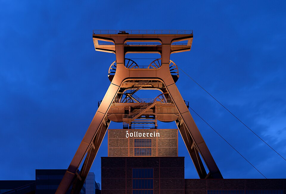
Correct — A, Germany. The Ruhr, or Ruhrgebiet, lies in the German state of North Rhine-Westphalia, within the Rhine-Ruhr conurbation, and takes its name from the river Ruhr, a right-bank tributary of the Rhine. Its coal was the foundation of Germany's industrial rise: the seams were worked at scale from the mid-nineteenth century, the coal was coked to feed blast furnaces, and the result was the classic coal-and-steel belt of Essen, Dortmund, Duisburg, Bochum and Gelsenkirchen, home to Krupp and Thyssen. By 1870 over three million people lived in the Ruhrgebiet and it had become Europe's largest industrial region. Its later history is just as useful to know. Because coal and steel were the sinews of war, the Ruhr was the object of the Franco-Belgian occupation of 1923 and, after 1945, of the International Authority for the Ruhr — an arrangement that fed directly into the European Coal and Steel Community of 1951 and so into the origins of the European Union. From 1958 demand fell away, the accessible seams were exhausted and German coal ceased to be competitive, beginning decades of structural change; the Zollverein colliery at Essen, once the region's largest, is today a UNESCO World Heritage site.
Why the others are wrong
- (b)France — France's historic coal-mining region is the Nord-Pas-de-Calais basin in the far north, not the Ruhr. The confusion is understandable because the two lie in the same industrial belt of north-west Europe and because France occupied the Ruhr in 1923 to enforce reparations — but occupying a coalfield is not the same as owning one.
- (c)Great Britain — Britain's coalfields carry their own names — Lancashire, Yorkshire, Northumberland-Durham and South Wales among them. Britain industrialised on coal earlier than Germany did, which makes it a tempting answer for a question about a 'famous' coalfield, but the Ruhr is not one of its fields.
- (d)Russia — Russia's principal coal basins are the Kuznetsk (Kuzbass) in south-western Siberia and the Pechora in the far north; the Donets basin, or Donbas, lies largely in Ukraine. None of them is the Ruhr, which is several thousand kilometres to the west.
Concept
The world's great nineteenth-century industrial regions grew where coal could be mined cheaply and moved cheaply, because coking coal was needed in bulk to smelt iron. The Ruhr is the textbook case: coal seams under a navigable river basin, close to the Rhine and so to the North Sea ports, with iron ore brought in by water. That combination produced Europe's densest concentration of collieries, coke ovens, blast furnaces and rolling mills, and with them a conurbation of cities that grew into one another. The pattern repeats elsewhere — the Appalachian field in the United States, Lancashire and Yorkshire in England, the Donets basin in Ukraine, the Kuznetsk basin in Russia, and the Damodar valley in India. When such regions decline, they decline together, because the whole industrial complex rests on one resource: the Ruhr's contraction after 1958 is the standard example of the de-industrialisation and structural-change problem, of which the reinvention of Zollverein colliery as a World Heritage site is the visible symbol.
This is a straight recall question, but it can be reasoned if the name is unfamiliar. 'Ruhr' is a German word and a German river, and the option list conveniently contains exactly one German-speaking country. More usefully, learn the coalfields by country as a set rather than one at a time, because UPPSC prefers to ask them as match lists: Appalachian with the United States, Lancashire with England, Ruhr with Germany, Kuzbass with Russia. Once the set is fixed, both the single-answer and the match-list versions collapse into recall of the same four pairs. A caution on the distractors: all three wrong options are genuine coal-producing countries with famous fields of their own, so eliminating them requires knowing their fields by name — Nord-Pas-de-Calais for France, Lancashire and Yorkshire for Britain, Kuznetsk and Pechora for Russia — rather than merely knowing that the Ruhr is not theirs.
Key facts
- The Ruhr (Ruhrgebiet) lies in North Rhine-Westphalia, Germany, within the Rhine-Ruhr conurbation, and is named after the river Ruhr.
- By 1870 the Ruhrgebiet had over three million inhabitants and was Europe's largest industrial region, built on coal coked to feed blast furnaces — Essen, Dortmund, Duisburg, Bochum and Gelsenkirchen, with Krupp and Thyssen.
- The Ruhr was occupied by France and Belgium in 1923, and after 1945 was placed under the International Authority for the Ruhr, which led into the European Coal and Steel Community of 1951.
- From 1958 demand fell, accessible seams were exhausted and German coal lost competitiveness, beginning decades of structural change; the Zollverein colliery at Essen is now a UNESCO World Heritage site.
- The distractor countries have coalfields of their own: Nord-Pas-de-Calais in France; Lancashire, Yorkshire, Northumberland-Durham and South Wales in Britain; the Kuznetsk and Pechora basins in Russia.
Study next
Common traps
- Reading the 1923 Franco-Belgian occupation as evidence that the Ruhr is French — it was occupied, not owned
- Assuming any famous European coalfield must be British because Britain industrialised first
- Placing the Donets basin (Donbas) in Russia; it lies largely in Ukraine, while Russia's own major fields are the Kuznetsk and Pechora basins
UPPSC asks world coalfields either as a one-line country question, as here, or as a four-way match list of field against country — and it has used the Ruhr in both formats. UPSC prefers Indian coalfields and asks them by location or by their bearing on steel-plant siting. Learning the fields as country-wise sets covers both.
Related PYQs
In which one of the following States are Namchik-Namphuk Coalfields located?
- (a) Arunachal Pradesh
- (b) Meghalaya
- (c) Manipur
- (d) Mizoram
Answer(a) Arunachal Pradesh
The same skill on the Indian map: a named coalfield, four candidate locations, and marks for having learnt the field-to-place pairing. UPPSC sets it at world scale, UPSC at national scale, and both reward the same coalfield atlas.
Match List - I with List - II and choose the correct answer by using the code given below the lists. List - I (Coal Field) A. Appalachian B. Lancashire C. Ruhr D. Kuzbass List - II (Country) 1. England 2. Germany 3. Russia 4. United States of America
- (a) A-4, B-1, C-2, D-3
- (b) A-1, B-4, C-2, D-3
- (c) A-1, B-4, C-3, D-2
- (d) A-4, B-1, C-3, D-2
Answer(a) A-4, B-1, C-2, D-3
The same fact three years later, embedded in a four-way match list — Ruhr again pairs with Germany, alongside Appalachian with the United States, Lancashire with England and Kuzbass with Russia. Learning the four pairs together answers both papers.
Practice
- practice — not a real PYQ
The Kuznetsk (Kuzbass) coal basin is located in
- (a)Poland
- (b)Russia
- (c)Ukraine
- (d)Kazakhstan
Answer(b) Russia — the Kuznetsk basin lies in Kemerovo Oblast in south-western Siberia and is Russia's leading coal region. The Donets basin, with which it is often confused, lies largely in Ukraine. - practice — not a real PYQ
The rapid growth of the Ruhr as an industrial region in the nineteenth century is best explained by
- (a)Large local reserves of iron ore worked alongside imported coal
- (b)Coal reserves next to navigable waterways feeding iron and steel production
- (c)Cheap hydro-electricity from the Alps
- (d)Government incentives to relocate industry away from the coast
Answer(b) Coal reserves next to navigable waterways feeding iron and steel production — Ruhr coal was coked on site to supply blast furnaces, and the Rhine and its tributaries carried both the ore in and the product out.