
Kara Kum desert is situated in which of the following countries ?
- (a)Tajikistan
- (b)Kazakhstan
- (c)Turkmenistan
- (d)Kirgistan
Answer
Why
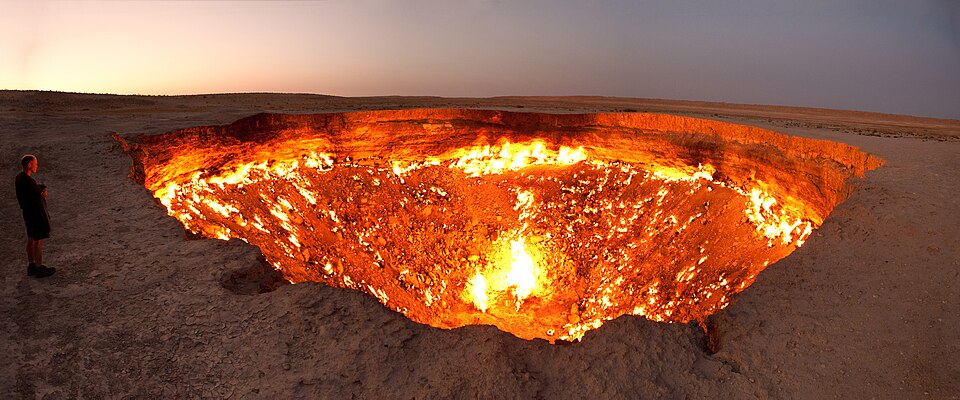
Correct — C, Turkmenistan. The Karakum — the name means 'black sand' in Turkic — is the great sand desert of Central Asia lying east of the Caspian Sea, and it covers roughly seventy per cent of Turkmenistan's territory, about 350,000 square kilometres. Two features make it easy to remember. The first is the Darvaza gas crater, the 'Door to Hell', a collapsed drilling site in the middle of the desert that has been burning since 1971. The second matters far more for the syllabus: the Karakum Canal, begun in 1954 and opened in 1958, runs about 1,375 kilometres across the desert and diverts something like 13 to 20 cubic kilometres of water a year out of the Amu Darya to irrigate southern Turkmenistan — one of the principal reasons the Aral Sea, which the Amu Darya used to feed, has shrunk to a fraction of its former size.
Why the others are wrong
- (a)Tajikistan — Tajikistan is a mountain state, not a desert one. The Pamirs cover the great bulk of it and the country is among the most mountainous in Asia; its geography question is glaciers and high valleys, not sand seas.
- (b)Kazakhstan — The best trap, because Kazakhstan does have desert. But its share of Central Asia's sand desert is the Kyzylkum — 'red sand' — which it holds jointly with Uzbekistan, along with the Betpak-Dala. The colour is the clue the question is playing on: Karakum is black sand and belongs to Turkmenistan, Kyzylkum is red sand and does not.
- (d)Kirgistan — Kyrgyzstan, spelt here in an older form, is dominated by the Tien Shan ranges and is the other high-mountain republic of Central Asia. Like Tajikistan it has no major sand desert.
Concept
Central Asia's five republics divide neatly into two geographic types, and almost every question about the region turns on that division. Turkmenistan, Uzbekistan and Kazakhstan are the lowland, arid states — sand desert, steppe and the two great rivers, the Amu Darya and the Syr Darya, that flow inland to the Aral Sea rather than to any ocean. Tajikistan and Kyrgyzstan are the highland states, built on the Pamir and Tien Shan, and are the source of that water rather than its consumers. The Karakum sits squarely in the first group, and the tension between upstream water and downstream irrigation is the region's defining resource problem.
Answer this by colour and by relief. 'Kara' is black and 'kum' is sand across the Turkic languages, so Karakum is the black-sand desert and Kyzylkum the red — pairing Karakum with Turkmenistan and Kyzylkum with Uzbekistan and Kazakhstan disposes of the only serious distractor. Relief handles the rest: Tajikistan and Kyrgyzstan are mountain republics and cannot host a major sand desert at all, so both can be struck without knowing anything about the Karakum itself. The wider payoff is the Aral Sea story, which UPSC has asked directly: Soviet-era diversion of the Amu Darya and Syr Darya for cotton irrigation, the Karakum Canal being the largest single diversion, drained the lake that both rivers fed.
Key facts
- The Karakum ('black sand') Desert lies in Turkmenistan and covers about seventy per cent of the country, roughly 350,000 sq km
- The Kyzylkum ('red sand') Desert lies mainly in Uzbekistan and Kazakhstan — the distractor this question is built on
- The Karakum Canal, begun 1954 and opened 1958, runs about 1,375 km and diverts water from the Amu Darya across the desert to southern Turkmenistan
- That diversion is among the principal causes of the desiccation of the Aral Sea, which the Amu Darya and the Syr Darya once fed
- The Darvaza gas crater, the 'Door to Hell', has burned in the middle of the Karakum since 1971
- Tajikistan (Pamirs) and Kyrgyzstan (Tien Shan) are the mountain republics of Central Asia and have no major sand desert
Study next
Common traps
- Swapping Karakum and Kyzylkum — black sand is Turkmenistan, red sand is Uzbekistan and Kazakhstan
- Assuming the largest Central Asian country must hold the region's famous desert; Kazakhstan's size is not the test
- Forgetting that Tajikistan and Kyrgyzstan are mountain states — they can be eliminated on relief alone
UPPSC asks world physical features as one-line 'which country' recall or as a four-way match of feature to country. UPSC prefers the consequence rather than the location — the Aral Sea's shrinkage, which countries border Afghanistan, why deserts form on the western margins of continents — so prepare the Karakum with its canal and its downstream effects, not just its address.
Related PYQs
Match List I with List II and select the correct answer using the code given below the lists : List I (Geographic feature) A. Great Victoria Desert B. Grand Canyon C. Lake Winnipeg D. Southern Alps List II (Country) 1. Australia 2. Canada 3. New Zealand 4. USA Code :
- (a) A-1 B-2 C-4 D-3
- (b) A-1 B-4 C-2 D-3
- (c) A-3 B-2 C-4 D-1
- (d) A-3 B-4 C-2 D-1
Answer(b) A-1 B-4 C-2 D-3
Identical in kind — a named physical feature placed in its country — and it opens with a desert. Practise this one for the habit of pinning world landforms to states rather than to vague regions.
Consider the following countries: 1. Azerbaijan 2. Kyrgyzstan 3. Tajikistan 4. Turkmenistan 5. Uzbekistan Which of the above have borders with Afghanistan?
- (a) 1, 2 and 5 only
- (b) 1, 2, 3 and 4 only
- (c) 3, 4 and 5 only
- (d) 1, 2, 3, 4 and 5
Answer(c) 3, 4 and 5 only
The same five republics, asked in the same year by UPSC. It rewards the political map of Central Asia rather than its physical one, and together the two questions cover most of what either commission asks about the region.
Match List - I with List - II and select the correct answer using the codes given below the lists : List - I (Country) A. Uzbekistan B. Tajikistan C. Kyrgyzstan D. Turkmenistan List - II (Capital) 1. Tashkent 2. Dushanbe 3. Bishkek 4. Ashgabat Codes :
- (a) A-1, B-2, C-3, D-4
- (b) A-1, B-2, C-4, D-3
- (c) A-1, B-3, C-4, D-2
- (d) A-1, B-4, C-2, D-3
Answer(a) A-1, B-2, C-3, D-4
The same four countries — three of which are the wrong options here — matched to their capitals. UPPSC clearly treats Central Asia as examinable ground, so learn the republics with their capitals, their relief and their deserts in one pass.
Practice
- practice — not a real PYQ
The Kyzylkum Desert of Central Asia lies mainly in which of the following countries?
- (a)Turkmenistan and Iran
- (b)Uzbekistan and Kazakhstan
- (c)Tajikistan and Kyrgyzstan
- (d)Afghanistan and Turkmenistan
Answer(b) Uzbekistan and Kazakhstan — the Kyzylkum or 'red sand' desert lies between the Amu Darya and the Syr Darya, mainly in Uzbekistan with a portion in Kazakhstan; the Karakum, or 'black sand', is the Turkmen desert. - practice — not a real PYQ
The Karakum Canal, one of the largest irrigation canals in the world, draws its water from which river?
- (a)Syr Darya
- (b)Ural
- (c)Amu Darya
- (d)Ili
Answer(c) Amu Darya — opened in 1958, the canal carries Amu Darya water some 1,375 km across the Karakum to southern Turkmenistan, and the diversion is a major cause of the Aral Sea's shrinkage.