
With reference to the 'Indian Ocean', which of the following statements is/are correct ? 1. It was called by the Ancient Greeks as Erythraean Sea. 2. It is spread on the either side of equator. Select the correct answer from the code given below : Code :
- (a)Only 2
- (b)Both 1 and 2
- (c)Neither 1 nor 2
- (d)Only 1
Correct — B, Both 1 and 2. Statement 1 is the standard historical point. Ancient Greek geographers knew these waters as the Erythraean Sea, Erythra Thalassa, the 'red sea' in the literal sense — and the name did not mean what 'Red Sea' means on a modern map. At its widest use, most famously in the first-century-CE Greek navigational handbook the Periplus of the Erythraean Sea, the term covered the present-day Red Sea, the Persian Gulf, the Arabian Sea and the Indian Ocean as a single sailing region, the whole world of the monsoon trade that carried Roman gold to Indian ports and pepper and cotton back. In narrower usage it meant the north-western Indian Ocean, the waters around Socotra between Cape Guardafui and the Hadhramaut coast. Either way, the Greeks' name for the Indian Ocean was the Erythraean Sea, and the statement stands. Statement 2 is straightforwardly true and is a matter of reading a globe. The Indian Ocean runs from roughly thirty degrees north, at the head of the Persian Gulf, down to sixty degrees south, where it meets the Southern Ocean, so the equator cuts across it and it lies in both hemispheres. Because Asia walls it in on the north, its northern reach is short and by far the greater part of its area lies south of the equator — the opposite of the impression a candidate carries from an atlas page centred on India. Both statements being correct, the answer is option (b).
- (a)Only 2 — It accepts the geography and rejects the history, and the history is sound. The Erythraean Sea is not an invented label: it is the name under which these waters enter Greek geographical writing, and it survives in the title of the Periplus of the Erythraean Sea, the first-century merchant's guide to the ports of the Red Sea, East Africa and western India. Candidates reject statement 1 because 'Erythraean' sounds like 'Red Sea' and they assume the Greeks meant only that narrow gulf; in Greek usage the term was far wider.
- (c)Neither 1 nor 2 — Both statements are in fact correct, so this option requires two independent errors. It is the choice of a candidate who doubts the Greek name and simultaneously thinks of the Indian Ocean as a northern-hemisphere sea because the Arabian Sea and the Bay of Bengal dominate the Indian map. Neither doubt survives contact with the facts: the Greek name is attested, and the ocean stretches from about thirty degrees north to the Antarctic waters at sixty degrees south.
- (d)Only 1 — This is the more interesting mistake, because it comes from a real but misapplied piece of knowledge. The Indian Ocean is the only ocean shut in by land on the north — Asia blocks it at roughly thirty degrees north — and a candidate who has learnt that fact sometimes converts it into 'the Indian Ocean does not extend far', or thinks of it as lying north of the equator around India. The truth is the reverse: the northern limit is short precisely because of the landmass, while the southern arm runs all the way to sixty degrees south, so most of the ocean is in the southern hemisphere and the equator passes through it. Statement 2 is correct.
The Indian Ocean is the third largest of the oceans, about 70.56 million square kilometres, roughly a fifth of the world's ocean surface. It is bounded by Asia to the north, Africa to the west, Australia to the east and the Southern Ocean to the south at sixty degrees south, and it is the only ocean named after a country. Its defining peculiarity is that northern wall of land: unlike the Atlantic and the Pacific, which run from Arctic to Antarctic, the Indian Ocean is cut off at about thirty degrees north, which is why it cannot develop a cold northern current system and why its northern circulation instead reverses twice a year with the monsoon winds. Its average depth is about 3,741 metres and its deepest known point lies in the Sunda or Java Trench, about 7,290 metres.
Statements about historical names are easier to test than they look, because the name almost always survives in a document you have heard of. Here it survives in the Periplus of the Erythraean Sea, and if you can place that text — a first-century Greek guide to the monsoon trade with India — you have verified statement 1 without any further recall. Statement 2 is a globe question, and the safe way to answer it is to name the two limits rather than to trust a mental image: about thirty degrees north at the head of the Persian Gulf, sixty degrees south at the Southern Ocean. Two limits on opposite sides of zero means the equator runs through the ocean. One honest refinement worth carrying into an interview or a mains answer: the Greek term was elastic. In its widest use it took in the Red Sea, the Persian Gulf, the Arabian Sea and the Indian Ocean together; in its narrower use it meant the north-western Indian Ocean around Socotra. UPPSC is testing the broad, textbook sense, and in that sense the statement is correct.
- The ancient Greeks called these waters the Erythraean Sea (Erythra Thalassa); the first-century-CE Periplus of the Erythraean Sea used the name for the Red Sea, Persian Gulf, Arabian Sea and Indian Ocean together, as one region of monsoon navigation
- The Indian Ocean extends from about 30 degrees north, at the head of the Persian Gulf, to 60 degrees south at the boundary with the Southern Ocean — so the equator crosses it and most of its area lies in the southern hemisphere
- It is the third-largest ocean at about 70.56 million square kilometres, roughly 20 per cent of the world's ocean surface, bounded by Asia to the north, Africa to the west and Australia to the east
- It is the only ocean named after a country, and the only one closed off by a landmass on the north — which is why its northern currents reverse with the monsoon instead of forming a standing gyre
- Average depth about 3,741 metres; the deepest point is in the Sunda (Java) Trench at about 7,290 metres, off Indonesia
- Other historical names attach to the same waters — traditional South Asian geography knew it as the Mahodadhi, and fifteenth-century Chinese voyagers as the Western Oceans
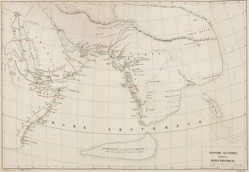
- Reading 'Erythraean' as meaning only the Red Sea. The Greek term was elastic and at its widest covered the whole Indian Ocean; the Periplus of the Erythraean Sea is the proof, since it describes voyages to East Africa and to India
- Picturing the Indian Ocean as a northern-hemisphere sea because India, the Arabian Sea and the Bay of Bengal fill the Indian atlas page. Its northern limit is only about 30 degrees north, while its southern arm runs to 60 degrees south
- Mixing up the ocean's two famous 'onlys'. It is the only ocean named after a country and the only one blocked by land on the north — neither of which prevents it from straddling the equator
UPPSC likes two-statement items in which one statement is a historical or naming fact and the other a plain locational fact, so that the candidate must clear both a history and a geography hurdle to score. Its Indian Ocean questions otherwise run to currents, islands and straits. UPSC prefers the process side of the same ocean — why the northern currents reverse, what the Indian Ocean Dipole does to the monsoon, which trench lies where — and it tests the ancient trade world through the Periplus and the port sites rather than through the name.
Which one of the following factors is responsible for the change in the regular direction of the ocean currents in the Indian Ocean?
- (a) Indian Ocean is ‘half an ocean’
- (b) Indian Ocean has monsoon drift
- (c) Indian Ocean is a land-locked ocean
- (d) Indian Ocean has greater variation in salinity
Answer(b) Indian Ocean has monsoon drift
Works over the same peculiarity from the other end. Its rejected options — 'half an ocean' and 'land-locked ocean' — are describing the very feature that shapes the answer to statement 2 here: Asia shuts the ocean off at about thirty degrees north, so it has no northern half to speak of and the greater part of it lies south of the equator. The reversal of its northern currents is the consequence of that truncated shape meeting the monsoon.
In which one of the following oceans is Diamantina Trench situated?
- (a) Pacific Ocean
- (b) Atlantic Ocean
- (c) Indian Ocean
- (d) Arctic Ocean
Answer(c) Indian Ocean
A quiet demonstration of statement 2. The Diamantina Trench lies in the south-eastern Indian Ocean, south-west of Australia and far into the southern hemisphere — while the Persian Gulf marks the ocean's other end at about thirty degrees north. Any candidate who can place both features on a map has already answered whether the Indian Ocean spreads on either side of the equator.
Which of the following ocean currents is associated with Indian Ocean ?
- (a) Florida current
- (b) Canary current
- (c) Agulhas current
- (d) Kurile current
Answer(c) Agulhas current
The same commission testing the extent of the same ocean, in disguise. The Agulhas is a warm current running down the east coast of southern Africa, entirely in the southern hemisphere, and it belongs to the Indian Ocean — which is only possible because the ocean reaches far south of the equator. Knowing where its currents run is knowing where the ocean is.
With reference to Socotra Island, which of the following statement/s is/are correct ? 1. It is an Island of Oman, situated in the Arabian Sea. 2. It was designated as a world natural heritage site by UNESCO in 2008. Select the correct answer using the codes given below. Codes :
- (a) Only 1
- (b) Only 2
- (c) Both 1 and 2
- (d) Neither 1 nor 2
Answer(b) Only 2
Lands on the exact patch of sea the Greeks meant. Socotra — which belongs to Yemen, not to Oman as that question's first statement wrongly says — sits at the mouth of the Gulf of Aden, and in the narrower Greek usage the Erythraean Sea meant precisely these waters around it. It is also built like the present question, two statements and a four-way code, so it drills the same habit of testing each statement separately before reading the options.
- practice — not a real PYQ
The 'Periplus of the Erythraean Sea', a first-century CE Greek text, is best described as
- (a)a Roman legal code regulating trade with the East
- (b)a merchant's guide to the ports, goods and sailing routes of the Red Sea, East Africa and India
- (c)a Greek epic poem on the voyages of Alexander's fleet
- (d)a Byzantine treatise on shipbuilding
Answer(b) a merchant's guide to the ports, goods and sailing routes of the Red Sea, East Africa and India — and its title preserves the ancient Greek name for the Indian Ocean.
- practice — not a real PYQ
Which one of the following is a distinguishing feature of the Indian Ocean?
- (a)It is the only ocean that lies wholly within the southern hemisphere
- (b)It is the only ocean bounded on the north by a landmass
- (c)It is the only ocean without any deep-sea trench
- (d)It is the only ocean whose surface currents never change direction
Answer(b) It is the only ocean bounded on the north by a landmass — Asia closes it at about 30°N, which is also why its northern currents reverse with the monsoon rather than forming a fixed gyre.