
Which one of the following pairs (Deccan Trap – Peculiarity) is not correctly matched ?
- (a)Depth of middle trap – 1200 metres approximately
- (b)Intertrappean beds – Fossils of sea plants and animals
- (c)Depth of lower trap – 150 metres approximately
- (d)Depth of upper trap – 450 metres approximately
Correct — B, Intertrappean beds – Fossils of sea plants and animals. The intertrappean beds are the thin sedimentary layers sandwiched between successive basalt flows of the Deccan Trap. They formed in the quiet intervals between eruptions, when a lava sheet cooled, weathered and ponded water, so that shallow lakes, ponds and streams spread across the plateau surface and laid down silt, clay and limestone before the next flow buried them. Everything that lived in those pools was therefore a land-and-freshwater community, and that is exactly what the beds preserve: freshwater molluscs and gastropods, charophyte algae, ostracods, fish, and the remains of early frogs such as Indobatrachus, along with plant material. They are not marine deposits and they do not carry fossils of sea plants and animals — the sea never covered the erupting lava plateau. The same is true of the infratrappean beds below the lavas, the Lameta Formation, whose freshwater and fluvial sediments are famous instead for dinosaur remains. So the peculiarity attached to the intertrappean beds in option (b) is the one that is false, and (b) is the marked answer. A note on honesty about the other three options. The metre figures for the lower, middle and upper traps are the numbers carried by the classical three-fold division of the Deccan Trap used in Indian geology and geography textbooks, and the commission has drawn the question from that source; the examiner treats them as correct. Published estimates of Deccan thickness vary a great deal from place to place — the whole pile exceeds two kilometres near the west coast and thins eastwards — so we reproduce the textbook figures as the examiner's, rather than vouching for the precise metres. Nothing turns on them here: the deliberate falsifier the setter planted is the word 'sea'.
- (a)Depth of middle trap – 1200 metres approximately — Treated as correctly matched, so it cannot be the answer. The Deccan Trap is divided stratigraphically into Lower, Middle and Upper traps, and about 1,200 metres is the thickness the standard Indian textbook account gives the middle division — the thickest of the three. It is worth knowing that thickness measurements vary widely across the province, the full lava pile being more than two kilometres thick near the western margin and thinning towards the east, so treat these as the classification's conventional figures rather than a single measured number.
- (c)Depth of lower trap – 150 metres approximately — Treated as correctly matched. About 150 metres is the figure the same three-fold division attaches to the lower traps, the thinnest of the three divisions and the earliest to be erupted. Note that the traps are not measured like a single sheet: each division is a stack of many individual flows, and it is the flows piled one on another that give the formation its stepped or staircase profile.
- (d)Depth of upper trap – 450 metres approximately — Treated as correctly matched. About 450 metres is the conventional figure for the upper traps, the youngest of the three divisions.
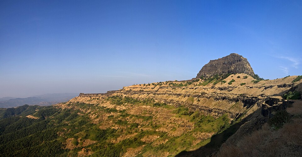
The Deccan Traps are one of the world's great flood-basalt provinces. Enormous volumes of runny basaltic lava poured out of long fissures, not from a single cone, and spread as near-horizontal sheets one on top of another. The eruptions occurred over a period of roughly 600,000 to 800,000 years, about 66.3 to 65.6 million years ago, straddling the Cretaceous–Palaeogene boundary and so overlapping the extinction of the dinosaurs. The lavas cover about 500,000 square kilometres of western and central India today and originally may have covered around 1.5 million square kilometres; the pile is more than two kilometres thick near the west coast. The name comes from the Scandinavian word for a stair or step, because differential weathering of the stacked flows carves the characteristic terraced hillsides seen across Maharashtra and the northern Western Ghats. Weathering of this basalt in situ produces the regur or black cotton soil that made the Deccan India's cotton belt.
This question tests one thing that actually matters and three that are memory ballast. The thing that matters is what an intertrappean bed is. Between two eruptions there is a pause — sometimes long enough to weather the lava surface and let lakes and streams develop on it — and the sediment laid down in that pause becomes a thin bed trapped between the flows. Ask yourself where a plant or animal in that bed must have lived, and the answer is obvious: on land, or in fresh water, on top of a lava plateau. Marine fossils require the sea, and the Deccan lavas were erupted on a continental landmass. That reasoning gets you to (b) without memorising anything. Keep the vocabulary straight while you are here: infratrappean beds lie BELOW the lava pile (the Lameta Formation, freshwater and fluvial, with famous dinosaur remains), intertrappean beds lie BETWEEN flows, and both are non-marine. If you want the contrast, India's genuinely marine fossil sequences are elsewhere — in the Tethyan sediments folded into the Himalaya, whose marine fossils are the evidence that an ocean once lay where the mountains now stand.
- The Deccan Traps are fissure-erupted flood basalts laid down roughly 66.3 to 65.6 million years ago, spanning the Cretaceous–Palaeogene boundary; they cover about 500,000 square kilometres today and the pile is over two kilometres thick near the west coast.
- Intertrappean beds are sedimentary layers deposited between successive lava flows. They and the infratrappean (Lameta Formation) beds contain freshwater molluscs, charophytes, ostracods, fish, plant remains and early frogs such as Indobatrachus — freshwater and terrestrial life, not marine.
- The Deccan Traps are divided stratigraphically into Lower, Middle and Upper traps; the metre figures used in options (a), (c) and (d) come from the classical textbook version of that three-fold division and thickness estimates vary widely across the province.
- 'Trap' derives from a Scandinavian word for stair or step, after the terraced hillsides produced when stacked horizontal lava flows weather unevenly.
- In-situ weathering of Deccan basalt produces regur or black cotton soil — the moisture-retentive clay soil of Maharashtra, Gujarat and Madhya Pradesh on which India's cotton belt sits.
- Confusing infratrappean with intertrappean beds. Infratrappean beds (the Lameta Formation) lie below the lavas; intertrappean beds lie between two flows. Both are freshwater and terrestrial, never marine.
- Assuming any fossil-bearing sedimentary bed means a former sea. The depositional environment decides it — lava-plateau ponds and lakes give freshwater fossils, while marine fossils in India point to the Tethyan sediments of the Himalaya or to coastal sequences.
- Treating the textbook depth figures for the lower, middle and upper traps as precise measurements. They are the conventional numbers of the classical three-fold division; real thickness varies enormously across the province.
UPPSC asks Indian geology as 'which pair is not correctly matched' with one planted falsifier among plausible numbers — so look for the qualitative odd-one-out rather than trying to verify the figures. UPSC prefers to ask the age or the origin: which rock system holds India's coal, what parent rock gives black soil, how the Deccan relates to the Cretaceous–Palaeogene boundary.
Match List I with List II and select the correct answer using the codes given below the lists: List I I. Deccan Traps II. Western Ghats III. Aravalli IV. Narmada-Tapi List II A) Late Cenozoic B) Pre-Cambrian C) Cretaceous-Eocene D) Cambrian Alluvial deposits E) Pleistocene Codes:
- (a) I-C, II-E, III-A, IV-D
- (b) I-C, II-A, III-B, IV-E
- (c) I-B, II-A, III-C, IV-D
- (d) I-A, II-D, III-B, IV-E
Answer(b) I-C, II-A, III-B, IV-E
The same formation, asked for its age — the Deccan Traps are Cretaceous–Eocene, which is the other half of the fact used here: lavas erupted around the Cretaceous–Palaeogene boundary onto a continental surface, so the sediments trapped between the flows are freshwater, not marine.
The black cotton soil of India has been formed due to the weathering of
- (a) brown forest soil
- (b) fissure volcanic rock
- (c) granite and achist
- (d) shale and limestone
Answer(b) fissure volcanic rock
Follows the Deccan Trap forward in time — the same fissure-erupted basalt whose flows enclose the intertrappean beds is the parent rock that weathers into regur or black cotton soil, which is how UPSC most often examines this province.
With reference to the Himalayan range, which of the statements is/are correct ? 1. The sedimentary rocks of the greater Himalayas were fossil less. 2. Marine livings fossils are found in the sedimentary rocks of lesser Himalayas. 3. Remains of human civilization are found in outer or Shivalik Himalayas. Select the correct answer using the codes given below : Codes :
- (a) 1 and 2 only
- (b) 2 and 3 only
- (c) 1 and 3 only
- (d) 1, 2 and 3 are correct
Answer(d) 1, 2 and 3 are correct
The mirror image of this question — UPPSC there asks which Indian formations carry marine fossils and locates them in the Lesser Himalaya's sedimentary belt, laid down under the Tethys. That is precisely where marine fossils belong, and precisely why claiming them for the freshwater intertrappean beds of the Deccan is the planted error here.
Which of the following statements is correct about laterite soil? (1) This soil is developed in areas with high temperature and heavy rainfall. (2) It is poor in iron oxide and aluminium. Select the correct answer using the code given below – Code -
- (a) Only 2
- (b) Neither 1 nor 2
- (c) Both 1 and 2
- (d) Only 1
Answer(d) Only 1
Sits in the same corner of the syllabus — parent rock and climate deciding what a formation yields. Laterite is what the same Deccan basalt becomes under heavy rainfall on the high summits of the Western Ghats, while in the drier interior it weathers to regur, the black cotton soil.
- practice — not a real PYQ
The intertrappean beds of the Deccan Trap region are best described as
- (a)marine sediments deposited when the sea transgressed over the lava plateau
- (b)sedimentary layers laid down in freshwater lakes and streams during pauses between successive lava flows
- (c)windblown loess deposits accumulated after the eruptions ceased
- (d)glacial tillite beds of Gondwana age underlying the lavas
Answer(b) sedimentary layers laid down in freshwater lakes and streams during pauses between successive lava flows — they preserve freshwater molluscs, charophytes, ostracods, fish, plants and early frogs, all non-marine. Gondwana tillites are far older and belong to a different rock system entirely.
- practice — not a real PYQ
The eruption of the Deccan Traps is dated to approximately which geological boundary?
- (a)The Permian–Triassic boundary
- (b)The Cretaceous–Palaeogene boundary
- (c)The Pliocene–Pleistocene boundary
- (d)The Precambrian–Cambrian boundary
Answer(b) The Cretaceous–Palaeogene boundary — the Deccan lavas were erupted around 66 million years ago, spanning the boundary that also marks the extinction of the dinosaurs, which is why Deccan volcanism features in the debate about that extinction alongside the Chicxulub impact.