
Match List-I with List-II and choose the correct answer using the codes given below the lists : List-I A. Planting Hearth B. Cryophyte Steppe C. World Floral Regions D. Puszta Grassland List-II 1. Hungary 2. Adolf Engler 3. C.O. Sauer 4. Arctic Tundra Codes :
- (a)A-4, B-3, C-2, D-1
- (b)A-3, B-4, C-2, D-1
- (c)A-3, B-4, C-1, D-2
- (d)A-1, B-2, C-3, D-4
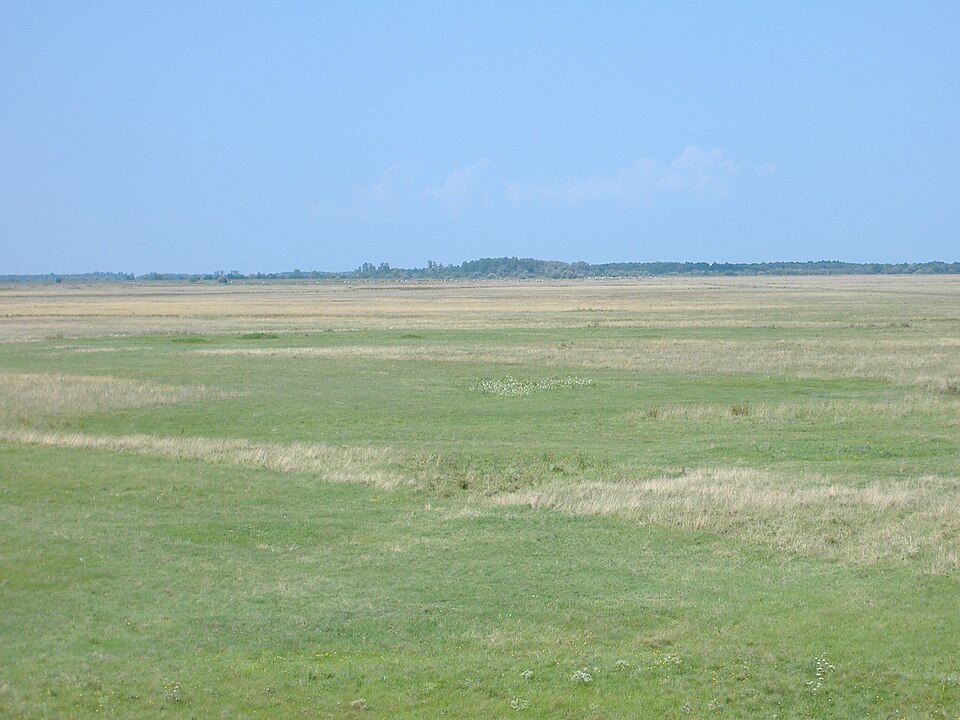
Correct — B, A-3, B-4, C-2, D-1. Start with the pair you can be certain of. D–1: the Puszta is the Hungarian name for the great treeless grassland plain of the Alföld, the Great Hungarian Plain in eastern Hungary. Its classic tract, the Hortobágy, is Hungary's first and largest national park (1973), the largest semi-natural grassland in Europe, and a UNESCO World Heritage Site since 1999 — inscribed as a cultural landscape for its four-thousand-year record of pastoralism, its Grey cattle and racka sheep and its mounted csikós herdsmen. Every list of the regional names of the world's temperate grasslands — prairie, pampas, steppe, veld, downs, puszta — puts the puszta in Hungary. Fixing D–1 immediately kills options (c) and (d), which send the puszta to Adolf Engler and to the Arctic tundra respectively. C–2: Adolf Engler (1844–1930), the German botanist and director of the Berlin botanical garden, was the first to draw a world map of the limits of distribution of floras, dividing the earth into four major floral regions or realms; his Syllabus der Pflanzenfamilien (first published 1892, many later editions) set out that division. Later schemes — Ronald Good's six floristic kingdoms (1947) and Armen Takhtajan's thirty-five floristic regions (1978, 1986) — are built on his foundation. B–4: a cryophyte, from the Greek kryos (icy cold) and phyton (plant), is a plant adapted to cold, snow-bound conditions, so a 'cryophyte steppe' is the cold, treeless, low grass-sedge-and-lichen formation of the high latitudes — the Arctic tundra, whose mosses, lichens, sedges and dwarf shrubs over permafrost are the textbook cryophytic community. A–3: the planting hearth belongs with Carl Ortwin Sauer (1889–1975), professor of geography at Berkeley from 1923 to 1957 and the founder of the Berkeley school of cultural geography, whose Agricultural Origins and Dispersals (1952) is the work behind the idea that farming did not begin everywhere at once but in a small number of 'hearths' from which it spread — the title itself names both the origins and the dispersals. Indian geography syllabi attach the 'planting hearth' — the hearth of vegetative planting, where crops are propagated from tubers, roots and cuttings rather than from seed — to Sauer's scheme. That gives A-3, B-4, C-2, D-1, which is option (b).
- (a)A-4, B-3, C-2, D-1 — This is the near-miss: it gets C and D right but swaps A and B, making the planting hearth a feature of the Arctic tundra and crediting the cryophyte steppe to C.O. Sauer. Neither survives a second's thought — no hearth of early agriculture lay in the Arctic, which is treeless, frozen for most of the year and beyond the limit of cultivation, and Sauer's name attaches to agricultural origins, not to cold-zone vegetation types.
- (c)A-3, B-4, C-1, D-2 — It gets A and B right but swaps C and D, sending the world floral regions to Hungary and the Puszta grassland to Adolf Engler. A country cannot be the author of a world classification scheme, and the puszta is a place-name for a grassland, not a botanist.
- (d)A-1, B-2, C-3, D-4 — The straight 1-2-3-4 sequence, which matches nothing: it puts the planting hearth in Hungary, credits the cryophyte steppe to Adolf Engler, hands the world floral regions to C.O. Sauer and equates the Puszta grassland with the Arctic tundra. Testing any single pair against it is enough to eliminate it.
This item is a compressed tour of biogeography: two entries are vegetation formations known by regional names (the puszta of Hungary, the cryophyte steppe of the Arctic), and two are ideas known by the names of the scholars who framed them (Adolf Engler's division of the world into floral regions, and C.O. Sauer's hearths of agricultural origin). The world's temperate grasslands are one biome under many local names — prairie in North America, pampas in Argentina and Uruguay, steppe across Eurasia, veld in South Africa, downs in Australia, canterbury in New Zealand and puszta in Hungary — while phytogeography, the study of how plants are distributed over the earth, divides the world instead into floral kingdoms and regions defined by the plant families endemic to them.
The efficient way through a four-pair match list is to find the one pair you are sure of and use it to delete codes, rather than trying to solve all four. Here D–1 is that pair: the puszta is as firmly Hungarian as the pampas is Argentine, and it removes two of the four options at a stroke. The remaining choice, between (a) and (b), is a single swap — does the planting hearth go to Sauer or to the Arctic tundra? The word 'hearth' looks like a place, which is the bait; but in List-II the only entries that could own a concept are the two personal names, and of the two it is Sauer, a geographer of agricultural origins, not Engler, a botanist of plant distribution, whose work the phrase comes from.
- Regional names of the world's temperate grasslands: Prairie (North America), Pampas (Argentina and Uruguay), Steppe (Eurasia), Veld (South Africa), Downs (Australia), Canterbury (New Zealand), Puszta (Hungary).
- The Puszta is the grassland plain of the Alföld or Great Hungarian Plain; the Hortobágy is its classic tract — an 800 sq km national park declared in 1973, Hungary's largest protected area, the largest semi-natural grassland in Europe, and a UNESCO World Heritage Site (1999) inscribed as a cultural landscape for its pastoral tradition.
- Adolf Engler (1844–1930) was the first to map the world's floras, dividing the earth into four major floral regions; Ronald Good (1947) refined this into six floristic kingdoms and Armen Takhtajan (1978, 1986) into thirty-five floristic regions.
- Carl Ortwin Sauer (1889–1975) was professor of geography at Berkeley from 1923 to 1957 and the author of Agricultural Origins and Dispersals (1952), the work behind the idea that agriculture began in a limited number of hearths and spread outward from them.
- Cryophytes are cold-adapted plants; the Arctic tundra's mosses, lichens, sedges and dwarf shrubs, growing over permafrost through a very short summer, are the classic cryophytic vegetation.
- Choosing the straight 1-2-3-4 code (option d) under time pressure. Test it against even one pair and it collapses.
- Reading 'hearth' as a place and hunting for a region in List-II. In this list the partner for a concept has to be the scholar who framed it.
- Mixing up the plant-adaptation prefixes: cryophyte (cold), xerophyte (drought), halophyte (salt), hydrophyte (water), mesophyte (moderate). Only the first fits a tundra 'steppe'.
- Confusing Adolf Engler, a botanist who mapped plant distribution, with C.O. Sauer, a geographer of agricultural origins — the question is designed so that swapping them still looks plausible.
UPPSC leans much harder than UPSC on scholar-and-concept matching in geography — Sauer, Engler, Ratzel, Humboldt, Koppen, Thornthwaite, Vavilov — and on the regional names of grasslands and natural regions. UPSC prefers to describe a region in prose ('climate is extreme, rainfall is scanty, the people used to be nomadic herders') and ask you to name it, or to test the domestication angle through crops and the Columbian Exchange.
“Climate is extreme, rainfall is scanty and the people used to be nomadic herders.” The above statement best describes which of the following regions?
- (a) African Savannah
- (b) Central Asian Steppe
- (c) North American Prairie
- (d) Siberian Tundra
Answer(b) Central Asian Steppe
The same material — telling the world's temperate grasslands apart by their regional names and their climate — asked in UPSC's descriptive style instead of as a match list. The steppe is the Eurasian sibling of the Hungarian puszta.
Which one of the following groups of plants was domesticated in the ‘New World’ and introduced into the ‘Old World’?
- (a) Tobacco, cocoa and rubber
- (b) Tobacco, cotton and rubber
- (c) Cotton, coffee and sugarcane
- (d) Rubber, coffee and wheat
Answer(a) Tobacco, cocoa and rubber
The applied form of the hearth idea that item A points to: crops were domesticated in a few source regions and dispersed from them, which is exactly the origins-and-dispersals framework C.O. Sauer's work is known for.
Which one of the following natural regions is known as 'Land of Big Games' ?
- (a) Temperate Grassland
- (b) Tropical Monsoon Region
- (c) Hot Desert Region
- (d) Tropical Savanna Region
Answer(d) Tropical Savanna Region
UPPSC's other question from the same block of world natural regions, with temperate grassland — the puszta's type — set as the trap option. Both items reward knowing what each grassland belt is actually named and known for.
- practice — not a real PYQ
Which one of the following pairs (Temperate grassland – Region) is NOT correctly matched?
- (a)Prairie – North America
- (b)Veld – South Africa
- (c)Pampas – Argentina
- (d)Downs – Hungary
Answer(d) Downs – Hungary — the Downs are the temperate grasslands of Australia; Hungary's grassland is the Puszta of the Great Hungarian Plain.
- practice — not a real PYQ
The first attempt to divide the world into floral regions on a world map was made by:
- (a)Ronald Good
- (b)Armen Takhtajan
- (c)Adolf Engler
- (d)Carl O. Sauer
Answer(c) Adolf Engler — the German botanist mapped the limits of distribution of the world's floras in the late nineteenth century, dividing the earth into four major floral realms; Good and Takhtajan later refined the scheme, while Sauer worked on agricultural origins, not plant geography.