
Which one of the following pairs is not correctly matched regarding peculiarities of Ramganga project ?
- (a)Dam’s length – 825·8 metres
- (b)Hydropower generation capacity – 198 MW
- (c)Location – Garhwal (Uttarakhand)
- (d)Irrigated area – 6 lac hectares
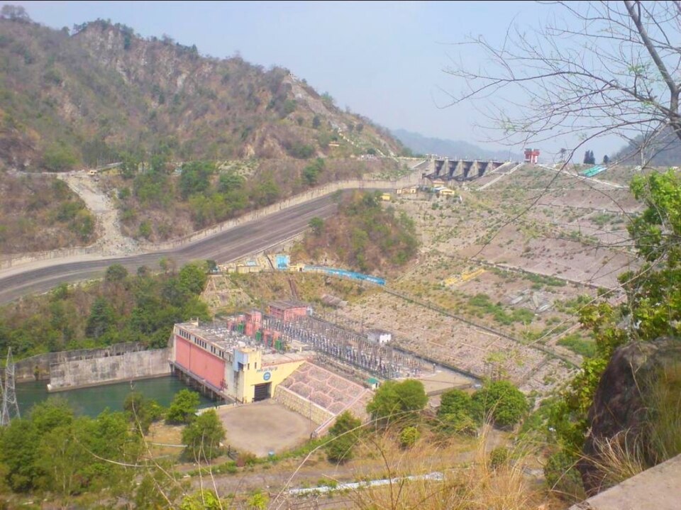
Correct — A, Dam's length – 825·8 metres. This is the one figure in the set that the dam's own specification does not support. The Ramganga Dam, better known as the Kalagarh Dam, is an earth-and-rockfill embankment built across the Ramganga river about three kilometres upstream of Kalagarh in Pauri Garhwal district of Uttarakhand. Its standard specification is 128 metres high and about 630 metres long — a tall dam on a comparatively narrow Himalayan foothill gorge, which is exactly why it does not need an 800-metre-plus crest. The 825·8-metre figure is the examiner's falsifier: it is neither the crest length nor the height nor any other published dimension of this structure. Construction ran from 1961 to 1974 and the three generating units came on line between December 1975 and March 1977. Everything else in the question checks out, so (a) is the pair that is not correctly matched. One warning about how to attack an item like this: do not go hunting for a wrong figure among the numbers you find hardest to recall. Here the two 'difficult' numbers — 198 MW and 6 lakh hectares — are both defensible, and the one that breaks is the physically simplest.
- (b)Hydropower generation capacity – 198 MW — Correctly matched, so it cannot be the answer. The Ramganga power station is rated at 198 MW, made up of three Francis turbines of 66 MW each. It is a modest installation by national standards — a fraction of the 1,000 MW at Tehri — because the project's first purpose was irrigation and flood moderation for the western Uttar Pradesh plain, with power as a by-product of releases already being made for the canals.
- (c)Location – Garhwal (Uttarakhand) — Correctly matched. The dam stands at Kalagarh in Pauri Garhwal district, which since 9 November 2000 has been part of Uttarakhand; before that the whole project lay inside undivided Uttar Pradesh, which is why older textbooks still file the Ramganga project under UP. The reservoir spreads north-east of the dam into the Kalagarh side of the Corbett Tiger Reserve. Both the 'Garhwal' and the 'Uttarakhand' halves of this pair are therefore accurate — a candidate who marks this option is usually being misled by the older UP attribution.
- (d)Irrigated area – 6 lac hectares — Correctly matched as the question intends it, and this is the option most candidates wrongly attack. Two different numbers circulate for this project and both are real. The dam's own irrigation entitlement — the area served directly from the reservoir — is about 57,500 hectares. The Ramganga PROJECT, however, is a canal system of more than 6,300 kilometres with three barrages downstream, and Indian irrigation-department and geography sources put its command area at roughly six lakh hectares across western Uttar Pradesh. The question says 'Ramganga project', not 'Ramganga dam', so the six-lakh-hectare figure is the project command and is not the falsifier.
The Ramganga project is a multipurpose river-valley scheme of the 1960s and 1970s built on the Ramganga (West), a Himalayan tributary that rises in the Kumaon hills, cuts through the Shivaliks past Kalagarh and then joins the Ganga in the plains near Kannauj. A multipurpose project by definition serves several ends at once — here irrigation for western Uttar Pradesh, flood moderation for the Ramganga's notoriously flashy foothill flow, hydro-power, and a large reservoir that later became an ecological asset inside the Corbett landscape. The dam is an embankment structure, meaning it is built up from compacted earth and rock rather than cast in concrete, which is the usual choice on wide, alluvium-floored Himalayan foothill sites.
UPPSC repeatedly asks single-project specification questions in the 'which pair is NOT correctly matched' form, and the reliable way to crack them is to sort the four numbers by how physically constrained they are. Height and length are fixed by the valley and are the easiest to check against a remembered figure; installed capacity and command area drift between sources and are the ones an examiner rarely uses as the falsifier, precisely because they are contestable. Here the height-to-length ratio is the giveaway: a 128-metre-high dam pinched into a foothill gorge is a tall, short structure of roughly 630 metres, and quoting 825·8 metres would make it an unusually long dam for its site. The second habit worth building is to read the noun in the stem — 'Ramganga PROJECT' legitimately includes the barrages and the six-thousand-kilometre canal network, so the six-lakh-hectare command area belongs to the project even though the dam alone irrigates far less.
- Ramganga Dam (Kalagarh Dam) — an earth-and-rockfill embankment dam on the Ramganga river about 3 km upstream of Kalagarh, Pauri Garhwal district, Uttarakhand. Height 128 m; length about 630 m, not 825·8 m.
- Construction ran 1961–1974; the three power units entered service between December 1975 and March 1977. Installed capacity 198 MW from 3 × 66 MW Francis turbines.
- Reservoir: total capacity about 245 million cubic metres, surface area roughly 78 sq km, catchment about 3,134 sq km. A 72-m saddle dam on the Chui Sot supplements the main structure.
- Irrigation: about 57,500 hectares served directly from the dam, but the wider Ramganga project — over 6,300 km of canals and three barrages — commands of the order of six lakh hectares in western Uttar Pradesh.
- The Ramganga (West) is a Himalayan tributary of the Ganga; it rises in Uttarakhand and joins the Ganga in the plains near Kannauj (the confluence lies at Katri Chandapur in Hardoi district, on the opposite bank).
- Confusing the Ramganga (West), the Himalayan tributary that joins the Ganga near Kannauj, with the Ramganga (East), a separate stream in Kumaon that joins the Sarju.
- Assuming a dam's irrigated area and a project's command area are the same number. The Ramganga dam serves about 57,500 ha directly while the project commands roughly six lakh hectares — both figures are published and neither is a mistake.
- Filing the Ramganga project under Uttar Pradesh only. The dam site moved into Uttarakhand when the state was created on 9 November 2000, even though the beneficiary command area is still in western UP.
UPPSC likes single-project specification items in the 'not correctly matched' format, usually with one falsified number among three sound ones; UPSC prefers to ask which river a named project stands on, or to pair projects with states in a match-list.
Which of the following pairs are correctly matched? I. Idukki — Thermal power station II. Sabarigiri — Hydro-electric project III. Ghatprabha — Irrigation project IV. Ramganga — Multipurpose project Select the correct answer by using the codes given below:
- (a) II, III and IV
- (b) I, II, III and IV
- (c) III and IV
- (d) I and II
Answer(a) II, III and IV
The same project in the same 'correctly matched' format — UPSC's pair 'Ramganga — Multipurpose project' is the classification that makes UPPSC's question legitimate, because irrigation, power and flood control all belong to one scheme.
Which of the following statement is correct? (1) Ram Ganga river joins the Ganga at Kannauj. (2) River Betwa joins the Yamuna near Prayagraj. Select the correct answer using the code given below –
- (a) Only 2
- (b) Both 1 and 2
- (c) Neither 1 nor 2
- (d) Only 1
Answer(d) Only 1
UPPSC asked the river itself the previous year — where the Ramganga meets the Ganga. Put the two together and you have the whole system: dammed at Kalagarh in Pauri Garhwal, commanded through canals across western UP, and merging with the Ganga near Kannauj.
- practice — not a real PYQ
The Ramganga (Kalagarh) Dam is built across the Ramganga river in which district?
- (a)Bijnor, Uttar Pradesh
- (b)Pauri Garhwal, Uttarakhand
- (c)Nainital, Uttarakhand
- (d)Moradabad, Uttar Pradesh
Answer(b) Pauri Garhwal, Uttarakhand — the dam stands about 3 km upstream of Kalagarh in Pauri Garhwal district. The command area it serves lies downstream in western Uttar Pradesh, which is why the project is often mis-filed under UP.
- practice — not a real PYQ
Which one of the following is an embankment (earth-and-rockfill) dam rather than a concrete gravity dam?
- (a)Bhakra Dam
- (b)Hirakud Dam
- (c)Ramganga (Kalagarh) Dam
- (d)Nagarjuna Sagar Dam
Answer(c) Ramganga (Kalagarh) Dam — it is an earth-and-rockfill embankment structure 128 m high, unlike Bhakra and Nagarjuna Sagar, which are concrete gravity dams; Hirakud is a composite structure with long earthen flanks but is classed by its concrete gravity section.