
Which of the following soils is found in the Chambal basin?
- (a)Red and yellow soil
- (b)Laterite soil
- (c)Alluvial soil
- (d)Red loamy soil
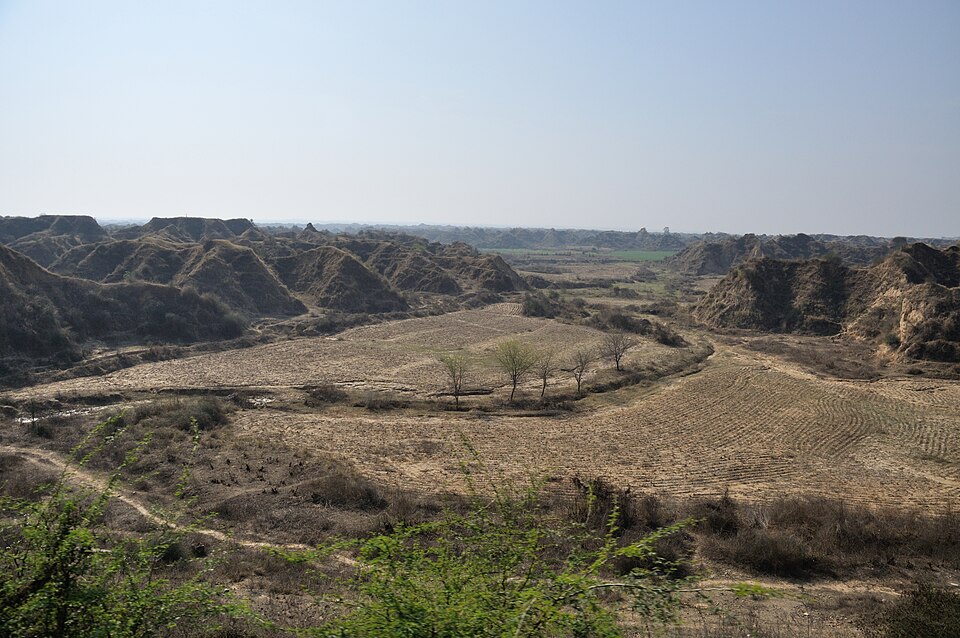
Correct — C, alluvial soil. The Chambal rises in the Vindhyas near Mhow, flows north and north-east across the northern edge of Madhya Pradesh and joins the Yamuna, and its lower basin — Sheopur, Morena, Bhind and the Gwalior tract — is the southern fringe of the Ganga–Yamuna plain, floored by sediment the river itself has deposited. In the standard soil map of Madhya Pradesh, alluvial soil is precisely the soil of the north-western part of the state, in contrast to the black soil of Malwa, the Narmada valley and Nimar, and the red-and-yellow soils of Baghelkhand in the east. The region's signature landform confirms it: the Chambal ravines (behad) are badland gully erosion, and gullies on that scale can only be cut into deep, soft, unconsolidated alluvium.
- (a)Red and yellow soil — This is the soil of eastern Madhya Pradesh — the Baghelkhand plateau and the Rewa–Panna–Shahdol belt — formed in place on old crystalline and metamorphic rock. It is on the opposite side of the state from the Chambal.
- (b)Laterite soil — Laterite needs heavy seasonal rainfall that leaches away silica and leaves iron and aluminium oxides behind, which is why it belongs to the Western Ghats, the north-east and the wetter plateau tops. The semi-arid Chambal tract has neither that rainfall nor that leaching, and laterite occurs in Madhya Pradesh only in small high-plateau patches.
- (d)Red loamy soil — Another residual soil, weathered in situ from crystalline rock on the eastern and southern plateaus. The material in the Chambal basin was transported and laid down by the river, not weathered out of the rock beneath it — that is exactly what makes it alluvial.
Soils are classified first by how they were formed. Residual soils weather in place out of the rock below — black (regur) soil from Deccan Trap basalt, red and yellow soils from gneiss and granite, laterite from intense leaching under heavy rain. Transported soils are carried and deposited elsewhere, and river-deposited soil is alluvium. Madhya Pradesh contains five broad groups: black soil across Malwa, the Narmada valley and Nimar; red-and-yellow soil in Baghelkhand and the east; alluvial soil in the north-west, in the Chambal basin and the Gwalior region; small patches of laterite; and thin skeletal or mixed soils on the Satpura and Vindhyan slopes. Alluvium is deep and easy to till, but it is also loose, which makes it fertile for wheat, mustard and gram and simultaneously highly vulnerable to gully erosion.
Do not try to recall a map — reason from the parent material. If a big river has been depositing sediment across a lowland for a long time, the soil there is alluvial by definition, whatever its colour. The Chambal ravines are the giveaway clue in the question: badlands are cut into soft alluvium, not into laterite crusts or hard crystalline-derived red soils. The three wrong options are all residual soils that genuinely occur in Madhya Pradesh, only somewhere else, so the question is really testing whether you can place each soil in its region rather than merely name it.
- Alluvial soil in Madhya Pradesh is concentrated in the north-west — the Chambal basin (Sheopur, Morena, Bhind) and the Gwalior tract
- The Chambal ravines (behad) are gully-eroded badlands in soft alluvium, the state's most severe soil-erosion problem
- Black (regur) soil of Madhya Pradesh is derived from Deccan Trap basalt and covers Malwa, the Narmada valley and Nimar
- Red and yellow soils occur in eastern Madhya Pradesh, chiefly the Baghelkhand plateau, on gneissic and granitic rock
- Alluvial soil is a transported soil; black, red-yellow and laterite soils are residual, formed in situ
- Assuming all of Madhya Pradesh is black-soil country because Malwa and the Narmada valley are
- Treating 'red and yellow' and 'red loamy' as interchangeable and placing either of them in the north-west
- Calling any reddish soil laterite — laterite is defined by leaching under heavy rainfall, not by colour
MPPSC asks region-to-soil mapping directly, or wraps it in a four-statement set on the soils of Madhya Pradesh with one region deliberately misplaced. UPSC asks the process instead — why red soil is red, what sequence of erosion produces ravines, which soil is transported and which is residual.
With reference to India, which one of the following statements is correct?
- (a) About one-third of the area of the country records more than 750 millimetres of annual rainfall
- (b) The dominant source of irrigation in the country is wells
- (c) Alluvial soil is the predominant type of soil in the northern plains of the country
- (d) The mountain areas account for about thirty percent of the surface area of the country
Answer(c) Alluvial soil is the predominant type of soil in the northern plains of the country
The same principle at national scale — river-built plains carry alluvial soil. The Chambal basin is the southern edge of exactly that northern-plain alluvium.
Identify the correct order of the processes of soil erosion from the following:
- (a) Splash erosion, Sheet erosion, Rill erosion, Gully erosion
- (b) Sheet erosion, Splash erosion, Gully erosion, Rill erosion
- (c) Rill erosion, Gully erosion, Sheet erosion, Splash erosion
- (d) Gully erosion, Rill erosion, Sheet erosion, Splash erosion
Answer(a) Splash erosion, Sheet erosion, Rill erosion, Gully erosion
The mechanism that turns the Chambal's alluvium into ravines — erosion escalates from splash to gully, and only loose alluvial material lets it reach the badland stage.
Consider the following statements regarding the soils of Madhya Pradesh: 1. Red and yellow soils are found in Baghelkhand. 2. Red and yellow soils are highly fertile. 3. Deep black soil is found in Malwa Plateau. 4. Alluvial soil is found in the north-western part of the State. Which of the above statement(s) is/are correct?
- (a) Only 1 and 2
- (b) Only 2
- (c) Only 2 and 4
- (d) Only 1, 3 and 4
Answer(d) Only 1, 3 and 4
The commission had already accepted 'alluvial soil is found in the north-western part of the State' as correct — the north-west is the Chambal basin, which is exactly what the 2026 question asks.
In which of the following regions of Madhya Pradesh is black soil NOT found?
- (a) Malwa Plateau
- (b) Narmada Valley
- (c) Baghelkhand
- (d) Satpura Range
Answer(c) Baghelkhand
The same region-to-soil mapping in reverse, and the question that fixes where black soil stops and the other soil groups of Madhya Pradesh begin.
- practice — not a real PYQ
The black soil of Madhya Pradesh has been formed mainly by the weathering of which rock?
- (a)Sandstone
- (b)Basalt (Deccan Trap)
- (c)Granite
- (d)Limestone
Answer(b) Basalt — the Deccan Trap lava flows weather into the black regur or cotton soil of Malwa, Nimar and the Narmada valley. - practice — not a real PYQ
The ravines (badlands) of the Chambal region are an example of:
- (a)Sheet erosion
- (b)Gully erosion
- (c)Wind erosion
- (d)Coastal erosion
Answer(b) Gully erosion — running water cuts deep, branching channels into the soft alluvium, producing the Chambal behad.