
Which of the following is not associated with Australia Continent ?
- (a)Salwin Mountain
- (b)Salvin Valley
- (c)Nallarbar Plain
- (d)Eyr Lake
Correct — A, Salwin Mountain. Start with what is certain. Two of the four options are unmistakably Australian: the Nullarbor Plain, the flat, almost treeless arid country of southern Australia along the Great Australian Bight, spanning South Australia and Western Australia and forming the world's largest single exposure of limestone bedrock; and Lake Eyre, now Kati Thanda–Lake Eyre, the great endorheic salt lake of Far North South Australia, usually dry, up to about 9,500 sq km when it fills, and containing the lowest natural point in Australia at roughly 15 m below sea level. That leaves two options which, as printed in English, differ by a single letter — and this is the question where the हिन्दी column earns its place. On the facing हिन्दी page the two are not near-identical at all: option (A) is printed साल्विन and option (B) सेल्विन. साल्विन is Salween — the great Asian river, 3,289 km long, which rises in Tibet, runs south through Yunnan as the Nu Jiang, crosses Myanmar's Shan, Karenni, Karen and Mon states, forms part of the Myanmar–Thailand border and reaches the sea at Mawlamyine. It has nothing whatever to do with Australia. सेल्विन is Selwyn, and the Selwyn Range is rugged highland country in Queensland — Australian. So the odd one out is (a). Devanagari writes the vowel that the Latin transliteration collapses, which is why the हिन्दी text is the more precise one here.
- (b)Salvin Valley — This is the Selwyn of the हिन्दी column — सेल्विन — and Selwyn is Australian: the Selwyn Range is a belt of rugged highlands in Queensland. In the English column it sits one letter away from option (a), which is exactly what makes this question hard; a candidate reading only the English has no way to tell which of the two spellings is the Asian name and which the Australian one.
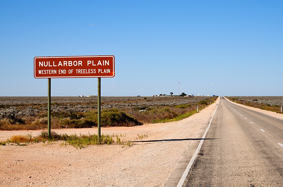
- (c)Nallarbar Plain — The Nullarbor Plain is one of the defining features of the Australian interior — a vast, almost treeless limestone platform on the Great Australian Bight, crossed by the Eyre Highway and by the longest straight stretch of railway in the world. Its very name is from the Latin for 'no tree'. It is Australian beyond dispute, so it cannot be the answer.
- (d)Eyr Lake — Lake Eyre — officially Kati Thanda–Lake Eyre — lies in the far north of South Australia and is Australia's largest lake when it fills, which happens only in years of heavy flooding upstream in the Channel Country. It holds the continent's lowest natural point, about 15 m below sea level. Again unambiguously Australian, and named after the explorer Edward John Eyre, whose name is also on the Eyre Peninsula and the Eyre Highway.
This is an odd-one-out question in world physical geography, and it is decided by the general principle that a name belongs to a region. Australia's classic physical features form a short and very examinable list: the Great Dividing Range along the east, the Nullarbor Plain and the Great Australian Bight in the south, the Great Victoria, Simpson and Gibson deserts in the interior, Lake Eyre and Lake Torrens in the endorheic basins, the Murray–Darling as the one major river system, Uluru in the Northern Territory and the Great Barrier Reef off Queensland. Against that list, an Asian river's name stands out at once — provided you can read the name correctly. The second, and more transferable, lesson is procedural rather than geographical: this paper is a facing-page bilingual booklet, English on one page and हिन्दी on the page opposite, and the two columns are independent renderings of the same item. When one column is ambiguous, the other is evidence, and reading it costs nothing.
Work the question in the order the option set allows. Eliminate what you are sure of first: Nullarbor and Lake Eyre are Australian, so the answer is (a) or (b) and the exercise is now a two-way choice. Then notice why the choice is hard — 'Salwin' and 'Salvin' are a single letter apart, and in Latin script that is exactly the kind of difference that looks like a printing slip rather than a real distinction. The temptation at that point is to declare the question defective and move on. Do not: turn to the facing page. साल्विन and सेल्विन are visibly different words in Devanagari, and each attaches to a real place — Salween in Asia, Selwyn in Queensland. The general rule is worth carrying into every bilingual paper: when the English is ambiguous, check the हिन्दी before concluding anything, including before concluding that a question is broken. On this paper the same check settles more than one item. It is also worth noting that the Commission's spellings throughout this paper are its own, and a candidate has to work with the text as printed rather than with the version they would have preferred.
- The Salween is an Asian river about 3,289 km long, rising in Tibet, flowing through Yunnan as the Nu Jiang, then through Myanmar to the sea at Mawlamyine, and forming part of the Myanmar–Thailand border; in China it is part of the Three Parallel Rivers of Yunnan World Heritage Site
- The Selwyn Range is an area of rugged highlands in Queensland, Australia
- The Nullarbor Plain is flat, almost treeless arid country of southern Australia on the Great Australian Bight, spanning South Australia and Western Australia, and is the world's largest single exposure of limestone bedrock
- Kati Thanda–Lake Eyre in Far North South Australia is an endorheic lake covering up to about 9,500 sq km when full, and contains the lowest natural point in Australia at approximately 15 m below sea level
- The booklet is bilingual with facing pages: option (A) is printed साल्विन (Salween) and option (B) सेल्विन (Selwyn), a distinction the English spellings do not carry
- Treating one of a near-identical pair of spellings as an obvious misprint and answering on that assumption instead of checking the other language column
- Assuming that because a feature is called a 'valley' or a 'mountain' the label is geographically exact; work from the name, not from the noun attached to it
- Forgetting that Lake Eyre is usually dry — it is Australia's largest lake only in flood years, which is why it is described as an ephemeral salt lake
BPSC likes the odd-one-out in world geography and prints it with the Commission's own spellings, which is exactly why the हिन्दी page has to be treated as part of the question rather than as a translation for other candidates. UPSC asks the same knowledge as association or exclusion too — which country the Mekong does not run through, which continent marsupials belong to — but its option sets are unambiguous in spelling, so the skill it rewards is purely the geography.
The great Asian river Mekong does not run through
- (a) China
- (b) Malaysia
- (c) Cambodia
- (d) Laos
Answer(b) Malaysia
The identical exclusion structure applied to the Salween's neighbour in South-East Asia — three items belong to the river's geography and one does not. Both questions are won by knowing where a named feature actually sits rather than by recognising the name.
A class of animals known as Marsupials is a characteristic feature of
- (a) Africa
- (b) Australia
- (c) South America
- (d) South-east Asia
Answer(b) Australia
The same continent-association test, run the other way: UPSC gives the feature and asks for the continent, this paper gives the continent and asks which feature does not belong. Both rest on holding a short list of what is characteristically Australian.
Consider the following statements : 1. Lake Victoria is the third largest freshwater lake in the world by surface area. 2. It is one of the great lakes of Africa. 3. It is bordered by four countries—Tanzania, Uganda, Rwanda and Kenya. 4. The only outflow from Lake Victoria is the Nile River, which exits the lake near Jinja, Uganda. Which of the above statements are incorrect?
- (a) 1 and 2
- (b) 2 and 4
- (c) 3 and 4
- (d) 1 and 3
Answer(d) 1 and 3
The 69th CCE tested world physical geography the same way — take a named lake and check whether the details attached to it are true of the right place. As with Lake Eyre here, the marks go to a student who has the world's major lakes located, sized and bordered correctly.
- practice — not a real PYQ
The Salween river flows through which group of countries ?
- (a)China, Myanmar and Thailand
- (b)India, Bangladesh and Myanmar
- (c)Laos, Cambodia and Vietnam
- (d)Nepal, India and Bangladesh
Answer(a) China, Myanmar and Thailand — it rises in Tibet, runs through Yunnan as the Nu Jiang, crosses Myanmar and forms part of the Myanmar–Thailand border before reaching the sea at Mawlamyine.
- practice — not a real PYQ
The lowest natural point of the Australian continent is at
- (a)the Nullarbor Plain
- (b)Kati Thanda–Lake Eyre
- (c)the Great Australian Bight
- (d)the Simpson Desert
Answer(b) Kati Thanda–Lake Eyre — about 15 m below sea level, the lowest natural point in Australia and the sink of a vast endorheic basin.