Raj Krishna Jha secured All India Rank 8 in UPSC CSE 2024 (Geography optional).
Two of his PW OnlyIAS Srijan Mains General Studies test copies are preserved here.
We read 2 of these booklets page by page — below is exactly what’s inside: the questions Raj attempted, the examples and quotations used, and how each answer was structured. Every copy is a free PDF.
Rank 8 · CSE 20242 free PDFsUpdated 29 Jun 2026
Inside Raj Krishna Jha’s answer copies
Raj Krishna Jha — Test 48 copy
GS Paper 3 (Disaster Management)
What’s inside this copy
▸Every answer opens with a quantified hook ('85% of geography vulnerable', '12% flood-prone', '7576 km coast') to frame the scale before arguing.
▸Consistent two-bucket categorisation (Natural vs Anthropogenic; Geological/Natural/Anthropogenic) gives clean, scannable structure across all seven answers.
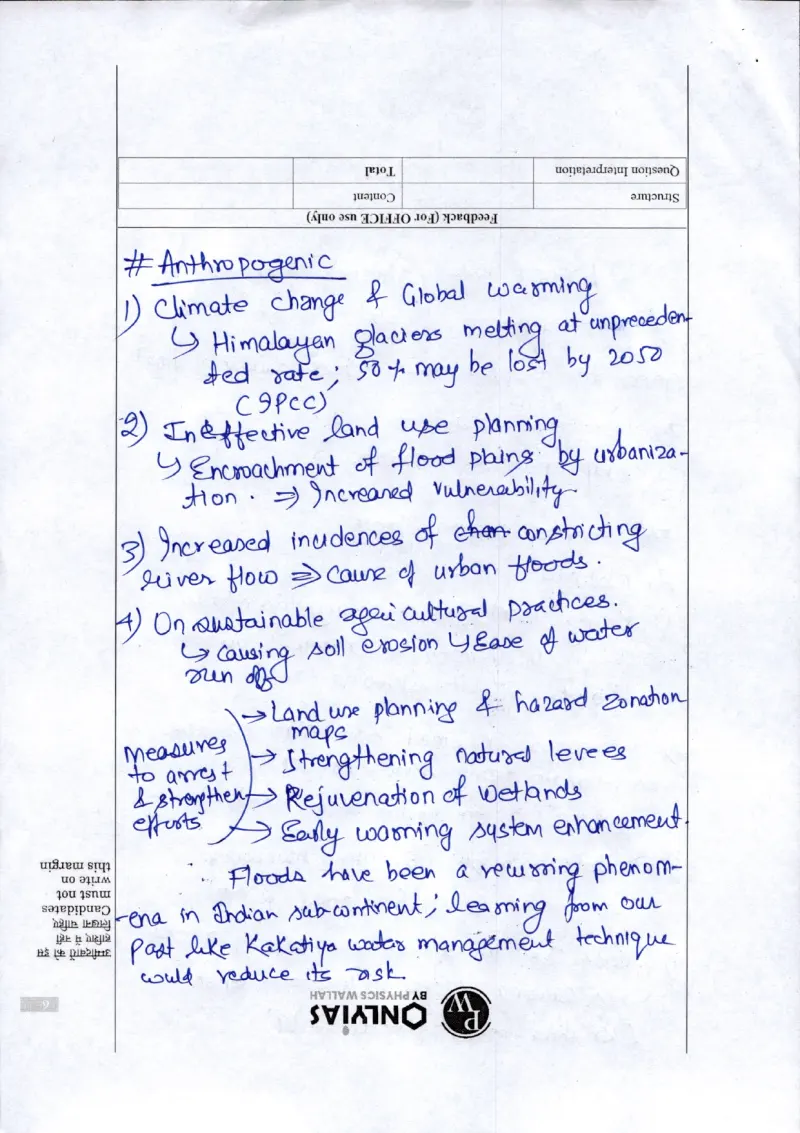
▸Dense, place-specific current examples — Wayanad 2024, Joshimath, Chamoli 2021, Sikkim 2021, Krishna floods 2019 — rather than generic statements.
▸Uses diagrams as analytical tools, not decoration: a labelled India vulnerability map (Q3) and a cold-wave temperature-criteria table (Q4).
▸Solutions consistently anchored to named frameworks and committees (Sendai, Hyogo, Yokohama, 2nd ARC, Gadgil & Kasturirangan).
▸Value-addition flair: a 'RESILIENT' mnemonic in Q6 and a 'glocalization' argument in Q7.
What to learn from this copy
★Every single answer opens with a quantified hook that frames the scale before any argument begins — '85% of geography vulnerable', '12% flood-prone', '7576 km coast', '40% of global cyclones occur at the Indian coast'. -> Don't start a GS3 answer with a definition; open with one hard statistic that quantifies the problem's magnitude, so the examiner sees you grasp the scale in the first line.
★Diagrams here do analytical work rather than decorate: a hand-drawn labelled outline MAP of India (Q3) marking distinct vulnerability zones (flood, landslide, cyclone, earthquake, tsunami, cloudburst, avalanche, desertification) captioned 'Fig: Vulnerability of India', and a TABLE of cold-wave criteria (Q4) giving the exact IMD thresholds (-4.5 to -6.4 deg C = cold wave; beyond -6.4 = severe). -> When a question is about spatial vulnerability or measurable categories, a labelled map or a criteria table conveys more, faster, than a paragraph — make the visual carry data, not just a generic flowchart.
★Solutions are consistently anchored to named frameworks and committees instead of vague suggestions — Sendai, Hyogo and Yokohama frameworks, 2nd ARC recommendations, and the Gadgil & Kasturirangan committees on the Western Ghats. -> Tie every 'way forward' to a specific report or framework by name; it signals you know the actual policy architecture rather than improvising remedies.
★Current examples are dense and place-specific, each tied to a precise failure mode — Wayanad landslides 2024 (>500 dead, flagged as 'lacking bottom-up approach'), Joshimath subsidence ('better land-use planning needed'), Chamoli cloudburst 2021, Sikkim landslide 2021, Krishna river floods 2019 ('steep gradient'). -> Stock 5-6 recent disasters and attach a one-phrase diagnosis to each, so the example doubles as evidence for your specific argument instead of being name-dropped.
★Answers run on a repeatable two-bucket spine — Natural vs Anthropogenic (and Geological/Natural/Anthropogenic for landslides) — and structural vs non-structural for measures (Q5's branching tree: Structural -> embankments, hydroseeding; Non-structural -> afforestation, terrace farming, contour bunds). -> A clean, pre-decided binary categorisation makes a 250-word answer instantly scannable and ensures you cover both sides without missing a dimension under time pressure.
★Value-addition is built in without padding — a 'RESILIENT' mnemonic to structure the 2nd ARC capacity-building answer (Q6) and a 'glocalization' framing (with CBDR, WHO, adaptation-mitigation) to critically examine localizing global DRR frameworks (Q7). -> One memorable coined term or acronym per high-mark answer gives the examiner a hook to remember your script by; deploy it sparingly on the 15-markers, not everywhere.
Questions attempted in this booklet (7)+
1.Paradigm shift in disaster management amid rising frequency of natural disasters (10 marks, 150 words)
How it’s written: Highly consistent, examiner-friendly template across all 7 answers: a one-line data-driven intro hook, then thematic sub-headings flagged with '#' (e.g. '#Factors causing flood', '#Need for a Paradigm shift', '#Comprehensive Measures'), numbered points each with a '↳' elaboration and an example. Strong bifurcation/c…
Diagrams & visuals: Q3: hand-drawn labelled outline MAP of India marking vulnerability zones (flood-prone, landslide, cyclone, earthquake, tsunami, cloud bursts, avalanches, desertification) — captioned 'Fig: Vulnerability of India'; Q4: a small TABLE of cold-wave criteria (temperature deviation from normal: -4.5 to -6.4°C = Cold wave; more than -6.4°C = Severe cold wave); Q5: branching/tree diagrams splitting measures into Structural (Artificial → embankments, hydroseeding) and Non-structural (Natural → afforestation, terrace farming, contour bunds & trench); Q7: a branching 'way forward' diagram fanning out glocalization sub-points (CBDR, proactive global orgs like WHO, adaptation & mitigation)
Evaluator: No examiner marks or comments are filled in on this copy.
▸Complete attempt: all 7 questions answered (Q1-Q4 at 10 marks, Q5-Q7 at 15 marks) on a single disaster-management/geography GS test (SRIJAN MAINS TEST-48).
▸Diagram-rich script: a hand-drawn India 'vulnerability' map (Q3), a temperature-threshold cold-wave flowchart (Q4), and tree/spider diagrams for flood causes and landslide threats.
▸Dense, current example bank: Wayanad 2024, Chamoli GLOF 2021, Joshimath subsidence, Cyclone Remal, Krishna floods 2019, Delhi 2023 fog.
▸Strong framework/institution vocabulary used as scaffolding: 2nd ARC, Sendai/Hyogo/Yokohama frameworks, Gadgil-Kasturirangan committee, NIDM, CDRI, CEED.
▸Memory-device structuring: spells out a vertical 'RESILIENT' acronym strategy for the Q6 capacity-building answer.
▸Q7 localization answer balances traditional knowledge (Johad, Assam bamboo huts) against global frameworks and lands on 'glocalization' / common-but-differentiated responsibility.
What to learn from this copy
★Raj Krishna pins almost every claim to a dated, named event rather than a vague reference: "Wayanad landslide 2024 (500+ dead)" and "Cyclone Remal" for landslides (Q5), "Krishna river floods 2019" and "Chamoli GLOF 2021" for floods (Q2), "Joshimath land subsidence" and "North India heatwaves 2023 (>100 killed)" for the paradigm-shift answer (Q1) -> Build a small bank of disaster/geography events tagged with year and a casualty/scale figure so you can drop a precise, recent illustration into each question instead of generic 'recent disasters'.
★He attributes statistics to a source to make them credible, not just impressive: "85% of India's area vulnerable to multiple hazards (CEED)", "Himalayan glaciers ~50% loss by 2050 (IPCC)", "~40% of global cyclones strike the Indian coast", "coastline of 7516 km" (Q1/Q3) -> Carry a handful of citable data points WITH their source body attached; a sourced figure reads as informed analysis rather than a number you invented.
★He converts the answer demand into a purpose-built visual instead of a decorative one: a labelled hand-drawn India 'Vulnerability' map zoning landslides, avalanches, desertification, earthquakes, tsunami/cyclone and flood-prone areas for the geographical-vulnerability question (Q3), and a cold-wave threshold flowchart (~-4.5 to -6.4 C = cold wave, below -6.4 C = severe) for the cold-wave question (Q4) -> Match the diagram to what the question actually asks — a spatial 'where' question earns a zoned map, a definitional question earns a threshold chart — so the visual carries content the examiner can score.
★He uses scaffolding vocabulary and a memory device to organise content under pressure: framework/institution names (2nd ARC, Sendai/Hyogo/Yokohama, Gadgil-Kasturirangan, NIDM, CDRI) act as ready sub-headings, and he spells out a vertical 'RESILIENT' acronym to structure the Q6 capacity-building answer -> Pre-bake one acronym or a fixed framework list per high-frequency theme so that under time pressure you instantly have your points and sub-headings rather than searching for structure.
★His Q7 'localization' answer earns its 'critically examine' verb by holding two sides in tension: indigenous practices (Johad water harvesting, Assam bamboo huts) set against global DRR frameworks, resolving on 'glocalization' and 'common-but-differentiated responsibility' rather than a one-sided verdict (Q7) -> For critically-examine questions, deliberately stage local-vs-global (or tradition-vs-formal) evidence and land on a synthesising concept, instead of just listing why the statement is true.
Questions attempted in this booklet (7)+
1.Disaster management needs a paradigm shift (reactive to proactive) given rising frequency of natural disasters; Comment (10 marks, 150 words)
2.Floods as a recurring disaster in India, driven by natural and anthropogenic factors; Discuss (10 marks, 150 words)
3.India's geographical location and the factors making it vulnerable to natural hazards; Discuss (10 marks, 150 words)
4.Factors behind increasing frequency/intensity of cold waves and their socio-economic impacts (10 marks, 150 words)
5.Landslides in hilly regions — intertwining causal factors and comprehensive risk-mitigation measures (15 marks, 250 words)
6.2nd ARC recommendations on disaster management and capacity building — challenges and measures to implement (15 marks, 250 words)
7.Success of global disaster-risk-reduction frameworks depends on their localization; Critically examine (15 marks, 250 words)
Cyclone Remal as cause of Meghalaya 2024 rainfall — Q5
Sikkim landslide 2021 — Q5
Krishna river floods 2019 — Q2
Coastal floods 2004 — Q2
North India heatwaves 2023 (cited >100 killed) — Q1
~40% of global cyclones striking the Indian coast — Q1
85% of India's area vulnerable to multiple hazards (attributed to CEED) — Q1/Q3/Q6
Coastline of 7516 km — Q3
Himalayan glaciers ~50% loss by 2050 (attributed to IPCC) — Q2
Polar vortex / North America blizzards — Q4
Cold-wave loss of 100+ lives in Bihar-UP and Delhi 2023 fog disruption — Q4
How it’s written: Highly structured, point-wise answers throughout. Each answer opens with a brief contextual intro, then a bold/underlined sub-heading (e.g. "# Intertwining factors", "# Challenges", "# Measures", "# Need for Globalisation"), followed by numbered points each with arrow (sub-bullet) elaborations and an example. Answer…
Diagrams & visuals: Hand-drawn outline map of India labelled 'Fig: Vulnerability of India' marking zones for landslides/cloudbursts, avalanches, desertification, earthquakes, tsunami/cyclones and flood-prone areas (Q3); Cold-wave criteria flowchart with temperature thresholds (roughly -4.5 to -6.4 C = cold wave; below -6.4 C = severe cold wave) (Q4); Branch/tree diagram of flood causes split into natural vs anthropogenic factors (Q2); Spider/tree diagram of landslide threats (loss of life, infrastructure damage, agricultural submergence, sedimentation floods, damage to flora/fauna) (Q5); Branch diagram of structural measures (Artificial: embankments, hydroseeding; Natural: afforestation, terrace farming, contour bunds & trenches) (Q5); Branch 'way forward' diagram (glocalization, common-but-differentiated responsibility, proactive role of WHO, adaptation & mitigation per Sendai) (Q7)
Evaluator: No examiner marks or comments are filled in on this copy.
How many Raj Krishna Jha answer copies can I download here?+
This page links to 2 of Raj Krishna Jha's mains answer copies (General Studies) as free PDFs, from the UnlockIAS topper-copy archive. Each opens in Google Drive — no sign-up or payment.
What rank did Raj Krishna Jha get and in which year?+
Raj Krishna Jha secured Rank 8 in UPSC CSE 2024.
Are Raj Krishna Jha's answer copies evaluated with marks?+
These are Raj Krishna Jha's test-series mains booklets. Most are clean (unmarked) fair copies — their value is in the actual answers: the questions attempted, the examples and quotations used, and how the answers are structured, which we summarise on this page. A few topper copies in the wider library do carry the evaluator's qualitative feedback.
What can I learn from Raj Krishna Jha's answer copies?+
Decode the pattern, don't copy the content. For example, in Raj Krishna Jha's copies: every answer opens with a quantified hook ('85% of geography vulnerable', '12% flood-prone', '7576 km coast') to frame the scale before arguing.. Read a copy, then write the same question yourself and compare structure, example density and conclusion quality.
Are these Raj Krishna Jha copies really free?+
Yes — every PDF on this page is free to view and download. UnlockIAS hosts this index for free educational use; credit for each booklet belongs to the candidate and the evaluating test series.
Studying Raj Krishna Jha's copies shows you the target; the Sherlocking Mains programme trains you to hit it — daily answer writing with AWE Bot evaluation and mentorship. Or get one Mains answer evaluated free.