
Akshat Jain — answer booklet 6

What’s inside this copy
- ▸Attempts all 20 questions fully (ten 150-word + ten 250-word answers) with no blank/skipped answers and consistent point-form layout.
- ▸Nearly every answer names a specific scheme, rule or report rather than staying generic — e.g., Plastic Waste Management Rules 2016, ECBC 2017, Wetland Rules 2017, PAT scheme/BEE, HELP Policy, TAMRA portal.
- ▸Anchors introductions to a cited source or governing law (State of Environment Report 2017, ISRO Atlas on Desertification, Forest Rights Act 2006) before listing causes.
- ▸Uses memorable structuring devices: a hand-drawn branching tree for ecosystems in the sand-mining answer (Q12) and a '3 Is' (Infrastructure–Investment–Innovation) framework for strategic minerals (Q19).
- ▸Underlines scheme names and key phrases throughout to make answers scannable for the examiner.
- ▸Geography answers consistently tie theory to concrete Indian locations — Chhotanagpur (iron & steel/heavy), Vindhyan ranges (cement), Odisha (bauxite/aluminium), Bangalore–Hyderabad (IT).
What to learn from this copy
- ★Almost every answer is anchored to a named scheme, rule, report or law instead of generic discussion -- Plastic Waste Management Rules 2016 (with its actual provisions: segregation at source, brand-owner responsibility, integrating ragpickers/kabadiwalas), ECBC 2017, Wetland (Conservation and Management) Rules 2017, the PAT scheme run by BEE with its Energy Saving Certificates, the TAMRA portal and Mining Surveillance System. -> Don't describe a policy area in the abstract; name the exact rule/scheme AND one or two of its real mechanisms -- that specificity is what separates a topper answer from a textbook paraphrase.
- ★He opens answers by citing the governing source before listing causes -- e.g. anchoring the desertification answer to the 'State of Environment Report 2017' (eight worst states: Haryana, Punjab, Rajasthan, MP) and 'ISRO's Atlas on Desertification', and the JFM answer to the Forest Rights Act 2006. -> Lead your intro with a named, datable source rather than a definition; it instantly signals authority and frames everything that follows.
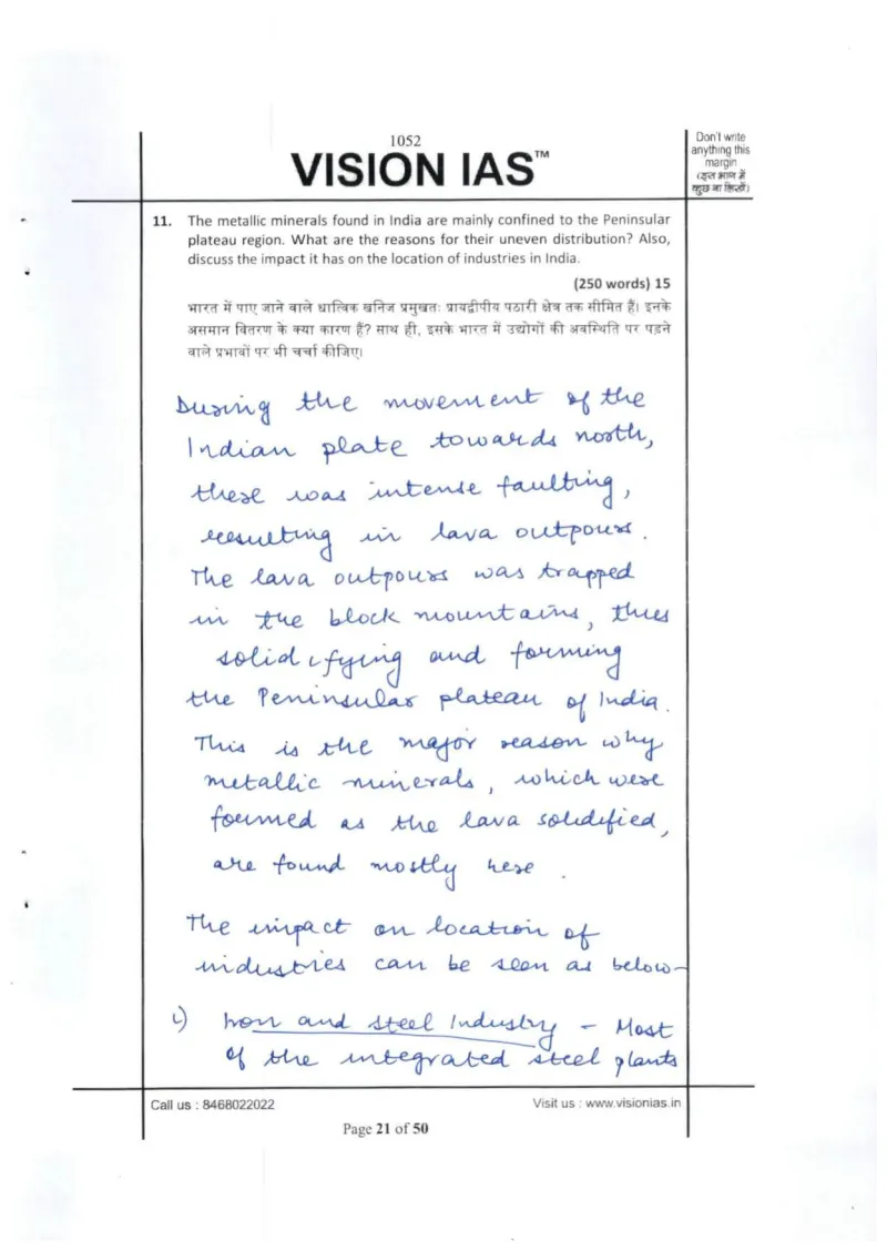
- ★Geography theory is tied to concrete Indian locations in nearly every answer -- Chhotanagpur plateau for iron & steel/heavy industry, Vindhyan ranges for cement/limestone, Odisha bauxite for aluminium, copper in MP & AP, uranium in AP/Jharkhand/Meghalaya, Bangalore-Hyderabad for IT. -> For location/distribution questions, attach each general factor to a specific named place; a list of real locations proves command of the map far better than naming the factor alone.
- ★He builds his own memorable structuring devices instead of just listing -- the '3 Is' framework (Infrastructure, Investment, Innovation) as underlined sub-headings for the strategic-minerals answer (Q19), and a hand-drawn branching tree in Q12 fanning 'Ecosystems harmed by it' out to coastal ecosystem, mangroves, continental shelves, estuaries and lagoons. -> A short self-coined mnemonic or a simple branching diagram organises a generic answer into something the examiner can grasp and reward at a glance.
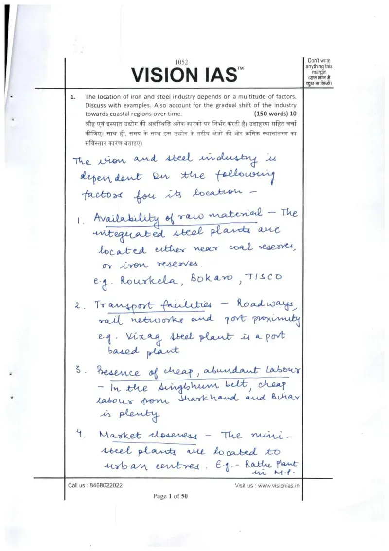
- ★On steel-plant location he goes past raw cost factors to note that 'Bokaro was set up to develop the backward Jharkhand region' and that Singhbhum drew cheap labour from Jharkhand & Bihar. -> Add the policy/regional-development 'why' behind a location, not just the resource endowment -- showing that siting decisions also serve backward-area development adds an analytical layer most answers miss.
Questions attempted: Iron & steel industry location factors + gradual shift to coastal regions (150w); Regions affected by desertification in India, reasons, effectiveness of steps (150w); 'Golden fibre' (jute) industry distribution change over 50 years, decline reasons, revival measures (150w), and 17 more below.
Questions attempted in this booklet (20)+
- 1.Iron & steel industry location factors + gradual shift to coastal regions (150w)
- 2.Regions affected by desertification in India, reasons, effectiveness of steps (150w)
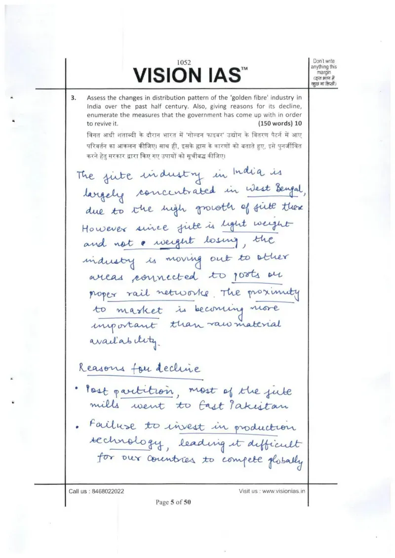
- 3.'Golden fibre' (jute) industry distribution change over 50 years, decline reasons, revival measures (150w)
- 4.Footloose industry examples + significance for India (150w)
- 5.Shale gas — identifying basins & acquiring extraction technology, challenges (150w)
- 6.Plastic waste as urban environmental/health problem + Plastic Waste Management Rules 2016 (150w)
- 7.Energy efficiency in buildings in urbanization strategy + ECBC 2017 (150w)
- 8.PAT scheme making energy efficiency attractive, performance, improvement measures (150w)
- 9.Household/indoor air quality (rural), challenges, measures (150w)
- 10.Joint Forest Management (JFM) + potential to improve forest-dweller livelihoods (150w)
- 11.Metallic minerals confined to Peninsular plateau — reasons for uneven distribution + impact on industry location (250w)
- 12.Sand & gravel mining threatening ecosystems + MoEFCC guidelines for sustainable mining (250w)
- 13.Critical analysis of Wetland (Conservation and Management) Rules 2017 (250w)
- 14.Garbage processing/safe disposal vs landfills for 'smart' cities + reasons for waste-policy failure (250w)
- 15.Worsening North India smog despite govt/judicial action + feasible steps (250w)
- 16.Why fishing skewed to higher latitudes; global fishery challenges; international bodies' measures (250w)
- 17.Why some areas attract industry despite similar endowments + major industrial regions of India (250w)
- 18.Biofuel — economic, environmental and social sustainability debate (250w)
- 19.Strategic minerals — exploration/production challenges + approach ('3 Is') (250w)
- 20.Fertilizer plant location vs oil refineries/coal areas + siting near consumers (UP) (250w)
Examples, data & evidence used
- Steel plants: Rourkela, Bokaro, TISCO (near coal/iron); Visakhapatnam (Vizag) as port-based plant; Singhbhum belt with cheap labour from Jharkhand & Bihar; Bokaro set up to develop backward Jharkhand region (Q1)
- State of Environment Report 2017 — eight states with large desertified areas: Haryana, Punjab, Rajasthan, Madhya Pradesh among others (Q2)
- ISRO's Atlas on Desertification (Q2)
- National Action Plan to Combat Desertification (Q2)
- National Jute Policy — jute bags promoted in retail in place of plastic (Q3)
- Plastic Waste Management Rules, 2016 — segregation at source, brand-owner responsibility, integrating ragpickers/kabadiwalas (Q6)
- National Mission on Enhanced Energy Efficiency; Energy Conservation Building Code (ECBC) 2017 (Q7)
- PAT (Perform, Achieve and Trade) scheme implemented by BEE; Energy Saving Certificates trading (Q8)
- LPG/PNG as cleaner cooking alternatives; behavioural economics 'nudge' (Q9, also Q15)
- Forest Rights Act, 2006 cited as basis for JFM; NGOs as stakeholders (Q10)
- Mineral-industry geography: Chhotanagpur plateau (iron & steel, heavy industry), Vindhyan ranges (cement/limestone), Odisha bauxite (aluminium), copper in M.P. & A.P., uranium in A.P./Jharkhand/Meghalaya for nuclear plants (Q11)
- MoEFCC sand-mining guidelines: mandatory EIA, continuous monitoring, geo-tagging of mines, District Mineral Foundation (royalty %), ban on outdated equipment; TAMRA portal & Mining Surveillance System (Q12)
- UNEP report on wetland loss; Wetland (Conservation and Management) Rules 2017 superseding 2016 rules; State Wetlands Authority (SWA); National Wetlands Committee replacing Central Wetlands Regulatory Authority; 'wise use' principle; Ramsar wetlands; salt pans excluded; comparison with 2010 rules (Q13)
- Smart Cities Mission; Solid Waste Management Rules (SWM) 2016; Windrowing technique; NITI Aayog; waste-to-energy incinerators, composting/bioremediation, nanotechnology; Swachh Bharat Mission (Q14)
How it’s written: Highly disciplined, exam-oriented structure. Each answer opens with a 1-2 line context/definition that frequently anchors to a named source or governing law (e.g., "As per the State of Environment Report 2017...", "The Forest Rights Act 2006 calls for JFM..."). The body is almost entirely point-form: numbered lists…
Diagrams & visuals: One genuine hand-drawn branching tree/flow diagram in Q12: a boxed node 'Ecosystems harmed by it' with downward branches to Coastal ecosystem, Mangroves, Continental shelves, Estuaries, and High-land & lagoons; Q19 presents a labelled '3 Is' framework (i) Infrastructure (ii) Investment (iii) Innovation as underlined sub-headings introduced with 'as shown below' — a structuring mnemonic rather than a drawn chart; No maps drawn; remaining answers are point-form text with underlined keywords, no tables
Evaluator: No examiner marks or comments are filled in on this copy.