
UPSC Current Affairs

12 topicsGS-1: 5GS-2: 2GS-3: 5
0/12 done
GS-2Polity

1.Implementation of Four Labour Codes (Labour Codes)

Indian Express
Illustration for Implementation of Four Labour Codes (Labour Codes)

What & Where

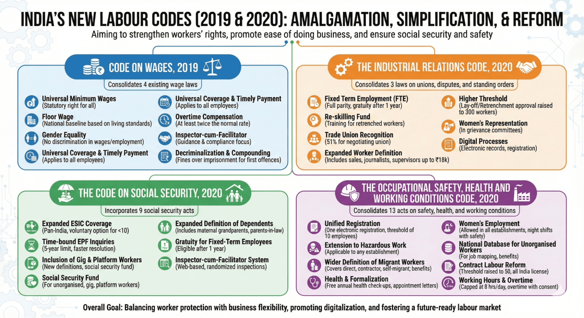
Labour Codes: four unified Acts (Code on Wages 2019; IR, Social Security, OSH 2020) covering wages, relations, safety, security

Geography: pan-India applicability; States draft subsidiary rules since labour is Concurrent List

Aim: reduce 29 fragmented laws, boost formalisation, worker welfare, investment climate

Quick Facts for MCQs

Major Provisions

  • Wage: uniform definition, gender-neutral, floor wage barring lower state rates
  • Safety: OSH applies even single-employee high-risk units, night work allowed for consenting women with safeguards
  • Social security: EPF inquiry time-bar five years, travel accidents deemed employment injuries

Key Concerns

  • Compliance: MSMEs face higher PF, ESIC, safety costs potentially curbing hiring
  • Representation: 51 % single-union rule may sideline smaller unions, trigger disputes
  • Fixed-term misuse: repeated contracts could erode job security, increase litigation

Constitutional Basis

  • Equality Articles 14-18 support non-discrimination in wages, hiring
  • Article 19(1)(c) safeguards trade-union formation, informing IR Code provisions
  • Article 23 interpreted by SC: below-minimum wage equals forced labour

Implementation Needs

  • Uniform rules: model rulebook, inter-state council to avoid regulatory mosaic
  • MSME support: digital helpdesks, temporary EPF co-payment for smooth transition
  • Gig coverage: dedicated national policy mandating aggregator social-security contribution

Key Data Points

FeatureData-Point
Earlier central labour laws merged29
Statutory floor wage set byCentral Government
Retrenchment permission ceiling raised to300 workers
Daily work limit8 hours; 48 hours/week
Overtime pay rate2× normal wage
Gratuity for Fixed-Term EmployeeEligible after 1 year service
ESIC coverageAll India; hazardous units compulsory
New beneficiaries definedGig, platform, unorganised workers
Reskilling fund per retrenched worker15 days wages within 45 days
Social Security Fund financingCompounding penalties + aggregator contribution

Related UPSC Prelims PYQs

CAPF_GAI, CDS_GK 2022PYQ 1

भारत सरकार द्वारा अधिसूचित निम्नलिखित श्रम संहिताओं में से किसमें केंद्रीय श्रम अधिनियमों, यथा कारखाना अधिनियम, 1948 और खदान श्रम अधिनियम, 1951 के विशेष उपबंध को शामिल किया गया है?

CAPF_GAI, CDS_GK 2025PYQ 2

The Code on Wages was notified by the Government of India in the year

GS-1History

2.Punjab Sikh Holy Cities (Sikh Holy Cities)

Indian Express

What & Where

Holy-city resolution: Punjab Assembly designates Amritsar Walled City, Anandpur Sahib, Talwandi Sabo as sacred zones.

Prohibition: Liquor, meat, tobacco, other intoxicants barred within notified precincts.

Heritage: Sites house 3 of 5 Sikh Takhts; remaining Takhts in Patna (Bihar) and Nanded (Maharashtra).

Quick Facts for MCQs

Legal & Policy

  • Resolution-based ban empowers local bodies to halt licensing for alcohol, meat, tobacco outlets.
  • Classification as holy city enables stricter municipal bylaws under Punjab Municipal Act.
  • No penalty clauses yet announced; enforcement to rely on excise, police coordination.

Cultural Significance

  • Commemoration links city status to Guru Tegh Bahadur’s martyrdom narrative.
  • Takhts embody miri-piri doctrine, blending temporal and spiritual Sikh authority.
  • Sites attract annual pilgrim influx, bolstering religious tourism identity.

Geography & Sites

  • Punjab hosts three Takhts within 200 km radius, easing pilgrim circuits.
  • Non-Punjab Takhts extend Sikh heritage corridor to eastern (Patna) and southern (Nanded) India.
  • Amritsar Walled City boundaries align with historic 17th-century fortifications.

Key Data Points

FeatureData-Point
Resolution occasion350th martyrdom anniversary of Guru Tegh Bahadur
Assembly statePunjab
Declared holy citiesAmritsar Walled City, Anandpur Sahib, Talwandi Sabo
Banned itemsLiquor, meat, tobacco, intoxicants
Akal TakhtAmritsar; est. 1606 by Guru Hargobind; apex Sikh authority
Takht Sri Keshgarh SahibAnandpur Sahib; Khalsa creation 1699
Takht Sri Damdama SahibTalwandi Sabo; Guru Gobind Singh finalised scripture
Takht Sri Patna SahibPatna; birthplace Guru Gobind Singh
Takht Sachkhand Hazoor SahibNanded; Guru Gobind Singh’s final days & cremation 1708
GS-1Polity

3.Mekedatu Dam River Dispute (Cauvery Dispute)

The Hindu
Illustration for Mekedatu Dam River Dispute (Cauvery Dispute)

What & Where

Mekedatu: proposed balancing reservoir in deep Cauvery–Arkavathi gorge near Kanakapura, Ramanagara district, Karnataka.

Purpose: supply drinking water to Bengaluru-metropolitan area and produce 400 MW hydro-power.

Dispute: downstream Tamil Nadu fears curtailed flows; issue sits within larger Cauvery inter-state water conflict.

Quick Facts for MCQs

Legal & Policy

  • Agreement: 1892 & 1924 Madras–Mysore pacts mandate upper-state consent for projects.
  • Tribunal: CWDT set up under Inter-State River Water Disputes Act, 1990.
  • SupremeCourt: 2018 verdict largely upholds CWDT award; orders CWMA creation.

Project Specifications

  • Storage: revised DPR to be resubmitted by Karnataka to Union Jal Shakti Ministry.
  • Power: envisages 2 × 200 MW turbines within gorge.
  • Classification: Central Water Commission clearance pending.

Inter-State Relations

  • Opposition: Tamil Nadu cites reduced irrigation flow, irregular releases, excess upstream storage.
  • Coordination: CWMA monthly meetings monitor release compliance among four riparian states.
  • Federalism: Mekedatu issue tests cooperative federal ethos between Karnataka & Tamil Nadu.

Historical Timeline

  • 150-year legacy: dispute traces back to colonial-era agreements.
  • 1974 flashpoint: Karnataka began diversions without Tamil Nadu consent, reigniting conflict.
  • 2025 status: Karnataka preparing revised DPR amid continuing objections.

Key Data Points

FeatureData-Point
Project typeBalancing reservoir + hydro station
Main riverCauvery
Tributary confluenceArkavathi
Installed capacity400 MW (proposed)
DistrictRamanagara, Karnataka
Primary benefitBengaluru drinking water
Lower riparian stateTamil Nadu
Tribunal formed1990 (CWDT)
CWDT Final Order2007
SC landmark case2018; Cauvery called “national asset”
Implementing agencyCauvery Water Management Authority
Union List entryEntry 56 (inter-state rivers)
State List entryEntry 17 (Water)

Related UPSC Prelims PYQs

GS1, NDA_GAT 2020PYQ 1

Krishna Raja Sagara Dam/Reservoir is developed on

GS1, NDA_GAT 1999PYQ 2

Match List I with List II and select the correct answer using the codes given below the Lists:

GS-1Environment

4.Fujiwhara Effect Cyclone Interaction (Cyclone Interaction)

Down to Earth
Illustration for Fujiwhara Effect Cyclone Interaction (Cyclone Interaction)

What & Where

Fujiwhara Effect: mutual rotation of two tropical cyclones around a common centre when ≤ ~1,400 km apart

Mostly observed in Bay of Bengal, NW Pacific & other tropical cyclone belts

Named after Japanese meteorologist Sakuhei Fujiwhara, described in 1921

Quick Facts for MCQs

Formation Factors

  • Proximity: nascent storms spawn within monsoon trough or ITCZ, shrinking gap below ~1,400 km
  • Warm-pool: Bay of Bengal maintains >28 °C SST Oct–Nov, fuelling sustained convection
  • Symmetry: similar coriolis-induced spin eases coupling of outer rainbands

Interaction Outcomes

  • Orbiting: weaker vortex circles dominant one; may be absorbed due to energy imbalance
  • Merger: core centres coalesce, producing larger, more intense cyclone with enhanced rainfall
  • Divergence: sub-critical interaction pushes tracks apart, injecting forecast uncertainty

Forecasting Issues

  • Track unpredictability: standard steering-flow models struggle once circulations overlap
  • Warning delays: shifting landfall zones hinder timely evacuation planning for E-coast states
  • Rainfall persistence: stalling systems prolong deluge, amplifying flood hazard in TN, AP, Odisha, Bengal

Impact Zones

  • High-risk shores: Tamil Nadu, Andhra Pradesh, Odisha, West Bengal, Sri Lanka & Myanmar
  • Flood potential: prolonged cloud-bands dump extreme 24-hr totals over coastal plains & deltas
  • Storm surge: merged or intensified systems elevate coastal inundation beyond single-storm norms

Key Data Points

FeatureData-Point
Threshold proximity~1,400 km (Indian Ocean benchmark)
Required sea-surface temp.> 26 °C
Wind shear conditionLow vertical shear favours interaction
Rotation direction in N HemiCounter-clockwise
First identification year1921
Possible end-statesOrbiting, merger, weakening, deflection
GS-1Mapping

5.Hayli Gubbi Volcano Eruption (Shield Volcano)

NDTV
Illustration for Hayli Gubbi Volcano Eruption (Shield Volcano)

What & Where

Hayli Gubbi: broad, gently sloping shield volcano built by low-viscosity basaltic lava.

Sited in Afar Depression, Ethiopia, at southern tip of Erta Ale range.

Occupies East African Rift divergent boundary between African & Arabian plates.

Quick Facts for MCQs

Geological Context

  • Rift: Afar triple-junction links Red Sea, Gulf of Aden, East African Rifts.
  • Range: Erta Ale segment among world’s most active tectonic belts.
  • Morphology: Extensive lava fields, low gradient unlike stratovolcanoes.

2025 Eruption Details

  • Dormancy broken by sudden sub-plinian blast on 23 Nov 2025.
  • Column soared to FL450, dispersing particles thousands of kilometres.
  • Ejecta pose aviation risk; glassy ash damages jet turbines.

Indian Impact

  • Air quality: Ash stays 15–45 k ft, negligible ground-level AQI change in Delhi.
  • Visibility: Possible hazy, darker skies; slight solar attenuation.
  • Health: SO₂ concentrations low; minimal acid-rain threat.

African Volcanoes

  • Active: Nyiragongo (DR Congo) noted for fastest known lava flows.
  • Rift members: Dabbahu, Alayta, Asavyo within Ethiopian sector.
  • Others: Ardoukoba (Djibouti 1978), extinct Silali caldera (Kenya).

Key Data Points

FeatureData-Point
Volcano typeShield
Region-CountryAfar Region, Ethiopia
Plate settingDivergent; African Plate rifting
Dormancy length~10,000–12,000 years
23 Nov 2025 eruptionSub-plinian
Plume top altitude≈ 45,000 ft (FL450)
Ash drift routeEthiopia → Red Sea → Yemen/Oman → W. India
Main ejectaAsh, SO₂, glass shards, rock fragments
GS-3Environment

6.Air Quality Monitoring Systems (Air Pollution Monitoring)

Indian Express
Illustration for Air Quality Monitoring Systems (Air Pollution Monitoring)

What & Where

Air Quality Monitoring: systematic pollutant measurement to enforce 2009 NAAQS across India.

Key device types: CAAQMS (real-time), manual gravimetric stations, low-cost sensors.

Dense CAAQMS network in Delhi—40 stations under CPCB/SPCB oversight.

Quick Facts for MCQs

Technology & Instruments

  • CAAQMS cabins: temperature-controlled, dust-proof, remote-telemetry enabled.
  • Low-cost sensors: dense spatial mapping but need calibration with reference-grade devices.
  • NOx measured via chemiluminescence; NH₃ by optical spectroscopy.

Operational Challenges

  • High humidity (>60 %) causes beta-gauge PM overestimation.
  • Power cuts, equipment failure create data gaps; several Delhi sites miss CPCB 16-hour rule.
  • Poor siting near obstructions distorts airflow, skewing readings.

Legal & Policy

  • Supreme Court demanded equipment details, suitability for Delhi’s extreme weather.
  • CPCB 2012 protocol standardises calibration, sampling and QA/QC for CAAQMS.

Key Data Points

FeatureData-Point
National standardNAAQS 2009
Real-time station nameCAAQMS
Delhi CAAQMS count40 (largest in India)
Pollutants tracked (CAAQMS)PM2.5, PM10, NO₂, SO₂, CO, O₃, NH₃, Pb
PM analyser techBeta Attenuation Monitor (BAM)
SO₂ analyser techUV fluorescence
CO analyser techNon-Dispersive Infrared absorption
Data validity norm≥16 hrs/day of good data (CPCB)

Related UPSC Prelims PYQs

GEO_GS, GS1 2022PYQ 1

WHO के वायु गुणवत्ता दिशानिर्देशों के संदर्भ में, निम्नलिखित कथनों पर विचार कीजिए :

GEO_GS, GS1 2020PYQ 2

Which of the following particulate matters (size based) are notified pollutants in National Ambient Air Quality Standards (NAAQS)?

GS-3Mapping

7.Ningaloo Reef Marine Heatwave Impact (Coral Reef)

Down to Earth
Illustration for Ningaloo Reef Marine Heatwave Impact (Coral Reef)

What & Where

Definition: Ningaloo Reef — Australia’s largest fringing coral reef, part of Ningaloo Coast UNESCO World Heritage Area.

Geography: 260 km near-shore reef along northwest Western Australia, ~1,200 km north of Perth, East Indian Ocean.

Formation: Millennia of coral limestone accretion on shallow shelf, aided by Cape Range uplift and stable sea levels.

Quick Facts for MCQs

Environmental Impact

  • Heatwave: 2024–25 most intense, causing widespread bleaching, dead skeletons colonised by sponges, algae, invasives.
  • Oxygen decline: 2022 hypoxia dropped live coral cover from 70 % to 1 % at some sites.
  • Structural loss: Dead frameworks weaken habitat, threaten associated megafauna like whale sharks, turtles.

Biodiversity Highlights

  • Megafauna: Seasonal aggregations of whale sharks, manta rays, humpback whales, nesting turtles.
  • Coral diversity: Intact shallow-water assemblages unusually close to mainland coast.
  • Islands: Muiron Islands within property add additional reef, seabird roosting sites.

Cultural & Economic Angle

  • Indigenous ties: Baiyungu, Jinigudira peoples retain cultural custodianship and archaeological sites.
  • Eco-tourism: Reef underpins local economy via diving, whale-shark tours, generating significant regional revenue.

Climate Trend Data

  • Warming seas: 2023 hottest ocean year on record, setting conditions for repeated marine heatwaves.
  • Frequency: Heatwaves now longer, more intense, increasing stress on even resilient high-latitude reefs.

Key Data Points

FeatureData-Point
Reef length~260 km
Distance from Perth~1,200 km north
Ocean basinEast Indian Ocean
UNESCO inscription year2011
Coral mortality 2024–25Up to 70 %
2023 marine heatwave duration4 × longer than average
Global oceans affected 202396 %
Main bleached genusStaghorn corals
Annual tourists≈ 200,000
Indigenous occupation evidence> 32,000 years

Related UPSC Prelims PYQs

CDS_GK, NDA_GAT 2021PYQ 1

Keppel Island is completely bleached mainly due to the expansion of

CDS_GK, NDA_GAT 2020PYQ 2

The largest barrier reef system in the world is found at

GS-3S&T

8.In-Flight Internet Systems (In-flight Wi-Fi)

The Hindu
Illustration for In-Flight Internet Systems (In-flight Wi-Fi)

What & Where

Definition: Onboard Wi-Fi providing Internet by relaying data to ground via aviation-certified Air-to-Ground or satellite links

Systems: ATG uses land cell towers; satellite systems (GEO, LEO) ensure coverage over oceans, deserts, polar regions

Geography: Works worldwide at cruising altitudes (~30,000 ft), with satellites routing traffic through ground teleport stations to fibre backbones

Quick Facts for MCQs

Technology Mechanics

  • Workflow: Passenger device→cabin Wi-Fi→onboard server→ATG or satellite antenna→ground Internet backbone
  • Management: Server enforces login, identity verification, usage policies, bandwidth prioritisation
  • Intermediary: GEO or LEO satellites bounce data between aircraft and ground teleport stations

Performance Constraints

  • Bandwidth: Single link shared among all passengers, speed drops during high simultaneous demand
  • Latency: GEO path induces ~500–700 ms round-trip delay, affecting real-time apps
  • Variability: Weather, route changes, satellite congestion impact throughput stability

Cost & Operations

  • Expense: Antennas, avionics certification, satellite bandwidth leases significantly raise airline operating cost
  • Optimisation: Dynamic bandwidth allocation across multiple aircraft matches demand with paid capacity
  • Traffic-shaping: System blocks VoIP, compresses images, limits streaming to conserve scarce bandwidth

Key Data Points

FeatureData-Point
System typesATG, Satellite (GEO/LEO)
ATG coverageLand areas only
Satellite coverageOceanic, desert, polar routes
Satellite antennaDome-mounted on fuselage
ATG antennaUpward-facing underbelly
GEO orbit altitude≈36,000 km
GEO latency500–700 ms
Connectivity altitude>30,000 ft
Onboard Wi-Fi nodesCeiling-mounted access points
LEO advantageLower latency, higher speed
GS-3S&T

9.HAMMER Precision Guided Munition (Precision Munition)

The Print
Illustration for HAMMER Precision Guided Munition (Precision Munition)

What & Where

Weapon: HAMMER (Highly Agile Modular Munition Extended Range), precision-guided air-to-ground bomb kit.

Location: To be co-manufactured in India by BEL–Safran JV, ~60 % localisation planned.

Use-case: Stand-off strikes (≤70 km) against hardened targets; suited for mountainous theatres like Ladakh.

Quick Facts for MCQs

Tech & Schemes

  • Modular-kit design; converts standard 250–1000 kg bombs into smart munitions.
  • Agility algorithms enable steep-angle attack; vital for valley or hardened bunker strikes.
  • JV aligns with Make-II category of Defence Acquisition Procedure.

Economic Angle

  • Local assembly cuts foreign exchange outgo; lowers life-cycle cost.
  • Potential export hub; BEL to leverage existing global marketing channels.
  • Indigenous supply chain spurs MSME participation in seekers, propulsion, electronics.

Security Dimension

  • Stand-off capability keeps launch aircraft outside adversary SAM envelopes.
  • Precision limits collateral damage; useful for politically sensitive engagements.
  • Rapid domestic availability avoids emergency imports during crises.

International Collaboration

  • France retains technology leadership; transfers manufacturing know-how to India.
  • Reflects deepening Indo-French defence partnership post-Rafale deal.
  • Model may replicate for future Safran systems like AASM or guidance kits.

Key Data Points

FeatureData-Point
Original developerSafran (Sagem), France
Indian partnerBharat Electronics Limited (BEL)
Guidance modesGPS/INS, Infra-red, Laser
Maximum stand-off range≈ 70 km
ArchitectureModular guidance + range-extension kit on GP bombs
Compatible IAF aircraftRafale, LCA Tejas (planned)
Local content target≈ 60 %
Terrain optimised forHigh-altitude, complex topography

Related UPSC Prelims PYQs

CDS_GK, ESE_GS 2025PYQ 1

भारत के सैन्य आयुध (military arsenal) के बारे में निम्नलिखित में से कौन-सा/कौन-से कथन सही है/हैं?

CDS_GK, ESE_GS 2024PYQ 2

Ministry of Defence signed contract with which one of the following organizations for Upgraded Super Rapid Gun Mount (SRGM) and other equipment for around 3000 crores?

GS-2Misc

10.IBSA Dialogue Forum Overview (IBSA Forum)

Indian Express

What & Where

Tri-continental democratic forum: India-Brazil-South Africa; voice of Global South.

Formalised 6 June 2003 via Brasilia Declaration; no headquarters or permanent secretariat.

Work pillars: political consultation, trilateral working-groups/people forums, South-South projects via IBSA Fund.

Quick Facts for MCQs

Development Cooperation

  • IBSA Fund channels pooled grants for health, education, agriculture in partner LDCs.
  • IBSAMAR drills build maritime interoperability and Indian Ocean–South Atlantic presence.
  • 2025 proposals widen scope to climate-smart farming and export of Indian DPI platforms.

Indian Stakes

  • Leadership; IBSA lacks China, letting India shape Global South agenda.
  • UNSC reform push amplifies India’s permanent-seat campaign.
  • Forum showcases UPI, CoWIN, cybersecurity as scalable democratic tech.

Key Roadblocks

  • Geopolitical divergence: Brazil’s policy swings; South African instability; varied China postures.
  • Agenda duplication with an expanding BRICS saps political capital.
  • No permanent secretariat; thin trade links hinder project execution.

Future Pathways

  • Establish lean secretariat and IBSA Business Council for supply-chain mapping.
  • Use IBSA caucus inside BRICS to balance China-Russia weight.
  • Revitalize Fund; co-deliver green energy and DPI models to Global South.

Key Data Points

FeatureData-Point
MembersIndia, Brazil, South Africa
Formation6 Jun 2003, Brasilia
Current chair (2025)South Africa
SecretariatNone; rotating stewardship
IBSA Fund launch2004; operational 2006
Fund outlayUSD 53.27 mn for 46 projects in 34 LDCs
Naval exerciseIBSAMAR
8th IBSAMAROct 2024, off South Africa
Proposed 2025 ideasNSA-level dialogue; Climate-Resilient Agri Fund; Digital Innovation Alliance
Overlap blocBRICS (includes China)

Related UPSC Prelims PYQs

CDS_GK, GS1 2023PYQ 1

The joint multinational maritime exercise named IBSAMAR is conducted by the Navies of which of the following countries?

CDS_GK, GS1 2025PYQ 2

Consider the following statements with regard to BRICS:

GS-3Security

11.Exercise Suryakiran Bilateral Drill (India-Nepal Exercise)

DD News
Illustration for Exercise Suryakiran Bilateral Drill (India-Nepal Exercise)

What & Where

Exercise Suryakiran – bilateral, annual, battalion-level army drill between India & Nepal.

19th edition: 25 Nov–8 Dec; Pithoragarh district, Uttarakhand, Himalayas.

Alternates yearly; even editions in Nepal, odd in India.

Quick Facts for MCQs

Exercise Features

  • Battalion-sized contingents include aviation, engineers, medical, high-altitude specialists.
  • Drills cover cordon-search, room intervention, small-team manoeuvres, survival skills.
  • Live integration of UAVs, secure comms, real-time surveillance feeds.

Operational Focus

  • Counter-terror preparedness across porous Himalayan frontier.
  • Standardise joint SOPs for disaster response & border security.
  • Sharpen interoperability for UN peacekeeping deployments where both armies serve.

Strategic Significance

  • Reinforces historical Gorkha linkages, mutual trust, defence diplomacy.
  • Signals India’s neighbourhood-first policy & Nepal’s balanced security outreach.
  • Enhances collective readiness against emerging Himalayan threats, climate-driven or militant.

Key Data Points

FeatureData-Point
Participating armiesIndian Army & Nepal Army
Edition numberXIX (19th)
2024 venuePithoragarh, Uttarakhand
2023 venue (18th)Saljhandi, Rupandehi, Nepal
Duration14 days
Typical strength≈ 300+ troops per side
Exercise levelBattalion
Key terrainsHigh-altitude mountains & dense jungle
Core domainsJungle warfare, mountain ops, counter-terror
Tech focusDrones, surveillance systems, med-evac gear
FrequencyAnnual, alternates host country
Start year2011 (1st ed.)*
Motto-like aimEnhance interoperability & tactical coordination

Related UPSC Prelims PYQs

CDS_GK, GEO_GS 2023PYQ 1

The 16th edition of Indo-Nepal annual joint training exercise in jungle warfare and counter-terrorism operations was held in December 2022 at Nepal Army Battle School, Saljhandi. What is the name of this exercise?

CDS_GK, GEO_GS 2020PYQ 2

‘Surya kiran’ is a joint military exercise between the militaries of India and:

GS-1Editorial

12.India’s Foundational Numeracy Gap (Foundational Numeracy)

The Hindu
Illustration for India’s Foundational Numeracy Gap (Foundational Numeracy)

What & Where

Numeracy Gap: 18-point difference between Class 5 reading & division proficiency (ASER 2024).

Foundational Literacy & Numeracy (FLN): core learning for Classes 1-3 under NIPUN Bharat Mission.

Geography: Rural, low-income districts; high-literacy States (Kerala, HP, Punjab) still weak in maths.

Quick Facts for MCQs

Current Status

  • ASER trend shows numeracy stagnation despite literacy rebound.
  • Middle-grade cumulative gaps manifest by Class 8 division failure.
  • Rural, low-income learners most numeracy-deficient post-COVID.

Causes

  • Hierarchy: weak number sense blocks later fractions, decimals comprehension.
  • Syllabus pace overrides mastery, leaving lagging students further behind.
  • Pedagogy: rote teaching, scarce manipulatives, limited real-life linkage.

Impact

  • Boards: maths failures curtail STEM entry, heighten dropout risk.
  • Employability: poor numeracy hampers budgeting, digital payments, logical reasoning.
  • Productivity: nationwide quantitative skill deficit threatens demographic dividend.

Schemes & Interventions

  • Flagship: NIPUN Bharat, TaRL, Kalika Chetarike, Mission Prerna drive foundational catch-up.
  • Assessment: PARAKH, NAS track FLN progress nationwide.
  • UT-Model: Dadra-Nagar Haveli extends FLN to upper primary, records gains.

Way Forward

  • Extension: continue FLN support through Class 8 with FLN+ higher-order skills.
  • Level-based: group by learning level; provide remedial periods, peer tutoring, math labs.
  • Contextualisation: embed budgeting, measurement tasks; sustain teacher upskilling in activity-based methods.

Key Data Points

FeatureData-Point
Class 5 reading proficiency (ASER 2024)48.7 %
Class 5 division proficiency (ASER 2024)30.7 %
Literacy–numeracy gap18 percentage points
Class 8 unable to do basic division> 50 %
NAS math proficiency (2023)< 45 %
NIPUN Bharat launch year2021
States with high reading, low mathKerala, HP, Punjab
Post-COVID slower numeracy recoveryASER 2022-24 evidence

Ready to practice?

Test your knowledge with our UPSC test series.

Start Free Trial