
UPSC Current Affairs

19 topicsGS-1: 7GS-2: 5GS-3: 7
0/19 done
GS-3Economy

1.India Domestic Urea Production Surge (Fertiliser Industry)

Indian Express
Illustration for India Domestic Urea Production Surge (Fertiliser Industry)

What & Where

Urea: nitrogenous fertiliser made from natural-gas ammonia + CO₂; backbone of Indian cereal productivity.

Installed capacity 2023-24: 31.4 MT; fresh plants cluster in Uttar Pradesh, Bihar, West Bengal, Odisha.

Six gas-based units operational since 2019; Talcher (Odisha) coal-gasification plant upcoming.

Quick Facts for MCQs

Tech & Schemes

  • Neem-Coated Urea 2015: curbs diversion, lifts nitrogen-use efficiency.
  • Nano Urea 2021: 500 ml replaces one 45 kg bag; halves field losses.
  • NBS, energy-efficiency norms & Atmanirbhar push collectively incentivise domestic, low-energy output.

Economic Angle

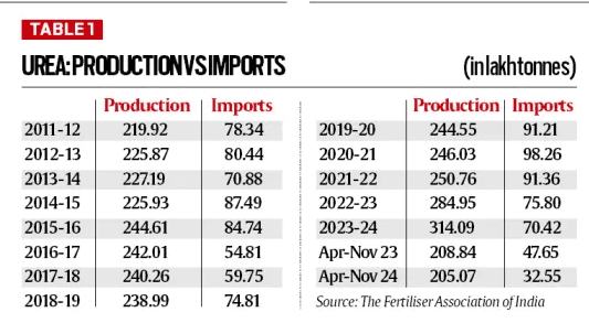
  • Import fall from 9.8 MT to 7 MT saves forex; still >₹70,000 cr subsidy.
  • Domestic cost > landed import due to LNG prices, but assured offtake via subsidy regime.
  • New eastern plants spur ancillary jobs, logistics and balanced regional industrialisation.

Environmental Impact

  • Energy-efficient 5 GCal/tonne units lower CO₂ emissions per tonne produced.
  • Controlled-release (neem, nano) products aim to cut soil nitrate leaching & water eutrophication.
  • Over-application persists; awareness campaigns crucial for sustainable nitrogen balance.

Key Data Points

FeatureData-Point
Installed capacity (2023-24)31.4 MT
Capacity in 2011-1222 MT
Import volume 2023-247 MT
Peak imports 2020-219.8 MT
Greenfield addition since 20197.55 MT
No. of new units (2019-23)6
Energy use – new plants≈5 GCal / tonne
Energy use – old plants5.5–6.5 GCal / tonne
Upcoming plantTalcher, Odisha
Key new operatorsHURL, Chambal, Matix

Related UPSC Prelims PYQs

CAPF_GAI, NDA_GAT 2022PYQ 1

Which one of the following statements about fertilizers is not correct?

CAPF_GAI, NDA_GAT 2025PYQ 2

Consider the following statements :

GS-1History

3.Lal Bahadur Shastri Death Anniversary (Freedom Movement Leader)

Indian Express
Illustration for Lal Bahadur Shastri Death Anniversary (Freedom Movement Leader)

What & Where

Lal Bahadur Shastri – 2nd Prime Minister of India (1964-66); born 2 Oct 1904, Mughalsarai (U.P.).

Tashkent Declaration – Indo-Pak peace accord signed Jan 1966 in Tashkent (then U.S.S.R.; now Uzbekistan).

59th death anniversary observed 11 Jan 2025; Shastri died in Tashkent hours after signing the accord.

Quick Facts for MCQs

Freedom Struggle

  • Gandhian-influenced; active Congress worker during civil disobedience era.
  • Reputation for humility, integrity, mass-contact skills.

Governance & Ethics

  • Accountability; resigned twice post-train accidents as Railways Minister.
  • Portfolios ranged Railways, Home, Commerce & Industry before premiership.
  • Slogan Jai Jawan Jai Kisan underscored soldier-farmer primacy in nation-building.

1965 War & Diplomacy

  • Leadership; directed armed forces during 1965 Indo-Pak conflict.
  • Tashkent Declaration sought status-quo ante & troop withdrawal after war.
  • Sudden Tashkent death still debated; mystery fuels inquiries and literature.

Key Data Points

FeatureData-Point
Birth date2 Oct 1904
BirthplaceMughalsarai, near Varanasi
Death11 Jan 1966, Tashkent
PM tenureJun 1964 – Jan 1966
Famous slogan“Jai Jawan Jai Kisan”
Key ministries heldRailways; Home; Commerce & Industry
Resignations as Railways MinTwice, after major train accidents
1965 War roleAuthorised military action to defend Kashmir
Peace pact signedTashkent Declaration, Jan 1966
2025 marker59th death anniversary
GS-1History

4.World Hindi Day 2025 Celebration (Hindi Language Promotion)

Indian Express

What & Where

Observance: World Hindi Day celebrated every 10 January worldwide to promote Hindi internationally

Commemoration: Recalls 1949 first Hindi speech at UNGA and 1975 inaugural World Hindi Conference

Distinction: Separate from Hindi Diwas on 14 September marking Hindi’s adoption as an official Indian language

Quick Facts for MCQs

Historical Milestones

  • Year 1949: Hindi debuted at UNGA, initiating global visibility
  • Event 1975: Nagpur first World Hindi Conference launched international forum
  • Resolution 2006: MEA fixed 10 Jan as World Hindi Day for diaspora outreach

Legal & Policy

  • Article 343: Hindi official language with English for Union functions
  • Schedule VIII: Hindi one of 22 constitutionally recognised languages
  • Celebration Hindi Diwas: 14 Sep observes 1949 constitutional adoption, separate from World Hindi Day

Demographic Significance

  • Speakers Count: ~600 million native+L2 users worldwide
  • Global Rank: 3rd most spoken after Mandarin, English
  • Domestic Status: Largest linguistic group within India, vital for outreach

Key Data Points

FeatureData-Point
Annual date10 January
First Hindi at UNGA1949
First World Hindi Conference1975, Nagpur
Designated as World Hindi Day2006 by MEA
2025 Theme“A Global Voice of Unity and Cultural Pride”
Global speaker rank3rd most spoken
Approximate speakers~600 million
Constitutional articleArticle 343
Schedule listing8th Schedule language
GS-1Environment

5.Wayanad 2024 Landslide Study Findings (Landslide Modelling)

The Hindu
Illustration for Wayanad 2024 Landslide Study Findings (Landslide Modelling)

What & Where

Landslide = downslope movement of rock/soil; rapid variant termed debris flow.

July 2024 event in Wayanad (Western Ghats, Kerala) triggered by extreme convectional rainfall on soil-over-rock slopes.

Study in Nature Natural Hazards used RAMMS run-out modelling to map paths, speed, pressure, deposition.

Quick Facts for MCQs

Tech & Schemes

  • RAMMS provides run-out path, velocity, pressure, deposition maps for mitigation design.
  • LRMS + National Landslide Risk Management Strategy fund slope stabilisation, monitoring, early warning.
  • Landslide Atlas of India (NRSC-ISRO) logs events for vulnerability assessment.

Environmental Impact

  • Debris build-up downstream elevates future flood and slide risk.
  • Landslides strip vegetation, amplify erosion, destabilise adjacent slopes.
  • Blocked streams may form temporary dams, causing secondary floods on breach.

Legal & Policy

  • NDMA guidelines mandate hazard zoning, structural & non-structural measures.
  • Gadgil panel sought whole Western Ghats ESA; Kasturirangan limited ESA to 37 %, banned mining there.
  • WGEA proposal under Environment (P) Act for statutory oversight (not yet operational).

Regional Contrast

  • Himalayas: tectonic quakes + snowmelt augment slides; Western Ghats: mainly monsoon rainfall, lower seismicity.
  • Himalayan slopes steeper, unconsolidated moraines; Ghats comparatively gradual, dual-layered soil-rock profile.
  • Deforestation rates higher in Himalayas, yet both regions see vegetation loss as key anthropogenic trigger.

Key Data Points

FeatureData-Point
Disaster dateJuly 2024
District & StateWayanad, Kerala
Earlier slides on same path1984 fatal, 2019 minor
Landslide-prone India0.42 mn km² (12.6 % land)
Share in Western Ghats & Konkan0.09 mn km²
Modelling toolRAMMS (Rapid Mass Movement Simulation)
Key hazard notedDebris accumulation at lower slopes
Needed sensorsRainfall & soil-moisture gauges
Arabian Sea trendWarming → deep cloud systems
Nature of rainfallLocalised convective bursts

Related UPSC Prelims PYQs

NDA_GAT 2022PYQ 1

Consider the following features about a geographical phenomenon:

GS-1MappingQuick Bite

6.Cyclone Dikeledi Strikes Mayotte (Indian Ocean Cyclone)

Down to Earth
Illustration for Cyclone Dikeledi Strikes Mayotte (Indian Ocean Cyclone)

What & Where

Cyclone Dikeledi: tropical storm that struck Mayotte, French Indian Ocean territory, January 2025.

Mayotte: two-island French overseas department (Grande Terre & Pamandzi) in Comoros archipelago.

Location: northern Mozambique Channel between Madagascar and mainland Africa, south-west Indian Ocean.

Quick Facts for MCQs

Historical Timeline

  • Colonisation: France seized Mayotte 1843; annexed entire Comoros archipelago 1904.
  • Referendum: 1974—95 % backed separation overall, yet 63 % of Mayotte opted to remain French.
  • Independence: Grande Comore, Anjouan, Moheli left French rule 1975; Mayotte retained Paris governance.

Disaster Management Angle

  • Frequency: Dikeledi followed Cyclone Chido within a month, highlighting rising storm activity.
  • Severity: Chido marked worst storm in 90 years for archipelago, stressing infrastructure limits.
  • Need: Recurrent cyclones demand stronger early-warning and coastal resilience in Mozambique Channel.

Socio-Economic Snapshot

  • Poverty: Mayotte stands as the EU’s poorest territory despite French administrative status.
  • Infrastructure: Insular isolation and limited resources hamper rapid disaster recovery.
  • Dependency: Core services, funds, and relief operations remain financed by mainland France.

Key Data Points

FeatureData-Point
Cyclone nameDikeledi
Hit territoryMayotte (France)
Oceanic zoneMozambique Channel
Component islandsGrande Terre & Pamandzi
French colonisation1843
Archipelago annexed1904
1974 Mayotte vote63 % stay French
Other Comoros independence1975
Poverty rankPoorest in France & EU
Previous worst stormCyclone Chido, Dec 2024, worst in 90 yrs
GS-1Mapping

7.Diego Garcia Atoll Dispute (Indian Ocean Island)

The Hindu
Illustration for Diego Garcia Atoll Dispute (Indian Ocean Island)

What & Where

Diego Garcia: coral atoll in central Indian Ocean, south of equator, within Chagos Archipelago.

Administered as British Indian Ocean Territory; entire atoll leased to United States for military base.

Chagos Archipelago: 50 + islands whose sovereignty is contested between United Kingdom and Mauritius.

Quick Facts for MCQs

Legal & Policy

  • ICJ-2019 advisory opinion deemed UK’s BIOT administration inconsistent with decolonisation obligations.
  • Mauritius continues diplomatic push for sovereignty; UK maintains de facto control.
  • Jurisdictional ambiguity complicates regional fishing rights and law-enforcement actions.

Security Dimension

  • Atoll leased to US since late-1960s, hosting strategic air-naval logistics hub.
  • Base enables sustained surveillance and force projection across Indian Ocean littorals.
  • No permanent civilians; strict exclusion zone enforced by UK/US patrols.

Fishermen Issue

  • Fifteen Tamil Nadu fishermen recently detained near Diego Garcia for alleged BIOT waters intrusion.
  • Indian External Affairs coordinating with UK to secure release and clarifications.
  • Case spotlights EEZ awareness gaps among deep-sea fishing communities.

Key Data Points

FeatureData-Point
Location zoneSouth of Equator, central Indian Ocean
ArchipelagoChagos
Atoll shapeV-shaped cay, open northern lagoon
Admin controlBritish Indian Ocean Territory (UK)
Lease holderUnited States military
DiscoveryPortuguese explorers, 16th century
ICJ 2019 advisoryFavoured Mauritius’ decolonisation claim
No. of Chagos islandsMore than 50

Related UPSC Prelims PYQs

GS1 2002PYQ 1

In the map given below, four islands of Indian Ocean region, i.e. A) Seychelles, B) Chagos, C) Mauritius and D) Socatra are marked as 1, 2, 3 and 4. Match them and select the correct answer from the codes given below.

GS1 2022PYQ 2

Which one of the following statements best reflects the issue with Senkaku Islands, sometimes mentioned in the news?

GS-1Mapping

8.Konkan Sada Lateritic Plateaus (Lateritic Plateaus)

The Hindu

What & Where

Sada = flat-top lateritic plateaus carved by prolonged erosion/weathering.

Stretch across Konkan coast, esp. Ratnagiri district, sandwiched between Arabian Sea & Western Ghats.

Monsoon turns rocky expanses into biodiverse, freshwater-harbouring mini-ecosystems; akin to Kaas Plateau (Satara).

Quick Facts for MCQs

Geology

  • Lateritic crust resists erosion, leaving elevated flats while softer materials wash away.
  • Plateau edges often display step-like scarps evidencing episodic weathering.
  • Location between coast & Ghats influences rapid drainage and soil stripping.

Biodiversity

  • Monsoon carpets sada with ephemeral herbs, tubers and endemic wildflowers.
  • Invertebrates, amphibians exploit temporary pools; several species Konkan-endemic.
  • Thin nutrient-poor soil limits woody vegetation, fostering specialised flora assemblages.

Hydrology & Ecosystem Services

  • Impermeable laterite stores rain, releasing slowly into surrounding valleys.
  • Act as seasonal grazing grounds and community water sources.
  • Absorb runoff, mitigating flash floods in lower coastal settlements.

Cultural Aspect

  • Local communities revere seasonal blooms; organise monsoon treks & fairs.
  • Traditional grazing patterns timed with post-monsoon grass flush.
  • Increasing ecotourism prompts calls for regulated access to prevent trampling.

Key Data Points

FeatureData-Point
Local name meaningSada = large flat area
Parent rock/soilLaterite
Core locationKonkan, Maharashtra
District hotspotRatnagiri
Comparable plateauKaas (Satara)
Key formation driverCenturies-long erosion & weathering
Peak ecological activitySouthwest monsoon months
Hydrological roleNatural freshwater catchments
GS-3Environment

9.Rat-Hole Coal Mining in India (Illegal Coal Mining)

The Hindu
Illustration for Rat-Hole Coal Mining in India (Illegal Coal Mining)

What & Where

Rat-hole mining: manual extraction of coal through crawable tunnels dug into thin seams

Two variants: Side-cutting along hill faces; Box-cutting vertical pit with horizontal drives

Dominant in Northeast hills—Meghalaya, Assam (Dima Hasao), Tripura—within Sixth Schedule tribal lands

Quick Facts for MCQs

Economic Angle

  • Wage premium; miners earn higher than farm or construction work
  • Quick returns; low capital outlay suits small landholders
  • Local demand; cement & thermal power plants sustain continuous offtake

Legal & Policy

  • NGT imposed nationwide ban on rat-hole mining May 2014
  • Sixth Schedule; landowners hold surface plus mineral rights limiting state control
  • Enforcement gaps; alleged official complicity enables clandestine operations

Geology & Terrain

  • Coal seams in NE thin & shallow, uneconomic for large mechanised mines
  • Rugged, forested slopes restrict heavy machinery deployment
  • High rainfall; pits prone to flooding, amplifying accident risk

Key Data Points

FeatureData-Point
DefinitionNarrow tunnel coal extraction
Key typesSide-cutting; Box-cutting
Core regionMeghalaya & adjacent NE states
Ownership regimeSixth Schedule tribal land & mineral rights
Regulator actionNGT blanket ban since 2014
Coal natureThin, shallow seams
TerrainHilly, high rainfall, forested
Main buyersCement & thermal power plants
Worker earningsHigher than farm/construction wages
Recent mishapFlood deaths in Dima Hasao mine
GS-3S&T

10.Purulia Astronomical Observatory (Astronomy Infrastructure)

The Hindu
Illustration for Purulia Astronomical Observatory (Astronomy Infrastructure)

What & Where

Advanced astronomical observatory housing a 14-inch optical telescope for research and training.

Set up by S N Bose Centre for Basic Sciences, autonomous under Department of Science & Technology.

Located on Panchet Hill (600 m), Garpanchakot, Purulia district, West Bengal; plugs 86° E longitudinal gap.

Quick Facts for MCQs

Tech & Schemes

  • Telescope: 14-inch Cassegrain class; enables photometry, spectroscopy, transient-event follow-ups
  • Observatory complements MACE gamma-ray project; strengthens multi-wavelength coordination
  • Funded by DST under national basic sciences promotion

Research Significance

  • Longitude 86° E offers night coverage between Europe and East Asia
  • Accelerates alerts for supernovae, GRBs, gravitational-wave optical counterparts
  • Data integrated into global time-domain astronomy networks

Regional Impact

  • Facility boosts local employment, science tourism, outreach in Purulia
  • Provides training for college students, PhD scholars, school groups
  • Potential nucleus for future astrophysics cluster in eastern India

Key Data Points

FeatureData-Point
Establishing bodyS N Bose Centre for Basic Sciences (DST)
Instrument size14-inch telescope
Site coordinatesPanchet Hill, Purulia, West Bengal
Altitude~600 m AMSL
Longitude served~86° E
Key purposeTime-domain observation of transient events
Indian peer observatoriesARIES–Nainital; Vainu Bappu–Tamil Nadu; IUCAA–Pune
Strategic valueBridges global longitudinal observation gap
Regional benefitSpurs STEM ecosystem in backward district
GS-3S&T

11.Nag Mk-2 Anti-Tank Guided Missile (Anti-Tank Missile)

Hindustan Times
Illustration for Nag Mk-2 Anti-Tank Guided Missile (Anti-Tank Missile)

What & Where

Nag Mk-2: third-generation, indigenously developed, fire-and-forget anti-tank guided missile (ATGM) by DRDO.

Designed for Indian Army armoured engagements; mounts chiefly on Nag Missile Carrier (NAMICA) or similar platforms.

Operates across validated minimum–maximum ranges, day/night, to neutralise tanks with Explosive Reactive Armour.

Quick Facts for MCQs

Tech & Schemes

  • Imaging-IR seeker enables autonomous homing in day, night, smoke.
  • IGMDP umbrella accelerated Nag family design, testing, production.
  • Modular design eases integration on ground or airborne launchers.

Security Dimension

  • Indigenous ATGM cuts import reliance, aligning with Atmanirbhar Bharat defence push.
  • Demonstrated capability bolsters deterrence against armoured incursions on western & northern fronts.
  • Technology showcase strengthens India’s profile among missile-exporting nations.

Operational Advantages

  • Fire-and-forget mode frees crew post-launch, raising survivability.
  • High hit probability minimises collateral damage in built-up battlefields.
  • Capability against ERA-equipped tanks future-proofs infantry anti-armour tactics.

Key Data Points

FeatureData-Point
GenerationThird
Guidance typeFire-and-forget
SeekerImaging Infra-Red (IIR)
DeveloperDRDO
Parent programmeIntegrated Guided Missile Development Programme (IGMDP)
Primary platformNAMICA tracked carrier
Armour penetrationDefeats Explosive Reactive Armour
Operational envelopeBoth minimum & maximum ranges validated
Launch versatilityLock-on-before-launch
Origin100 % indigenous

Related UPSC Prelims PYQs

CDS_GK 2021PYQ 1

भारत द्वारा विकसित ‘पिनाका’ क्या है?

GS-3S&T

12.Bacterial Esterase Degrades DEHP Plasticiser (Bioremediation)

The Hindu
Illustration for Bacterial Esterase Degrades DEHP Plasticiser (Bioremediation)

What & Where

Innovation: IIT Roorkee, India used esterase from soil bacterium Sulfobacillus acidophilus to biodegrade plasticiser DEHP.

Pollutant: Di-ethyl Hexyl Phthalate (DEHP) ― common PVC additive in toys, food containers; persistent, carcinogenic.

Process: Enzyme cleaves DEHP into phthalate + alcohol, then further enzymes yield water + CO₂.

Quick Facts for MCQs

Tech & Schemes

  • Integration: Gene-encoded esterase inside bacterial cells enables long-term, self-regenerating degradation.
  • Efficiency: Demonstrated rapid breakdown of high-molecular-weight plasticisers, outperforming earlier lab methods.
  • Structural-biology: Crystal data pinpoint catalytic residues guiding future enzyme engineering.

Environmental Impact

  • Detoxification: Converts persistent organic pollutant DEHP into benign molecules, curbing soil & aquatic toxicity.
  • Waste-management: Provides bio-remediation option alongside bans and mechanical recycling.
  • Ecosystem benefit: Lowers microplastic precursor load, aiding biodiversity protection.

Health Concerns

  • Exposure: DEHP absorbed via skin or food contact; infants at higher risk from toys.
  • Risks: Classified carcinogen; linked to endocrine disruption and developmental issues.
  • Urgency: Enzymatic removal complements regulatory limits on phthalate content.

Key Data Points

FeatureData-Point
Enzyme typeEsterase
Source organismSulfobacillus acidophilus
Host instituteIIT Roorkee
Target chemicalDiethyl Hexyl Phthalate (DEHP)
Technique usedX-ray crystallography for active-site mapping
End productsWater, Carbon Dioxide
Global plastic output 2023413.8 million metric tonnes
India’s plastic waste10.2 million tonnes / year
GS-2Misc

13.Gaza Israel-Hamas Truce Deal (Israel-Hamas Ceasefire)

Times of India

What & Where

Gaza Truce Deal: proposed cease-fire pact between Israel & Hamas, negotiated in Doha under Qatari mediation

Key processes: phased cessation of hostilities, hostage–prisoner exchanges, follow-up talks for durable peace

Geography: applies to Gaza Strip; negotiation hub Doha; stakeholders span Middle East & U.S.

Quick Facts for MCQs

Humanitarian Impact

  • Casualties: conflict caused 46,000+ Palestinian deaths, heavy civilian proportion
  • Pause: truce targets immediate aid corridors, medical evacuations, utility repairs
  • Hostages: framework envisions staged release of Israeli captives, Palestinian detainees

Political Implications

  • Israel: ceasefire may alter Netanyahu coalition arithmetic, rising domestic pressure
  • Region: reduced Gaza fighting expected to calm Lebanon border and Red Sea flashpoints
  • US: diplomatic win could boost Biden legacy before handover to Trump

Mediation & Diplomacy

  • Qatar: principal mediator, hosted secret and open rounds in Doha
  • Triad: U.S.–Egypt–Qatar operated joint shuttle diplomacy channel
  • Framework: phased truce segueing into broad political track toward two-state dialogue

Key Data Points

FeatureData-Point
Nature of pactCeasefire + hostage release
Primary belligerentsIsrael, Hamas
Mediator nationQatar
Supporting facilitatorsU.S., Egypt, Qatar
Negotiation venueDoha, Qatar
Reported Palestinian casualties>46,000
Timeline relevanceLate Biden administration
GS-2Misc

14.India Humanitarian Aid to Cuba (Disaster Relief)

All India Radio
Illustration for India Humanitarian Aid to Cuba (Disaster Relief)

What & Where

Cuba – island nation in Northern Caribbean Sea, between Gulf of Mexico & Atlantic Ocean.

Capital Havana – largest city; economic, commercial, industrial hub.

India rushed humanitarian aid post-Hurricane Rafael, reflecting Vasudhaiva Kutumbakam ethos.

Quick Facts for MCQs

Historical Ties

  • Recognition 1959; diplomatic warmth persisted through Cold War divergences.
  • Cuba supported India during 1962 Sino-India war diplomatically.

Economic Angle

  • Trade modest; India enjoys surplus driven by pharma and chemicals.
  • Nickel potential for future strategic mineral collaboration.

Development Assistance

  • Disaster Relief; aid after 2008, 2016, 2017 hurricanes and COVID-19 medicines.
  • IT Centre 2010; 1,900+ Cuban professionals trained.

Cultural Links

  • Gandhi, Nehru, Tagore commemorated; Tagore bust unveiled Old Havana 2007.
  • Yoga & Ayurveda events popular; International Day of Yoga observed annually.

Multilateral Support

  • Cuba backs India’s UNSC permanent seat demand.
  • Both coordinate in UN, NAM, WTO on South-South issues.

Key Data Points

FeatureData-Point
India recognised revolutionary CubaJanuary 1959
Cuba’s nickel production rank9th globally
India’s FY 22-23 exports to CubaUSD 79.04 million
India’s FY 22-23 imports from CubaUSD 4.87 million
Indian Lines of Credit to Cuba5 LoCs worth USD 243 million
Key Indian export itemsPharmaceuticals, chemicals, medical equipment, textiles
Key Cuban exports to IndiaTobacco, pharmaceutical products
Cuba in International Solar AllianceMember since 2015 launch
GS-2Misc

15.Iran Plans Capital Relocation to Makran (Capital Relocation)

Down to Earth
Illustration for Iran Plans Capital Relocation to Makran (Capital Relocation)

What & Where

Makran – semi-desert coastal plateau along Arabian Sea & Gulf of Oman, spanning Iran-Pakistan

Iran plans shifting capital from congested Tehran to Makran, Sistan-Baluchestan Province

Gedrosian Desert within Makran cost Alexander one-third of his army in 325 BCE

Quick Facts for MCQs

Strategic Geography

  • Location near Gulf of Oman grants direct Indian Ocean access
  • Corridor vision linking Central Asia trade through Chabahar & highways
  • Coast houses sizeable Iranian petroleum reserves

Ancient Military Campaign

  • Entry via Khyber Pass after Kabul conquest
  • Victory over Porus at Hydaspes, kingdom restored as ally
  • Troops mutinied at Beas, fearing Nanda strength, compelled retreat

Cultural Outcomes

  • Greek colonies founded: Alexandria-of-Arachosia, Boukephala
  • Interaction birthed Gandhara art blending Hellenic and Buddhist styles
  • Mauryan rise: Chandragupta exploited power vacuum post-Alexander

Environmental & Urban Issues

  • Tehran plagued by pollution, water scarcity, seismic vulnerability
  • Capital move aims population redistribution from 15 million megacity
  • Makran offers lower altitude heat, ample wind-solar potential

Key Data Points

FeatureData-Point
Tehran capital sincec. 1796 under Qajar Agha Mohammad Khan
First shift proposalMahmoud Ahmadinejad era, early 2000s
Makran coastline length~1,000 km
Iranian port on coastChabahar
Pakistani port on coastGwadar
Chabahar FTZ start2003
Nearby chokepointStrait of Hormuz, major oil route
Alexander’s India campaign327 – 325 BCE
Hydaspes battle riverJhelum
Army halted atHyphasis / Beas River
Infantry taken to India~1,20,000
Return survival rate≈25 %
Main Greek sourceArrian’s Anabasis of Alexander
GS-2Scheme

17.Mission Mausam Weather Modernisation (Weather Forecasting)

DD News

What & Where

Mission Mausam = national modernisation drive for weather-and-climate observation, forecasting and air-quality monitoring.

Launched by Prime Minister on IMD’s 150th Foundation Day; executed by IMD under Ministry of Earth Sciences.

Pan-India rollout of radars, satellites and HPC centres to create a “weather-ready, climate-smart” nation.

Quick Facts for MCQs

Tech & Schemes

  • Next-gen radars; dual-polar, longer-range network for real-time mesoscale tracking.
  • HPC upgrades; enables sub-kilometre numerical weather prediction models.
  • Satellite additions; continuous cloud-land-ocean scans improve nowcasting.

Sectoral Impact

  • Agriculture; precise rainfall/temp guidance for sowing, irrigation, pest alerts.
  • Disaster management; earlier cyclone, flood, heatwave warnings reduce loss.
  • Aviation & defence; enhanced wind, turbulence, visibility data raises mission safety.

Climate & Air Quality

  • High-resolution reanalysis datasets feed climate risk assessments & adaptation plans.
  • Integrated sensors deliver city-level AQI forecasts supporting NCAP interventions.
  • Data backbone aids energy, health sectors in pollution-related decision-making.

Policy Alignment

  • Complements IMD Vision-2047 goal of climate-resilient infrastructure.
  • Supports National Framework for Climate Services by widening sectoral outreach.
  • Reinforces India’s climate-mitigation commitments via improved evidence base.

Key Data Points

FeatureData-Point
Nodal ministryMinistry of Earth Sciences
Implementing agencyIndia Meteorological Department
Launch occasion150th Foundation Day of IMD
Aim statementMake India weather-ready & climate-smart
Core hardwareNext-gen radars, satellites, HPC systems
Extra moduleIntegrated air-quality monitoring
Sectoral beneficiariesAgriculture, disaster mgmt, aviation, defence, energy, health
Long-term linkageIMD Vision-2047 roadmap
GS-2Scheme

18.Odisha Adoption of Ayushman Bharat-PMJAY (Health Insurance)

PIB

What & Where

Ayushman Bharat–Pradhan Mantri Jan Arogya Yojana: national health-insurance for secondary & tertiary care.

Odisha joins as 27th state; Delhi & West Bengal still out.

Runs parallel to state-led Gopabandhu Jan Arogya Yojana within Odisha.

Quick Facts for MCQs

Funding Pattern

  • Ratio — 60:40 general; 90:10 NE, Himalayan states, UTs
  • Category — Centrally Sponsored, states retain opt-out choice
  • Convergence — Odisha finances AB PM-JAY alongside GJAY

Coverage & Beneficiaries

  • Limit — ₹5 lakh per family + ₹5 lakh women top-up
  • Reach — 1.03 crore Odisha families expected to benefit
  • Nationwide — 55 crore persons, 12.3 crore families, 45 % population

Healthcare Network

  • Empanelment — 30,985 hospitals; 41 % private participation
  • Procedures — 2,000 + secondary/tertiary packages across 27 specialties
  • Senior focus — all citizens aged 70 + receive free treatment

Key Data Points

FeatureData-Point
Scheme typeCentrally Sponsored
Cost share (general)Centre 60 : State 40
Cost share (NE/Himalayan/UTs)Centre 90 : State 10
Adopting state no.27 – Odisha
Non-adoptersDelhi, West Bengal
Annual cover per family₹5 lakh
Extra cover for womenAdditional ₹5 lakh
Odisha beneficiary families1.03 crore
National individuals covered55 crore (≈45 % population)
National families covered12.3 crore
Senior citizen perkFree care for 70 +
Empanelled hospitals30,985 (12,881 private)
Procedures offered2,000 + across 27 specialties

Related UPSC Prelims PYQs

CDS_GK, GEO_GS 2020PYQ 1

Which one of the following is not a feature of the Ayushman Bharat Scheme?

CDS_GK, GEO_GS 2020PYQ 2

Centrally sponsored scheme Ayushman Bharat is a national health insurance system for:

GS-1Misc

19.Hysterectomy Prevalence Patterns in India (Women's Health)

The Hindu
Illustration for Hysterectomy Prevalence Patterns in India (Women's Health)

What & Where

Hysterectomy = surgical removal of uterus; permanently stops menstruation & pregnancy

Done for fibroids, endometriosis, abnormal bleeding, pelvic inflammatory disease, cancer, severe pelvic pain after failed therapies

NFHS-5: highest prevalence Andhra Pradesh 9 %, Telangana 8 %; lowest Sikkim 0.8 %, Meghalaya 0.7 %

Quick Facts for MCQs

Social Concerns

  • Agricultural women: poor hygiene, menstrual taboos, delayed gynaec care, heavy labour drive early surgery
  • Affluent women: better affordability & access spur elective procedures
  • Migration case: Beed sugarcane cutters report unusual surgery clusters

Medical Indications

  • Standard triggers: fibroids, endometriosis, abnormal uterine bleeding, PID, malignancy, unresponsive pelvic pain
  • Performed only after non-surgical measures fail; irreversible loss of fertility

Policy & Schemes

  • RSBY reimbursement can unintentionally incentivise unnecessary hysterectomies
  • NFHS-4 highlighted socio-economic skew; spurred calls for stricter procedure audits

Key Data Points

FeatureData-Point
NFHS-5 national prevalence (15-49 yrs)3 % women undergone hysterectomy
Highest stateAndhra Pradesh 9 %
Second-highest stateTelangana 8 %
Lowest statesSikkim 0.8 %; Meghalaya 0.7 %
Region with max casesSouth India 4.2 %
Region with min casesNortheast 1.2 %
NFHS-4 key findingHigh rates in low-income farm workers & affluent women
Illustrative hotspotBeed district, Maharashtra (female sugarcane workers)
Incentive-linked schemeRashtriya Swasthya Bima Yojana (RSBY)

Ready to practice?

Test your knowledge with our UPSC test series.

Start Free Trial