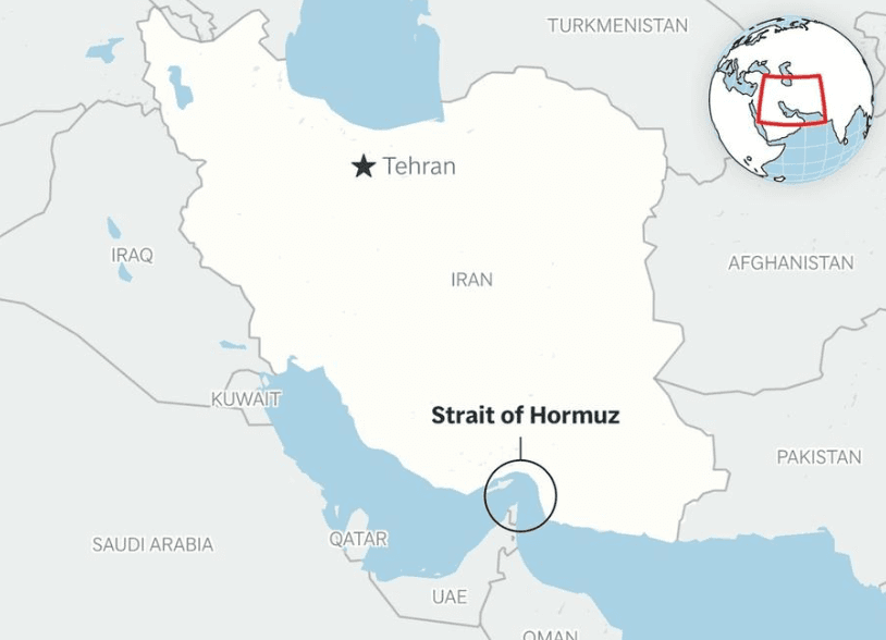
What & Where
Chokepoint: world-vital maritime passage connecting Persian Gulf to Gulf of Oman and Indian Ocean
Location: separates Iran’s southern coast from Oman’s Musandam Peninsula, flanked westward by UAE
Exit-route: only seaway for Persian Gulf hydrocarbons toward global markets
Quick Facts for MCQs
Security Dimension
- Drill: Iran’s “Smart Control of the Strait of Hormuz” briefly closed sections for live-fire exercises
- Presence: Iranian forces stationed on strategic islands enabling de facto control of shipping lanes
- Signal: Exercise coincided with Geneva nuclear talks, messaging U.S. amid heightened regional tensions
Economic Angle
- Price-shock: Any slowdown instantly elevates global crude prices and maritime insurance premiums
- Volume: Route handles ~20 % world petroleum, making alternatives economically unviable
- Carrier-fit: Depth accommodates VLCCs, essential for bulk crude economics
Physical Geography
- Depth: 60–100 m central channel contrasted by hazardous shallow coastal shelves
- Funnel: Musandam Peninsula creates narrow throat forcing dual 3-km lanes with 2-km buffer
- Climate: Hot, clear conditions aid navigation but strong currents near island clusters pose risk
Key Data Points
| Feature | Data-Point |
|---|---|
| Total length | ~167 km |
| Narrowest width | ~33 km |
| Inbound lane width | 3 km |
| Outbound lane width | 3 km |
| Buffer zone | 2 km |
| Average depth | 60–100 m |
| World petroleum share | ≈20 % daily |
| World LNG share | ≈20 % daily |
| Daily oil volume | ~20 million barrels |
| Bordering nations | Iran, Oman, UAE |
| Key Iranian islands | Abu Musa; Greater & Lesser Tunbs; Qeshm; Hormuz; Larak |